
-
 26249 Hits
-
 84.27% Score
-
 18 Votes
|
|
Area/Range |
|---|---|
|
|
37.94745°N / 107.39685°W |
|
|
Hiking, Mountaineering, Scrambling, Skiing |
|
|
Spring, Summer, Fall, Winter |
|
|
14019 ft / 4273 m |
|
|
Overview
The La Garita Mountains are a sub-range of the San Juans in southwest Colorado and comprising parts of the Rio Grande and the Gunnison National Forests. This lesser known wilderness area in COlorado is actually one Colorado's original five wilderness designations. La Garita means "the lookout" in spanish and this name is reflecting of the only fourteener in the area. This one is San Luis Peak and is often regarded as one of the tougher ones to get to despite being very gentle and easy to climb.
These mountains serve as the primary source for the Rio Grande River which flows south and east through Colorado and into New Mexico and Texas before dumping into the Gulf of Mexico.
Very large amounts of elk and deer thrive in the forests in the La Garita mountains and this area is one of the richer places for hunting during the season. One of the best parts of the Colorado Trail pass through the heart of the La Garitas and mostly being above tree line allowing for one of the most scenic sections of the trail.
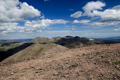
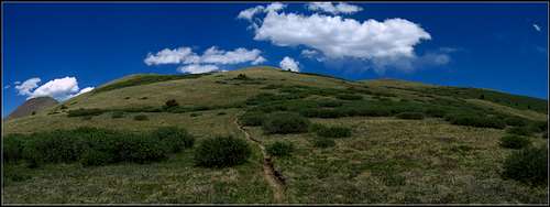
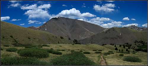 San Luis Peak from the Colorado Trail
Getting There
Nearby towns include Creede, Lake City, Saguache, Gunnison and South Fork. Most trailheads into the La Garitas are outside Creede and Gunnison. Principal trailheads that provide trail access into the area are Stewart Creek and West Willow Creek.
Stewart Creek TH - Gunnison
From Highway 50 near Gunnison head south for 20 miles on CO 114 and turn right onto the Old Agency Road (FS 3083). Follow Cochetopa Creek for 3.5 miles and turn right onto FS 3084 which will turn into FS 788. After 8.8 miles on this road bear left onto FS 790 and follow this for 10 more miles. Turn left onto FS 794.28 (also Perfecto Creek Road) and continue 4 miles crossing two creeks and then make a right on FS 794. Continue 4.5 miles to the trailhead where you will have just driven 30 miles on dirt roads! This trailhead is very inaccessible in the winter as are most of the peaks in the La Garita Wilderness.
West Willow Creek TH - Creede
This trailhead gives access to the Colorado Trail just southwest of San Luis Peak. At the south end of Creede on Colorado 149, there is a bridge crossing Willow Creek. From this bridge, go south on CO 149 only 0.3 miles where you will see three well groomed dirt roads heading west. Turn on the road furthest north and climb up the hill as it curves around Creede from above. You should pass the Creede cemetary after a half mile on the dirt road and after about 1.2 miles make a left at the T junction. Continue 5 more miles to Allens Crossing where the road crosses West Willow Creek. Shortly past this crossing turn left at the T junction. There were lots of heavy equipment parked here in summer 2011. Continue north on the still nice road to the Equity Mine which as of summer 2011 is back in operation. You will probably have to park a bit below the mine.
In late June 2011, workers began preparing the area for re-opening. By mid-July I believe the whole area was closed. Inquire before heading to this trailhead to see where you can park and whether you will be allowed to walk through the mine area to access the Colorado to the north. A 4WD road continues north from the Equity Mine and initially starts on the west side of the creek and crosses it twice before it ends at about 11,500 feet in elevation, only 400 feet above the mine. The Colorado Trail runs above treeline through the whole range passing over Spring Creek Pass in the west and traversing over three more unnamed passes before descending along Cochetopa Creek in the east.
The Equity Mine marks the trailhead for the West Willow Creek approach. There are many old mining ruins here and this spot is easily accessed with a passenger car. The other trailheads may be a little rougher and require high clearance vehicles. The best way to climb San Luis is to start from the Equity Mine (if still allowed) and hike the Colorado trail to the base of the long and gentle south ridge.
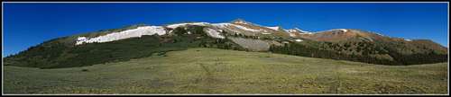
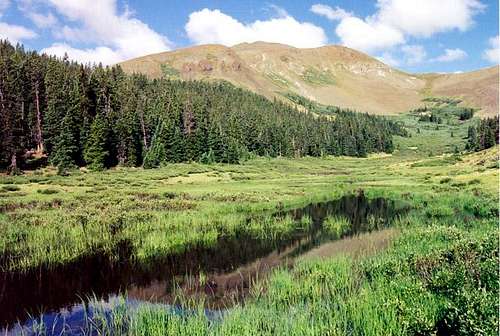
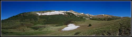 View above West Willow Creek near Spring Creek Pass
Geology
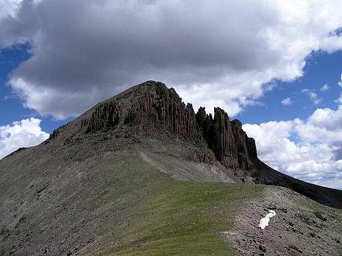
The rocks seen in the La Garita mountains are similar to the rocks seen throughout much of the San Juans which are distinctly different than the rest of Colorado. Most of Colorado's mountains are made up of Pre-Cambrian gneiss, schist and granite. However extensive Tertiary volcanics in southwestern Colorado driven by the Rio Grande Rift about 30 million years ago caused the deposition of volcanic deposits ranging from a few hundred to many thousands of feet thick. These volcanic tuff and lava flow deposits sit well above the Pre-Cambrian rocks like the ones seen in the Sawatch or Front Ranges. Unfortunately these rock types are terrible for climbing and large amounts of alteration and weathering have changed most of these rocks into a crumbly mess.
Basalt flows that cooled after an eruption form columnar basalt and these columns are seen all over the La Garitas. The largest volcano that existed during this time 30 million years ago was the La Garita caldera which is known to have erupted a few times with an intensity that was 10,000 times larger than the Mt. Saint Helens eruption in Washington state in 1980. The mountain that was associated with the La Garita caldera was at one point 20,000 feet above sea level. What remains today are the piles of volcanic rock that were deposited and later eroded into the current high points and valleys of the San Juans we see today.
Think about this though...ten thousand times larger then St. Helens. It's no wonder that the San Juans as a whole are so different. The whole area is covered in thousands of feet of volcanic debris that consolidated to form rock. Remnants of the La Garita caldera as well as others are seen in the area especially if one looks at aerial photos.
One of the most spectacular geologic areas in Colorado is the Wheeler Geologic Area. This area accessed using the East Bellows Trail and requires a good 4WD to get anywhere close to. The strange spires of colorful rock similar to what is seen in Utah at Bryce Canyon represent ash flow deposits that were deposited during the large volcanic eruptions 25-30 million years ago. When extensive falling ash came to the ground it mixed with areas of running water and mud and became an ash flow which deposited like a mud-flow in the topographic lows of the time.
After lithification and subsequent millions of years of weathering and leeching by water seepage, the tuff deposits turned to clay. Today all these deposits sit as bentonite clay like what is extensively seen in Utah. Be careful in this area when driving because an afternoon thunderstorm makes the area impossible to drive on and very hard to even walk on. Due to the alteration of all the volcanic rocks in the San Juan volcanic field there are many areas where great rock and mineral specimens can be found. If you are interested in a more extensive analysis of the geology of the area or other parts of Colorado send me a PM. I've been studying this and can tell you much more or answer any questions you may have about the geologic history.
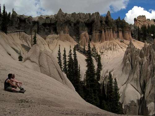 Wheeler Geologic Area spires
Hiking and Climbing
There are six major summits in the La Garita Mountains that are above 13,500 feet in elevation. Three of these peaks are centennials (one of the highest 100 in Colorado). San Luis Peak, the only 14er in the range, has many easy scenic hiking routes to its broad summit.
| Six Highest Peaks | ||||
| Rank | Peak Name | Feet | Meters | |
| 1. | San Luis Peak | 14,014 | 4271 | |
| 2. | Stewart Peak | 13,983 | 4262 | |
| 3. | Phoenix Peak | 13,895 | 4235 | |
| 4. | Organ Mountain | 13,801 | 4207 | |
| 5. | La Garita Peak | 13,710 | 4179 | |
| 6. | Baldy Alto | 13,698 | 4175 | |
These peaks are one of the major reasons people come to this area. They are all unique climbs and different from the rest of Colorado. There are also a number of unranked and unnamed 13ers nearby but these are the big ones. They offer a great climbing and hiking experience. Even though the area is very gentle there is one class 3 ridge traverse hidden in the middle of the wilderness between San Luis Peak and Organ Mountain. It's this route that people do when they are looking for both peaks in one day.
The Colorado Trail, or the "hiking freeway" as I like to call it passes right by San Luis Peak and starting from the Equity Mine one can hike 7 miles on this trail passing by Spring Creek Pass and climb San Luis on its south ridge. This route is the one I'd recommend over the Stewart Creek approach.
Use the Stewart Creek route if you wish to Climb Stewart or Organ Mountains.

All these summits have spectacular views and won't disappoint. People hiking the entire Colorado Trail often will climb San Luis as a side hike however simply staying on the trail through the wilderness is more than enough beauty for many people. Peak-baggers will want to climb to the summit of these mountains despite the views not being too much better than the ones on the surrounding Colorado Trail.
Camping
Camping can be found on most of the dirt and 4WD roads leading into the area. Great camping can be found at the Equity Mine although be prepared for overnight mining work here. Kept me awake a bit.
The gentle meadows throughout the La Garitas can make for a plethora of camping spots anywhere in the wilderness. If you camp along dirt roads be sure to leave enough room for others to pass.
More Photos
 San Luis Peak from the Colorado Trail San Luis Peak from the Colorado Trail |
 San Luis, Organ and Stewart from Phoenix Peak San Luis, Organ and Stewart from Phoenix Peak |
 View from Spring Creek Pass View from Spring Creek Pass |
 Spring Creek Pass Spring Creek Pass |
 San Luis Peak from Stewart San Luis Peak from Stewart |
 Phoenix Peak from La Garita Peak Phoenix Peak from La Garita Peak |
 View to the north from the summit of Phoenix Peak View to the north from the summit of Phoenix Peak |
 Hiking on the Colorado Trail just above Spring Creek Pass Hiking on the Colorado Trail just above Spring Creek Pass |
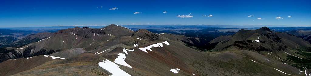
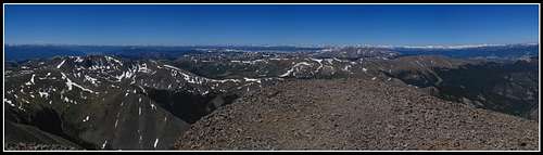 San Luis Peak summit panorama San Luis Peak summit panorama |
 Organ Mountain Organ Mountain |
 Stewart Peak reflection Stewart Peak reflection |
 Stewart Peak |
Red Tape
This is a wilderness area so no motorized vehicles are allowed within the wilderness but there is no cost to come here. As far as I know all the trailheads are free to park at. Respect the private property at Equity Mine and don't wander near the active mine workings.
External Links
 Stewart Peak
Weather Forecast
Avalanche Forecast
Stewart Creek Trailhead Current Conditions
Good Winter Trip Report
Gunnison National Forest
2250 Highway 50
Delta, Colorado 81416
(970) 874-6600