
|
|
Area/Range |
|---|---|
|
|
39.88000°N / 105.804°W |
|
|
Hiking, Trad Climbing, Bouldering, Mixed, Scrambling, Skiing |
|
|
Spring, Summer, Fall, Winter |
|
|
Overview
The James Peak Wilderness Area was designated in 2001, and comprises 14,000 acres. It is located on the east side of the Continental Divide, between Beuthold Pass to the south and Rollins Pass to the north. It is situated in Boulder, Gilpin and Clear Creek Counties of Colorado and is part of both the Roosevelt and Arapaho National Forests. It is separated from the Indian Peaks Wilderness Area by Rollins Pass.
The area's elevation ranges from 9,200 feet to 13,294 feet and includes upper montane, sub-alpine and alpine ecosystems. Numerous mountain lakes dot the landscape. Peaks can be summited via easy hikes, or more adventuresome 5+ climbs. During the winter many of the summits can be climbed and then ski or boarded down.
The James Peak Wilderness isn't nearly as big or as rugged as it's northern neighbor, Indian Peaks Wilderness, but it isn't as visited either, so if you are looking for solitude this is a good place to come even though it is only a short distance from Denver.
List of named peaks in James Peak Wilderness
Peak NameElevationQuadrangleLatitudeLongitude
| Parry Peak | 13,391' | Empire | 39.8380 | 105.7133 |
| James Peak | 13,294' | Empire | 39.8519 | 105.6901 |
| Mount Bancroft | 13,250' | Empire | 39.8376 | 105.7002 |
| Mount Flora | 13,132' | Empire | 39.8073 | 105.7355 |
| Mount Eva | 13,130' | Empire | 39.8276 | 105.7189 |
| Witter Peak | 12,884' | Empire | 39.8143 | 105.7162 |
| Colorado Mines Peak | 12,493' | Beuthoud Pass | 39.7949 | 105.7638 |
| Haystack Mountain | 11,780' | Empire | 39.8667 | 105.6924 |
| Nebraska Hill | 11,534' | East Portal | 39.8806 | 105.6510 |
List of unofficial named peaks
Peak NameElevationQuadrangleLatitudeLongitude
| Heartbeat Peak | 12,251' | East Portal | 39.8810 | 105.6984 |
| Sprint Peak | 12,110' | East Portal | 39.9040 | 105.6872 |
| Radiobeacon Mountain | 12,072' | East Portal | 39.9175 | 105.6823 |
Panorama, from Cone to James
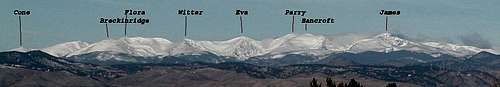 From north to south are Cone Mountain, Breckinridge Peak, Mt. Flora, Witter Peak, Mount Eva, Parry Peak, Mount Bancroft and James Peak covered in snow as seen from the Denver Tech Center
Trailhead Access
The James Peak Wilderness can be accessed by a number of trailheads. These trailheads are divided between east and west of the Divide.
East of the Continental Divide, from north to south:
East Portal/Moffat Tunnel
- Lower Mammoth Gulch
- Upper Mammoth Gulch
- St. Mary's Glacier
- Loch Lomond
- Fall River Road
- Fall River Reservoir
West of the Continental Divide, from south to north:
- Beuthold Pass
- Jim Creek
- Riflesight Notch/Rogers Pass
Camping and Lodging
Camping
Camping is allowed in the James Peak Wilderness, however there are no established campsites. There are no use and camping fees and permits are not required to use or camp within the James Peak Wilderness Area, however there are restrictions, which are detailed in the Red Tape section.
The U.S. Forest Service has two campgrounds along U.S. 40, north of Beuthold Pass. The first campground north of the Pass is Robbers Roost on the east side of the road. The next campground, Idlewild, is past the Winter Park ski area, it too is on the east side. Both of these campgrounds are small and along the Frasier River. Both of these campgrounds are basically open from Memorial Day to Labor Day.
Another Forest Service campground is located northwest out of Central City. Follow CC3 out of Central City, and then turn left onto CC2 and the Columbine campground is at the end of the road.
The last Forest Service campground in the area is the Pickle Gulch group campground which is off of CO 119 near Missouri Lakes. Turn northwest off of CO 119 at Missouri Lakes and the Pickle Gulch campground is less than a mile up the dirt road. This campground requires reservations.
In addition to the developed campgrounds, the Forest Service allows dispersed camping, however you need to make sure you follow the rules and regulations of the Forest Service for dispersed camping.
Lodging
There are numerous motels in Idaho Springs, Georgetown and in the Winter Park area and there might be one or two places to stay along U.S. 40 between I-70 and Beuthold Pass. I cannot attest to the quality of any of these motels since I haven't stayed at any of them. And if you would like to gamble your money away, Central City and Blackhawk have abundant casinos and lodging.
Red Tape
Being that is is a Wilderness Area, motorized equipment and mechanical equipment used for transportation are prohibited with the boundaries of the Wilderness Area. This includes motor vehicles, motorboats, bicycles, hang gliders, wagons and carts.
- Campfires are prohibited.
- Camping is permitted, however camping within 100 feet of lakes, streams and trails is prohibited.
- Pets are to be leashed and under physical control.
- Maximum group size is limited to 12 people or a combination of 12 people and pack animals.
- Grazing of pack animals is prohibited and only certain types of feeds are allowed.
- Hobbling, tethering or picketing of pack animals with 100 feet of streams, lakes or trails is prohibited.
- Leave no trace
External Links
If you have a desire to read the actual legislation that created the James Peak Wilderness click here