
|
|
Area/Range |
|---|---|
|
|
40.00888°N / 105.58971°W |
|
|
Hiking, Mountaineering, Trad Climbing, Ice Climbing, Skiing |
|
|
Spring, Summer, Fall, Winter |
|
|
Overview
The Indian Peaks Wilderness (IPW) was established by US Congress in 1978. With the addition of 3000 acres in 2002, IPW currently covers 76,711 acres. (source)
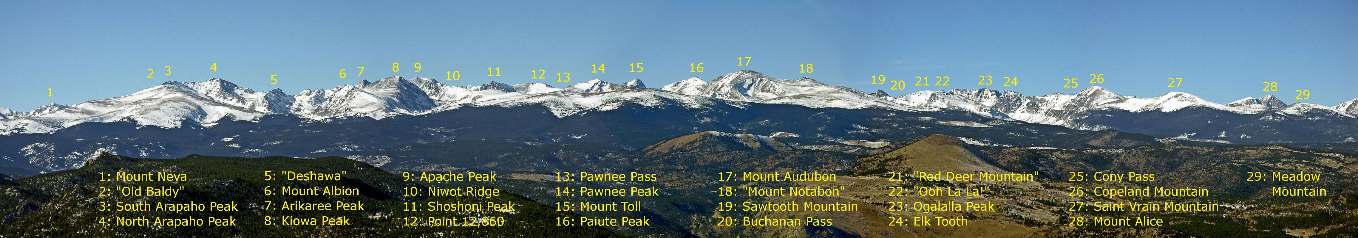
Located south of Rocky Mountain National Park, IPW includes the stretch of the Continental Divide that goes from Ogalalla Peak to Rollins Pass.
Within the boundary of the wilderness are seven peaks over 13,000 feet (eight if one counts Dicker's Peck, six if one omits South Arapaho Peak; neither meets the local criteria for a ranked summit, but South Arapaho is too conspicuous to be left out. A complete list of IPW summits has been compiled by noted guidebook author and IPW expert Gerry Roach.
  |
Geology
The Indian Peaks have a complex structure in which several types of rock coexist: Metamorphic rocks (including biotite gneiss and schist) formed over 1.7 billion years ago, as well as intrusive rocks like Silver Plume Granite from 1.4 billion years ago, and the much more recent Audubon-Albion stock. (Various rocks intruded during the Laramide orogeny; they are believed to be about 68 million year old.)
The glaciation in the Quaternary carved high cirques, U-shaped valleys, and numerous lakes, thus giving the Indian Peaks the appearance they still show today. Arapaho Glacier is the largest glacier in Colorado. Navajo and Isabelle glaciers are also true, albeit small, glaciers.
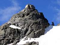
Selected Hikes and Climbs
This is a highly subjective and incomplete list. Feel free to suggest changes and additions.

Evening light on Lone Eagle

South to North Arapaho Traverse

Watanga Mountain

Mount Toll

Jasper Peak and Mount Neva
Navajo Peak
Day Hikes:
- Pawnee Peak via Pawnee Pass
- Mount Audubon from the Mitchell Lake Trailhead
- Lake Dorothy from Fourth of July Trailhead
- Buchanan Pass from Beaver Creek Trailhead
- Crater Lake from the Monarch Lake Trailhead
Scrambles:
- South and North Arapaho traverse
- Lone Eagle's Solo Flight
- Mount Neva's North Ridge
- Niwot Ridge
- Ogalalla Peak via Elk Tooth
- Mount Audubon's southeast ridge and Paiute Peak's east ridge
Snow Climbs:
- Skywalker Couloir on South Arapaho
- Apache Couloir
- Shoshoni Peak's Southwest Couloirs
- Superstar Couloir on James Peak
Rock climbs:
- Lone Eagle's North Face
- Devils Thumb
- Mount Toll's North Ridge
While there is abundance of snow climbs in the IPW (Jasper Peak, Mount Neva, the Arapahos, Navajo and Apache Peaks, Mount Audubon, and Ooh La La! all offer good choices), only a handful of rock routes are well known and even those are not so often repeated. This is due in part to long approaches, and in part to the relative scarcity of good rock. The best rock from a climber's standpoint is the Silver Plume Granite, which makes up Shoshoni Peak, the Chessmen on the ridge between Shoshoni and Apache, Lone Eagle, and its "parent peak" known as Iroquois.
It may be that the lure of nearby Rocky Mountain National Park has kept climbers away from the Indian Peaks. It may be that the climbers who frequent them are secretive. If you know something or have an interesting conjecture, please share it.
Access
The Indian Peak Wilderness is served by several trailheads that are conveniently divided according to the side of the Continental Divide on which they are located. East of the Divide, from north to south, we find:
- Mount Saint Vrain Trailhead
- Middle Saint Vrain Trailhead
- Beaver Creek Trailhead
- Mitchell Lake and Long Lake Trailhead, both in the vicinity of Brainard Lake
- Rainbow Lakes Trailhead
- Fourth of July Trailhead
- Hessie Trailhead
- Rollins Pass Trailhead
West of the Divide, again from north to south, we have:
- Roaring Fork Trailhead
- Monarch Lake Trailhead
- Meadow Creek Trailhead
- Devils Thumb Park Trailhead
- Rollins Pass Trailhead
Three major passes, Buchanan Pass, Pawnee Pass, and Arapaho Pass allow transit from one watershed to the other.
Access to the trailheads during the off-season depends on snow accumulation and on road closures. In particular, the Brainard Lake road is open from about mid June to mid October. The exact dates are set each year by the Forest Service depending on the conditions. For up-to-date information, call the Boulder Ranger District at (303)541-2500.
An important chunk of land immediately east of the Continental Divide is owned by the City of Boulder and permanently closed to the general public. The peaks affected, wholly or in part, by this restriction are Kiowa Peak, Arikaree Peak, Mount Albion, "Deshawa," Navajo Peak, "Old Baldy," and the Arapaho Peaks. It is not clear why Boulder and Barker Reservoirs are open to recreational use, but the summit of Arikaree Peak, for instance, is not.
Camping
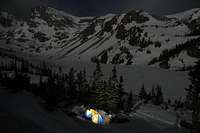
Camping near Lake Isabelle
The Indian Peaks Wilderness is divided, with regard to camping, into backcountry zones. The details of regulations (e.g., when a permit is required) depend on the zone; they can be found here. How to request permits is explained here.
Mountain Conditions
The Indian Peaks' contact information page lists useful addresses and phone numbers. A webcam on Niwot Ridge allows one to get an idea of the conditions in the Indian Peaks. Detailed forecasts are provided by NOAA. This link, for instance, gives point forecasts for North Arapaho Peak.
Afternoon thunderstorms are common in summer and pose a significant threat: Plan your trip so as to be below treeline in the afternoon. Never forget that the weather may change very rapidly in the high country. The temperature may drop by 50°F or more in a couple of hours. Those who have been caught out by such sudden changes without proper equipment and preparation have not always survived.
During the ski season, consult the Colorado Avalanche Information Center for snow conditions.