
|
|
Mountain/Rock |
|---|---|
|
|
35.96720°N / 79.44350°E |
|
|
Mountaineering |
|
|
20899 ft / 6370 m |
|
|
Overview
 Jiao seen from 5900m on Qierlizuoke Feng
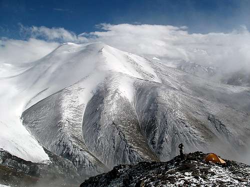
The most famous peak in the "Dahongliutan Range" is probably...none of them. The range has gotten very little attention even if it consists of high, beautiful and unclimbed peaks. Some are close to 7000m and still have untouched summits. Jiao Feng's closest neighbor is one of them, the massive Qierlizuoke Feng (QF) at 6802m which dominates the range together with an unnamed pyramid shaped giant. As far as I know there have only been two expeditions to the main range. One Japanese in 1996 and one American in 2004. The former climbed Khan Yailik (6744m) and the latter made four ascents further west.
Jiao Feng is a bulky peak just south of QF, connected with a sharp ridge which later become the long SE ridge of QF. There are many ways to climb Jiao Feng, but the most obvious is an approach on the NW side as all other sides involve getting over or around glaciers or very steep scrambling on scree slopes. A couloir to the NW offers very nice snow climbing, but unfortunately it was too prone to avalanche when we were there.
One of the main reasons I climbed the peak was to get views of QF. We had been up on the latter two days back, almost got avalanched a couple of times and now we wanted to make sure we made a good route choice on the next try. I consider I have been on many mountains and have had some great views in many places. Reaching the summit of Jiao Feng may beat them all. It was a perfectly clear and warm day. I was in cotton pants, a thermal underwear sweater and a windbreaker, on 6400m! All around us were the snow capped peaks of the Kunlun and in the distance the Chinese Karakoram.
 Avalanches on surrounding peaks
The name.
We baptized it to Jiao Feng as we couldn't find any info about the peak anywhere. If I, or anyone else, find the correct name, I'll change it at once. Jiao means Horn and we found it a suitable name as there are some pointed horn-like highpoints on the summit ridge. Feng simply means peak in Chinese.
Getting There
 The walk in valley
Jiao Feng is located a long way into the wilderness of China
From Xinjiang - Kashi/Kashgar
Kashgar is an oasis town on the brink of The Taklamakan Desert. It has always been a transport hub and it's the last place where you can find flights and railway transport to.
From here there are basically two alternatives:
1. With a group in a rented (it comes with a driver in China, as foreigners aren't allowed to drive on their own) vehicle, usually a Landcruiser. Travel agents in Kashgar can arrange travel permits, a vehicle, a guide and everything else you may want or need.
2. Using local transport or hitching.
Take a bus to Yecheng/Kargalik. It's about 4 hours on good road and the cost is about $5-6.
Get a local bus to the little junction settlement of Aba. About 10-15min/$0.6-0.8
The bus station for transport towards Jiao Feng is located about 1km from the turnoff from the main road, on the left hand side of the main road leading towards your destination. The bus you have to take is heading for Ali/Shiquanhe, which is (at least!) a 30h ride from Aba. Ask for a ticket to Dahongliutan. It should be about $50-60. Count on at least a 24h journey. Dahonglituanis a small settlement at the beginning of the disputed area of Aksai Chin. It consists of a long row of ramshackle buildings, an army compound, a gas station and some small truckie hotels. You can eat simple meals, stay the night in extremely basic dorms ($1.2-2) and buy soft drinks, biscuits, veggies, candy and noodles. Don't expect much of this place.
Hitching can be a bit tricky and the situation changes all the time. Sometimes foreigners are allowed to hitch, at others the truck drivers are told by the police they can't pick up hitchers. If you're lucky you can get rides for free, but most of the time you have to expect as much as the bus ticket costs. Bargain hard and ask different truck drivers before accepting a ride.
From Xizang/Tibet - Ali/Shiquanhe
First, getting to Ali is a long way from everything, about 1300km from Lhatse in central Tibet and about 1750km from Lhasa. Most travelers arrive in Ali by pre-arranged Landcruiser or by bus from Lhasa or Lhatse.
From ALi the alternatives are the same as from Xinjiang province. Arrange a Landcruiser, go by bus or hitch. Hitching is much easier from this direction to Sirengou than from the other side as there are no checkpoints and the truck drivers pick up hitchers much more often. The bus is about $20-25/7-10h.
 Summit cornice 6370m.
From Dahongliutan to Jiao Feng
Hitch or walk along the main road until you see a wide river valley on your left. It's about 10km. Bring water from Dahongliutan as there's usually no water in the river. It's about 11km from the road to the foot of the peak. After approximately the river valley spits in two. Head right. Either you can go over the sandy hills or into a narrow part of the valley. The latter can be tricky if there's water in the gorge. The former takes you over some very sandy hills and down into the valley again. The elevation gain going over the hills is about 100m. When you can see the glaciers in the end of the valley look for campsites. There's a small plateau which is about 10 meters above the actual river bed. This is a good place for BC. On your left - the foothills of Qierlizuoke Feng and to your right - the river (which usually has water from the glaciers this far up) and a gorge leading to Jiao Feng.
Altitude warning!
If you arrive from Ali, you can skip this section.
Leaving from the lowlands of Xinjiang at roughly 1500m above sea level, straight up to the high passes over the Kunlun can be extremely dangerous. First you cross two passes at about 5000m, then you drop a bit, but after that you're firmly on altitudes over 5000m. For an unacclimatized person this can be fatal. Best option is to get some acclimatization before departing from Kashgar. One good way is to spend some time trekking in the beautiful area around Muztagh Ata, which is located some hours away from Kashgar. Take this warning seriously!
Travelers have had to turn back to the lowlands, badly suffering from AMS and worse - some have even died on the journey towards Ali.
Red Tape
 Big landscape - small climber
A valid visa for China is easy to get from any Chinese embassy. The exception is the one in Bishkek, Kyrgyzstan, where you need a letter of recommendation and it'll take up to 10 days to process the application. Better get it elsewhere. If you plan to stay for a long time in China, Hong Kong is by far the best place for visas, where you can pick up a 6 month visa in 3-4hours. One place amongst hundreds of others is Cosmic Guest House, Mirador Mansions, Nathan Road. For US citizens the Hong Kong option doesn't work.
Officially the price for the peaks in between 6000 and 7000m is $700 and the issuing authority is CMA - Chinese Mountaineering Asociation.
Chinese embassies.
Camping & accommodation
Camp anywhere in the area. There are no other alternatives. The valley NW of Jiao Feng have a small stream with glacier water, the ground is soft and there are some sheltered spots - i.e. it's perfect for BC.Beware of very strong and sudden katabatic squalls from the glaciers.
The only accommodation close by is in Dahongliutan. Very basic guest houses are located along the only street (which is the Xinjiang Highway). Expect to pay $1.5-3/night for a bed. All this places also doubles as restaurants. A meal is about the same as a night's sleep.
Mountain conditions
 The pyramid
Jiao Feng is a high altitude climb. Prepare for very cold weather, hard winds, camping on snow/ice, deep snow and a lot of altitude gain. It's also important to take the peak's relative isolation into consideration. It's not far from Dahongliutan and the Xinjiang Highway, but if something happens, you first have to make it there via the 12 km long and rocky river valley. When you have reached "civilization" in the settlement don't expect to any medical services apart from what the PLA soldiers can offer.
When to climb
The area is really cold in winter. Day time temperatures of -30C is common. Early May to October is the period when it's feasible to climb Jiao Feng. The earlier part of the period may be hard due to large amounts of snow on the peak and mid July to late September is usually rainy.Crevasses, cornices & avalanches
 Looking at a cornice passage.
On the route described there are only crevasse danger on the summit ridge. The ridge is glaciated and we saw signs of cracks under the snow.
The slopes of Jiao Feng is like custom made for avalanches, so be very careful. We were almost avalanched in the beginning of the flatter part of the summit ridge's SW side.
There are some cornice build up on the whole summit ridge. It's difficult to avoid climbing one of them in order to reach the ridge. In some places the overhang is wide and high, but in others there's no problem to ascend it. Don't walk too close to the northern edge of it. Neither on the way to the summit, nor on the actual summit.
Difficulty
It's an easy peak if you choose the route we took. The scree in the beginning is a bit taxing and steep. The final part of the snow climb to the summit ridge is up to 70 degrees for a short bit and it's even vertical for the last meter, but we had good snow conditions. If icy it can be hard.It's a long way from the point where you arrive on the summit ridge to the highest point. Count on an hour for this stretch. It's all over 6250m.
Provisions, money & gear
 Snowy peaks
Money
Before leaving any of the larger cities get as much cash in Renminbi/Chinese Yuan as you think you'll need. There are very few places in Xizang/Tibet and in the outback of Xinjiang which changes money and it's very far in between the ATMs.
Provisions
Buy anything you need before leaving the main cities. There are plenty of great supermarkets as well as smaller corner shops in China. You can find anything you can possibly need there. When you're on the Xinjiang Highway you're usually down to the choice of noodles, bisquits, soft drinks, powdered milk and candy.
Gear
There are some gear shops in Kashgar and two smaller ones in Ali. Don't expect much in terms of hardware, but some good clothing is usually available.
Kashgar/Kashi
 Walking the summit ridge
Kashgar is quite far away from Jiao Feng, but you're likely to end up here on the way as it's the obvious staging point for an expedition to the peak.
It's is a very interesting city which attracts a lot of tourists, foreign and Chinese, every year. Its main attraction is the Sunday market which is the largest weekly market in the world with over 100 000 visitors. The town has a lot of interesting history and played an important rule as a base for the Brits and the Russians during The Great Game in the of the 19'th century. Both countries had consulates in Kashgar from where they schemed and planned for new strategic measures against the other party. Nowadays both consulates are converted to hotels. The Russian to Seman Hotel and the British to Qinibagh Hotel. Both are popular amongst travelers. Qinibagh is by far the better nowadays.
You can do a lot of sightseeing in the area. Silk factories, the Id Kah Mosque, the old part of Kashgar, visits to the outskirts of the Taklamakan desert are all popular day trips. Shipton's Arch, a stunning rock formation is another place well worth a visit.
The city may be the last outpost of civilization in this part of China, but it is well connected with a railway, long distance buses and an airport.
You will many times hear the name Kashi instead of Kashgar. Kashi is the city's name in Chinese, Kashgar in Uighur.
More info on Kashgar.
Maps
BooksThere's no mountain literature about the area. If you need a guidebook for general knowledge about traveling in the area, Trailblazer's Tibet Overland is one of the better. Forget about oh so famous Lonely Planet for this area. It's crap.

You'll see quite a lot of wildlife along the way, especially if you're hitching, and then it can be interesting to know what you see. A good book about the larger mammals in the area is George Schaller's Wildlife of the Tibetan steppe.

Maps
There's no good maps of the peak itself. The closest to a detailed map you'll get is either the Russian or American air force charts.
Maptown sells the American ONC and TPC. The Russian equivalents are more detailed and have more contour lines, but are harder to find. Omnimap has them all, but it's hard to buy separate sheets and I doubt you want to buy a set of 1643 sheets for $13072 :-). Please let me know if separate sheets are available somewhere on the www.
The overview maps of Tibet/Xizang and Xinjiang are usually horrible and full of errors. Some of the better is published by Gizi and Gecko, but be aware of that for example Sirengou isn't on it. Ok for planning, but not more. Gizi Xinjiang and Gecko Xizang/Tibet
External links
 Last meters to the summit
Nothing online which even mention Jiao Feng. The closest you can get is some dispatches from the 2004 American expedition. Their site seems to be off-line.
Here's an interesting dispatch, which also mentions one of our SP'ers. Randall Krantz, the leader of the expedition wrote some reports from the actual climbs, but they also seems to be off line. Here's about some of the action the members had to deal with.