
|
|
Area/Range |
|---|---|
|
|
38.59333°N / 75.31333°E |
|
|
Hiking, Mountaineering, Ice Climbing, Mixed, Scrambling |
|
|
25095 ft / 7649 m |
|
|
Quotes
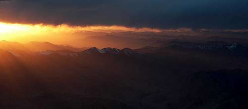
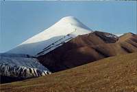
Sunset over Kunlun
In the local language Kunlun means: The mountains of blinding darkness.
The area is regarded as one of the toughest on earth. Here are some quotes from hard core travellers and mountaineers who have been to the area.
"It is probably the hardest area of the world to get to - Bill Tilman and I had hoped to get there but it is too far in"
Eric Shipton, about reaching the Arka Tag, one of Kunlun's sub-ranges.
"When on the plateau, my only thought is; Away, away, away from the Chang Tang."
Sven Hedin (on the Chang Tang Plateau, after crossing the Kunlun).
"Listen... do you really think I am so mad as to go back to the wastes in the north, where I already lost half of my caravan? Wherever we may go, I shall never go there!"
Sven Hedin. Caught by Tibetan police and told to go back the way he came. I.e. over the Chang Tang and the Kunlun.
I have climbed the highest mountains on earth, but the Chang Tang sucks me dry of all energy"
Rick Ridgeway, climber of K2, Everest etc. Comment about being on the Chang Tang Plataeu and crossing the Kunlun.
There is another Tibet, much of it above fifteen thousand feet, with treeless steppes and windswept ranges where only nomadic pastoralists with their herds of yaks, sheep, and goats can exist, and where there are vast tracts so barren that even they cannot survive. This is the Chang Tang.
George Schaller, National Geographic Society, 1997.
"Pouring rain, marshy ground, quicksand! Detestable! Again we had to negotiate a muddy range. Two tired camels were being led behind. One of them reached our camp. The other sank so badly into the mud on the top of the pass, that every effort to pull him out failed",
Sven Hedin About hardship in the Kunlun.
A few words about the page
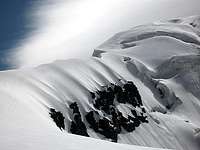
Kangzhagri
The Chang Tang peaks
Of course this page will mainly be about the Kunlun, but as the Chang Tang plateau, the northern uninhabited part of Tibet is the only way of approach to the Kunlun from the south, there will also be a lot about this fantastic place. The Chang Tang is known as The Last Wilderness and runs paralell to the Kunlun for about 2000km. Therefore I find it appropriate to integrate info about the area on the page.
It's not like any other place on earth and one day I may make a separate page about Chang Tang and the peaks there.
Kangzhagri and Zangser Kangri are included on the page. The former is part of a sub range of the Kunlun (Hoh Xil Shan), but the latter isn't. I choose to include them both as they are two of the main peaks of the Chang Tang.
Kunlun vs. Pamir
You find the peaks in the Chakragil and Kongur subsystems on this page. It may not be correct to sort any of these peaks under the Kunlun Range, but as the peaks in question are sort of in between the Kunlun and the Pamir and many people search for info about them under Kunlun, I have chosen to include them here anyway. The most correct sub-classification would be to exclude them from this page and add them to the Pamir page.
Main ranges
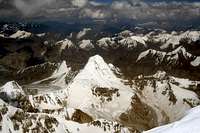
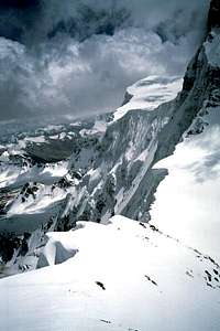
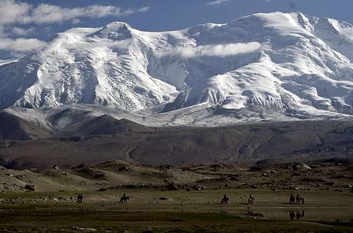
Part of Kunlun seen from 7500m
The Kunlun Shan is a major mountain system in Asia. If you count the central parts it’s about 2000 km long and inclusive the sub-ranges, it extends to almost 3000 km. That makes it the second longest range on earth, only second to Los Andes in South America. Kunlun is all situated in China, but the western part is very close to the borders of Tajikistan. This part is sometimes included in the Pamir mountain range, but nowadays the general consensus is it belongs to Kunlun proper.
If you follow the range eastward, it runs parallel to the Karakorams for a while and in one place only the deep Mazar Valley divides the two ranges. Further east the Kunluns splits in many smaller sub ranges. The long Altun Shan range in the north, which sharply rises from the Taklamakan desert, is the longest and it runs parallel to the Kunluns for almost a 1000km. It divides from the main range to the north-east from center of the Kunluns. The western part of Altun Shan is in turn sometimes called Kax Tax Shan. Most geologists agree this is not correct and consider Kax Tax a part of Kunlun, but not of the Altun Shan.
South of the Kunlun there are also some subranges. Possibly the most well known is the Hoh Xil or Kokoshili range, which is firmly located on the Tibetan Plateau. Arkatag, with its most famous peak Bukadaban (6860m) is one of the most eastern sub ranges. Other small ranges in the area include Yusupu Aleke Tagh, Qimantagh and Fuijian Shan. A lot of categorization can be done with this long and complex range, but the above mentioned are the main features of the Kunlun Shan.
High peaks in the range
Muztagh Ata, 7506m, the second highest peak in Kunlun
The range has about 200 peaks over 6000 meters and those are scattered all along the range. The highest are located in the most western extension, which sometimes goes under the name Kongur Shan. Kongur, at 7649m is the highest, but the most well known is Muztagh Ata at 7506m. The former is a tough and dangerous climb first climbed by Brits in 1981, while the latter is one of the easiest 7000 meter peaks. That has made it a popular target for mountaineers from all over the world. There are many side peaks of these two main mountains which reach over 7000 meters. Some are counted as separate mountains.
Looking east, the next peak over 7000 meters is to be found on the high Aksai Chin plateau. Most refer to the peak as just Aksai Chin I, Liushi Feng or Kunlun I. The Chinese call it Kunlun Godess. Its altitude is 7167 meters and was first climbed by a Japanese party in 1986. In the same area there are plenty of peaks over 6000m of which most are unclimbed. In the Kax Tax Range, Qong Muztagh is the highest at 6962m and was also first summited by Japanese mountaineers.
Yuzhu Feng, the highest in the SE.
In Altun Shan proper, Ak Tag is the highest at about 6700m. In central Kunlun, Ulugh Muztagh at 6973m is by far the highest. It’s difficult to put the most eastern high peaks in a certain sub range, but regardless of this, Bukadaban (6860m) is the highest and this peak is a part of the Arka Tagh. The highest peak in the Hoh Xil Shan is Kangzhagri.
In the extreme SE extension of the range Yuzhu Feng at 6179m is the highest.
Crossing the Kunlun
Early morning on Koskulak's NW ridge
There are few mountain ranges which have fewer passes than the Kunlun. Given the fact it’s such a long range, about 3000km, it’s amazing there are only two real roads crossing the chain. The crossing in the west is over the almost 5000 meter high Chiragsaldi Pass. It’s located on the Xinjiang Highway which links the Xinjiang Province with Xizang/Tibet. The other crossing point is Kunlun Shankou (see further down) on the Golmud Highway.
There are other more obscure places to cross the range, but at best these places are old nomad tracks or walking paths over high and windswept passes. The old trade route pass Kerriya Shankou (pass in Chinese), is a crossing of the chain east of the main Aksai Chin plateau. It is very high (5650m), the terrain is rough and the northern side of the pass is for walking only. Chairman Mao once planned to make a road through the Pulu or Aksu gorge, but failed badly, even with the help of thousands of POW’s. Atotam Daban, which is the next pass to cross using this alternative, is both high (5500m) and very steep.
Nadios, Martin Adserballe and I crossed this pass in 2002 and we were quite happy to make it out alive.
More about this further down.
Some modern day adventurers have managed to walk over a side pass of the Kerriya, namely a team of famous mountaineers (Ridgeway, Anker, Chin and Rowell) and two cyclists (Adserballe and Garnand).
Looking further east, there are some rough ways to cross the Kunluns close to Ulugh Muztagh and some mountaineering expeditions have done so in the last 20 years. The Karamiran Shankou was also used by Sven Hedin in the end of the 20’th century when he paid his first visit to the Chang Tang Plateau. Simmerer and Kauper, on their traverse of the Chang Tang crossed in this area and so did Adserballe in 2005.
There’s one more obscure place where a crossing is possible and that’s close to Yinyu Lake. The Kunluns are still high of altitude, but looks more like a long succession of sandy hills. "Nadios" and I crossed here in 2003.
The Kunlun Shankou is the only paved pass over the range and nowadays there’s also a railway line close by. The altitude of this pass is "only" 4700 meters and is the lowest of all crossing points, as well as the most used.
In the time of the great explorers, there were other crossing points, but most of these were one time onlys.
Climbing in the Kunlun
Kunlun can be sorted into categories according to which type of climbing you can find in the respective areas.
Kalaxong west ridge
Far west
The highest peaks. Some, like Muztagh Ata, Koskulak, Kuksay and others offers very high altitude, but straight forward climbing on snow. Kongur and basically all the other peaks in this sub-range of the Kunlun are of high technical difficulty and often with plenty of objective danger. North of these two groups Kingata Shan/Chakragil peaks is located. It can in general be considered as something in between Kongur group and the Muztagh Ata group in terms of difficulty, but the peaks are lower. All are below 7000m. This whole area has heavy glaciation, plenty of snow and easy access in common. The weather patterns are usually quite stable here.
The central parts
It's a huge area and it's hard to write something that goes for the full section of the range. From the south, you can approach the peaks from the Xinjiang Highway, which connects Kashgar and Lhasa. With the exceptions of the peaks close to the highway, they're hard to reach mountains. You're in for long hauls off road with land cruisers and the terrain may be very difficult. The climbing itself is usually quite easy peaks in the south, but rougher and more difficult the closer you get to the central parts. The main glaciated areas are found in the Dahongliutan area and the main Kunlun Ice cap, also known as Liushi Shan or the Kunlun Goddess area. It's here you also find Kunlun proper's highest peak.
The east
The main range is here split in many subranges. Most peaks are easy scrambles on scree and rock, but there are some exceptions with glaciated routes.
Wildlife
There are a few larger mammals living in the area.
Wild Yak, Chiru (Tibetan Antilope), Kiyang (Tibetan Wild Donkey), two kinds of foxes, wolf, bear, Tibetan Gazelle, lynx, Everman's polecat, marmot, Pika, Argali sheep and Himalayan blue sheep. There are plenty of bird of prey and at the large salt lakes a lot of different species of water birds can be found.
In the interior of the Chang Tang, south of the Kunlun the wildlife is rich and you see lots of animals all the time. Most of these animals have never seen a human being and treat the visitors with curiosity, indefference and a bit of nervousness.
Large parts of the Kunlun belongs to different national preserves and so does almost the whole of the Chang Tang Plateau, where all kind of hunting nowadays is strictly forbidden. In the late 80's in particular, corrupt officals who were stationed to protect the animals of the area, brought friends from mainland China for hunting. Machine gun hunting from jeeps were common and especially many Chirus were killed. Nowadays this crazyness has ended, but poachers are still out there trying to kill Chirus for its very expensive fur. The price a kg for this sought-after fur can amount to an astonishing $30 000. The penalty for illegal hunting is usually death.
Characteristics & climate
North side
The world's second largest (after the Sahara) sand desert is running all along the northern brink of the Kunlun. The climate is of typical inland characteristics. It's very far from any ocean and extremely dry and hot summers, with bitterly cold winters is the norm. The range doesn't get much precipitation and the snow line is very high, sometimes over 5000 meters. The extreme west, which has the Pamirs as a close neighbour further west and the Karakoram in the south, gets more snow and rain, but still it's a "dry range"
When travelling in the Taklamakan at altitudes of 900-1500m, you can see the Kunlun towering over you through the normally hazy skies. The elevation differencies is some of the largest in the world, up to 5000m in a very short horizontal distance.
Going south into the mountains, the desert quickly transforms in a couple of steps. Sand desert - gravel desert - dry valleys with huge sand hills - erroded mountains - high alpine peaks. Very little vegetation is found and the river beds are usually dry for most of the year. Flash floods are common in the melt off season and when torrential rains hit the area.
The vast plains of the southern side
South side
It's possibly the most inhospitable area in the world. See comments on top of page.
High altitude, in combination with very strong winds, very low humidity and extreme temeperature changes is the reason no one can live here. Not even the hardy nomads have had any settlements on the south side of the Kunlun.
The winter temperature can drop to -45C and in the summer daily temperature amplitudes can reach 55C (-25 at night and +30 in the day). Blizzards can strike at any time of the year. There's very little vegetation on this side. Some grass and a few species of plants are found.
Acess & logistics
From the north
Main range.
The one road, a modern version of the southern Silk Road, is the only access alternative to the range. It runs all along the northern side of the Kunlun. From there, there are lots of small dirt tracks leading into the mountains, but most of them are in a horrible condition and 4x4 or very sturdy trucks is a must. The hills are usually very steep and sandy (when not muddy). Sometimes the tracks becomes rivers when the area is hit by sudden, heavy rain storms.
It's not a question of if the vehicles will break down or get bogged down, but when. Bring sand mats, lots of spare parts, shovels and winches. Satellite communication gear is a must. Count on long periods until back-up and help can arrive from civilization.
The Kongur and Muztagh Ata area is different. Access is easy and you can travel on good asphalt almost to the foot of these peaks. See the Muztagh Ata page for a full description.

Access from the south
From the south
I don't say it's impossible, but no one has ever made it! With motorized vehicles that is, and that's what counts in this case.
The enormous Chang Tang Plateau effectively blocks all access. It's almost a 1000km of uninhabitated wasteland, without roads to deal with and rivers, mud, sand and mountain ranges will deter even the most intrepid expedition.
Those who're willing to risk it also have to think about other security considerations. If stuck out there, the time for a rescue team to reach you (if they can at all) may be weeks. There's no way to get help from a helicopter as in for example The Himalayas.
When to climb
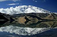
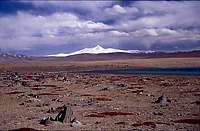
View from Karakol Lake
Most of the Kunlun recieves very little precipitation. The exception is the western end, where peaks like Muztagh Ata and Kongur are located. For those peaks and all the ones close by, the summer season is the best and the peak is July-August.
For the rest of the range, late fall is the preferred time of the year. That's when the late summer rains have ended and before it's too cold. Mud and flooding are the main reasons why the warmest period is a no-go option. There's also a short period in the spring when it's possible go reach the targets. That's after winter's melt-off and before the rains start.
It's possible to go in the winter, but intense cold makes it really hard and sudden blizzards can block the routes up to the mountains.
If you approach from the north, the only option is to go from late fall to early spring. Mud will stop all access at other times. Count on dealing with intense cold.
Costs & red tape
Normal Chinese peak fees are applied for all the peaks in the Kunlun Shan. For a peak in between 7000 and 8000m this is $1080. The permit can be split between 12 people officially and usually it's not hard to make a deal and include more climbers on one permit. If the peak is unclimbed, higher rates are applied.
The fee for a climbed peak below 7000m is $700 and below 6000m it's $30/climber. Unclimbed peaks usually come with a high price tag, 1000-5000$ is common.
The peak fee is not the expensive part though. The transport and the rest of the support is. Organizing a climb to the southern side will take an astronomical budget and may not be possible at all as the permits to go through the protected wildlife preserves can be very hard to get. Arriving from the north can be a quite cheap option, but only if the authorities agree on making it a light weight expedition. Demands on having a liaison officer, cooks, porters, lots of vehicles etc. is the norm.
The price list for peaks in The Xinjiang Province is officially as follows below. It's not corresponding completely to the fees given by the national organization and I must admit I'm not sure which rules apply in certain cases. Look at the given prices as approximations.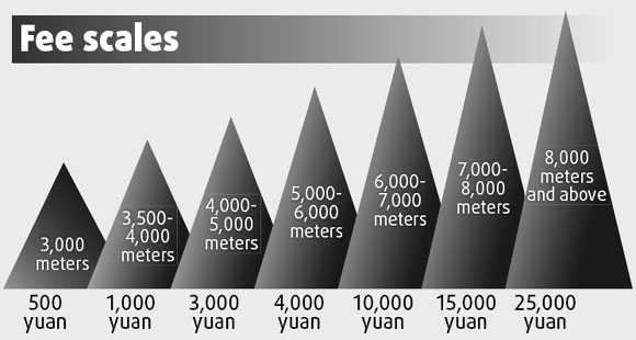
Crossing the Kunlun via Kerriya Shankou/PassBelow, some links leading to an expedition I participated in in 2002. Our plan was to cross the whole of the Chang Tang and we wanted a "warm-up". We were told we could go over the old trade route pass at Kerriya. No problem, the person said, you can cycle all the way over the Kunluns. Right. It was much tougher than we could ever had imagined and we actually had some very close calls on the way. After this trip we were way to wasted to go for the Chang Tang traverse.
On the expedition were three summitpost members.
Nadios, Martin Adserballe and I.
Martin's site - Introduction.
Martin's site - A photo story.
My site - Over the Kunlun.
Books & articles
- Arka Tagh by William Holgate.
- Sven Hedin: My Life as an Explorer.
- Sven Hedin: Trans Himalayas - 3 volumes.
- Wildlife of the Tibetan Steppe by George Schaller.
- Rick Ridgeway et al made a trip to the area. Read some of the National Geographic article on the www.
- The book about the same subject, by Rick Ridgeway.
- Douglas S. Mackiernan - CIA's first atomic spy was shot to death by Tibetans after a crossing of the Kunlun and the Chang Tang in 1950.
- Into Tibet - The CIA’s First Atomic Spy and His Secret Expedition to Lhasa, by Thomas Laird. A book about the subject.
Links
- The first ascent of Qong Muztagh. A good story and some maps and photos.
- A failed try on Kangzhagri. The Japanese expedition managed to summit the east peak. An expedition to one of the world's most hard-to-reach peaks.
- A site about Simmerer's and Kauper's crossing of the Chang Tang Plateau and the Kunluns.