

|
|
Mountain/Rock |
|---|---|
|
|
35.50528°N / 80.19472°E |
|
|
Hiking, Mountaineering |
|
|
19062 ft / 5810 m |
|
|
Overview
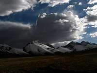 En route.
First I would like to start by saying that this page is extremely lacking in information. That is mainly due to the fact that Vulkan/Ka-er-daxi has very little information available on the internet, and apparently has never been climbed. I felt that the highest volcano in Asia deserved it's own page on SP!
 Google Earth image of Vulkan
Vulkan/Ka-er-daxi is an extremely remote volcano located in the Kunlun Shan on the Tibetan High Plateau in China. The volcano itself is comprised of 70 pyroclastic cones which make up the Kunlun Volcanic Group. The highest of these peaks is known as Vulkan or Ka-er-daxi, which rises to 5810m above mean sea level, making it the highest volcano in Asia! There was an eruption of one of these cones in 1951 that was witnessed by road building workers.
I have spoken with John Seach who is one of the worlds leading volcano adventurer's and he has confirmed that Vulkan is indeed a volcano.
More general information about Vulkan and the Kunlun Volcanic Group can be found HERE and HERE.
Vulkan is located in the extreme eastern part of the Aksai Chin area. At times when relations between India and China are rough, the area may be completely closed. A deal about this disputed territory seems to be on the negotiation table and hopefully closures of the area now belong to the past.
Getting There
Whichever way you choose, it's a very long journey to get to Vulkan. First you have to deal with long travels within the borders of China, most of the time on bad roads and in the end when you leave the Xinjiang Highway it's rough going in roadless territory.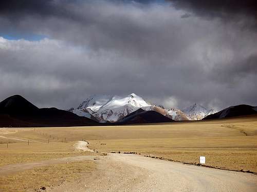 Travel on the Xinjiang Highway. Sirengou visible in the distance.
From Xinjiang - Kashi/Kashgar
Kashgar is an oasis town on the brink of The Taklamakan Desert. It has always been a transport hub and it's the last place where you can find flights and railway transport to.
From here there are basically two alternatives:
1. With a group in a rented (it comes with a driver in China, as foreigners aren't allowed to drive on their own) vehicle, usually a Landcruiser. Travel agents in Kashgar can arrange travel permits, a vehicle, a guide and everything else you may want or need.
2. Using local transport or hitching.
Take a bus to Yecheng/Kargalik. It's about 4 hours on good road and the cost is about $5-6.
Get a local bus to the little junction settlement of Aba. About 10-15min/$0.6-0.8
The bus station for transport towards the Aksai Chin area is located about 1km from the turnoff from the main road, on the left hand side of the main road leading towards your destination. The bus you have to take is heading for Ali/Shiquanhe, which is (at least!) a 30h ride from Aba. Ask for a ticket to Sirengou or Tianshui army base. It should be about $70-80. Count on at least a 24h journey. Tianshui is an army base in the beginning of the Aksai Chin Plateau. The soldiers may be friendly or they may not. It all depends on the orders they have been given and that in turn depends on the current situation in the area.
Sirengou is a small settlement at a lake. It consists of about ten ramshackle "buildings". You can eat simple meals, stay the night in extremely basic dorms ($1.2-2) and buy soft drinks, bisquits and noodles. Don't expect much of this place.
Hitching can be a bit tricky and the situation changes all the time. Sometimes foreigners are allowed to hitch, at others the truck drivers are told by the police they can't pick up hitchers. If you're lucky you can get rides for free, but most of the time you have to expect as much as the bus ticket costs. Bargain hard and ask different truck drivers before accepting a ride.
From Xizang/Tibet - Ali/Shiquanhe
First, getting to Ali is a long way from everything, about 1300km from Lhatse in central Tibet and about 1750km from Lhasa. Most travelers arrive in Ali by pre-arranged Landcruiser or by bus from Lhasa or Lhatse.
From Ali the alternatives are the same as from Xinjiang province. Arrange a Landcruiser, go by bus or hitch. Hitching is much easier from this direction to Sirengou than from the other side as there are no checkpoints and the truck drivers pick up hitchers much more often. The bus is about $20-25/7-10h.
The last part to Vulkan is a rough trek on very high altitude. The last 65km (direct line) have no tracks or roads. Leave the Xinjiang Highway close to Aksai Chin Lake and head ENE.
From the Xinjiang Highway to Vulkan
There's no roads or tracks leading to the peak from The Xinjiang Highway. From the closest point (direct line) from the road to the peak it's about 65km. The terrain is open and easy, but you have to get over one pass close to 5700m. It's not a long way up to the summit of the pass as the surrounding area already is at 5300m.
If you want to avoid the passes, the route to the peak becomes longer. A flat walk in is about 80km long and you'll stay below 5200m all the way to the foot of Vulkan. If you want to chose the latter alternative, leave the road west of the first Sirengou area peaks. This is also the eastern border of the Aksai Chin plateau proper.
Red Tape
This peak is to the best of my knowledge, unclimbed. If it is and the Xinjiang Mountaineering Association decides to follow the rules strictly, the peak fee will be 4400-10255$US! The peak is very small compared to its neighbors and you may be lucky and not charged at all for climbing it. Sometimes you can climb peaks below 6000m with no charge.The most expensive part of climbing this volcano would be the high costs of simply reaching the volcano itself.
 Map of Tibet, Coordinates of Vulkan
Camping & accomodation
Camping.You can camp everywhere in the area. Officially it's forbidden to camp in China, but no one cares. I have had many visits at my camp spots by both the police and the military and they have only been friendly and curious.
Accommodation.
The only places close to the peak is Sirengou village, a little truck stop with about ten shacks. A bed in a very basic dorm starts at ($1.2-2). It's a roof over your head, a bed and in some places a thermos of hot water included in the price. These places also have a restaurant part where you can eat cheap by western standards, but horrendously expensive by Chinese. Expect to pay about Y15-25/dish, which at the time writing is about $2- 3.5.
Tianshui, meaning "water from heaven" is an army base in the middle of the Aksai Chin plateau. You may be very welcome there at times, or you many not even get close to the base. I have experienced both. It all depends on the political situation. If you're lucky to be in the area when the situation is relaxed, you may be offered a bed and food in the base. They also have a small shop where you can buy some basic food, tobacco and military clothing.
When to climb
The area is of a very high altitude. All the surrounding areas are over 5000m and the Aksai Chin area is infamous for being a cold place. It's a place where a sudden blizzard can hit any time of the year and winter temperatures can drop below -40C. Therefore it's a good idea to attempt the peak in the warmest possible season. June to August is the summer months in the area. The nights can be very chilly even then and expect minus degrees on the summit. The unfiltered sun of high altitude can on the other hand almost fry you on a hot day. Be prepared for daily temperature amplitudes of at least 40 degrees even in the summer months.Altitude warning
If you arrive from Ali, you can skip this section.Leaving from the lowlands of Xinjiang at roughly 1500m above sea level, straight up to the high passes over the Kunlun can be extremely dangerous. First you cross two passes at about 5000m, then you drop a bit, but after that you're firmly on altitudes over 5000m. For an unacclimatized person this can be fatal. Best option is to get some acclimatization before departing from Kashgar. One good way is to spend some time trekking in the beautiful area around Muztagh Ata, which is located some hours away from Kashgar. Take this warning seriously!
Travelers have had to turn back to the lowlands, badly suffering from AMS and worse - some have even died on the journey towards Ali.
Be very certain you're fully acclimatized before leaving the main road. There's no easy way back and no help can reach you in time if you come down with altitude sickness in this area.
Preparation
MoneyBefore leaving any of the larger cities get as much cash in Renminbi/Chinese Yuan as you think you'll need. There are very few places in Xizang/Tibet and in the outback of Xinjiang which changes money and it's very far in between the ATMs.
Provisions
Buy anything you need before leaving the main cities. There are plenty of great supermarkets as well as smaller corner shops in China. You can find anything you can possibly need there. When you're on the Xinjiang Highway you're usually down to the choice of noodles, bisquits, soft drinks, powdered milk and candy.
Books & maps
BooksThere's no mountain litterature about the place. If you need a guidebook for general knowledge about traveling in the area, Trailblazer's Tibet Overland is one of the better. Forget about oh so famous Lonely Planet for this area. It's crap.

You'll see quite a lot of wildlife along the way, especially if you're hitching, and then it can be interesting to know what you see. A good book about the larger mammals in the area is George Schaller's Wildlife of the Tibetan steppe.

Maps
No mountaineering map of the area exists. The closest to a detailed map you'll get is either the Russian or American air force charts.
Maptown sells the American ONC and TPC. The Russian equivalents are more detailed and have more contour lines, but are harder to find. Omnimap has them all, but it's hard to buy separate sheets and I doubt you want to buy a set of 1643 sheets for $13072 :-). Please let me know if separate sheets are available somewhere on the www.
The overview maps of Tibet/Xizang and Xinjiang are usually horrible and full of errors. Some of the better is published by Gizi and Gecko, but be aware of that for example Sirengou isn't on it. Ok for planning, but not more. Gizi Xinjiang and Gecko Xizang/Tibet
External Links
Thanks to John for his helpful emails on the topic!