
|
|
Mountain/Rock |
|---|---|
|
|
42.29000°N / 19.54000°E |
|
|
8294 ft / 2528 m |
|
|
Overview
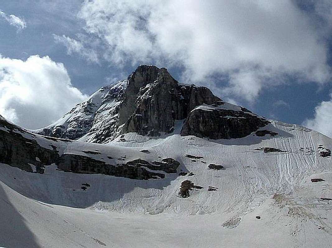
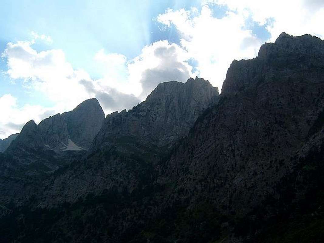
North Face of Kolac (Kolata, 2528 m) from Preslopit Pass (2130 m)
PROKLETIJE massif has many high and impressive peaks which with their beautiful outlook and amazing forms decorates incredible beauty of highest mountain range of Dinaric Alps. For sure, one of them is Kolac (Kolata, 2528 m), the highest peak of Montenegrin part of Prokletije and also of Montenegro.
This magnificent peak attract each year many climbers to climb it, specially in early and late spring, where snow is stil on the mountain, which offer enjoyment in some kind of climbing in winter conditions. Actually, Kolac massif has two peaks - Dobra Kolata (2528 m) and Zla Kolata (Kolata e Keq, 2534 m). Both peaks are placed in Montenegro/Albania border area, but they belong to Montenegro.
Kolata - Kolac peak is known as peak with many amazing summit panoramas. From them, two are most attractive - view to massif of Maja Jezerce (2693 m) and view to beginning of amazing Ropojana Valley. View to Maja Jezerce is little beat different than from Maja Rosit summit (different side of view), while view to Ropojana Valley is more open than from Maja Rosit summit. Also, similar like from Maja Rosit summit, from Kolata - Kolac summit you can enjoy in amazing view to giant massif of Majet e Zabores Group (Zabores e Krasnices) which is 13 km long! Whole this long and amazing massif can be seen from Kolata - Kolac summit! Between the peaks of Majet e Zabores Group specially dominates Maja Hekurave (2561 m), Maja Grik e Hapt (2625 m) with it's 500 m high & 300 m wide North Face, and Maja Briaset (2567 m) with it's 900 m high & 900 m wide impressive wall, one of the bigest in whole Prokletije massif.
LOCATION:
Kolata - Kolac (2534 m, 2528 m) peaks are placed on E from Maja Snikut (Nikacki Vrh, 2554 m), Maja Rosit (2525 m), Maja Skurt (2499 m), Karanfili (2460 m, 2490 m, 2441 m), Maja Lagojvet (2466 m), Maja Vukoces (2450 m), Forca (2340 m), Vojusit (2210 m), Popadija (2057 m), Volusnica (1879 m), on W from Maja Desles (2403 m), Valbona Valley, on N from Maja Jezerce (2693 m), Maja Popluks (2569 m), Kokervhake (2508 m), Maja Ragomit (2472 m), Maja Alis (2422 m), on S from Visitor (2211 m), Mt Bor, Gusinje town and Vusanje village, on NE from Maja Grik e Halt (2625 m), Maja Radohines (2570 m), Maja Brijaset (Brijac, 2567 m), Maja Hekurave (2561 m), Majet e Zabores, Maja Malisores (2490 m), Maja Shchokishte (2461 m), Sev i Barde (2252 m), on NW from Maja Haruses (2424 m) and Maja e Pecmaras.
SUMMIT VIEW:
E: Maja Desles (2403 m), Valbona Valley
W: Maja Snikut (Nikacki Vrh, 2554 m), Maja Rosit (2525 m), Maja Skurt (2499 m), Karanfili (2460 m, 2490 m, 2441 m), Maja Lagojvet (2466 m), Maja Vukoces (2450 m), Forca (2340 m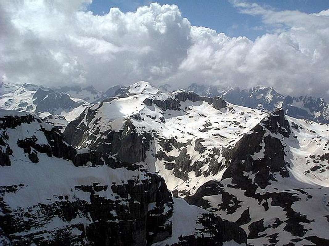
Prokletije massif from Kolac (Kolata, 2528 m) summit
N: Visitor (2211 m), Mt Bor, Gusinje town and Vusanje village
S: Maja Jezerce (2694 m), Maja Popluks (2569 m), Kokervhake (2508 m), Maja Ragomit (2472 m), Maja Alis (2422 m)
SW: Maja Grik e Halt (2625 m), Maja Radohines (2570 m), Maja Brijaset (Brijac, 2567 m), Maja Hekurave (2561 m), Majet e Zabores, Maja Malisores (2490 m), Maja Shchokishte (2461 m), Sev i Barde (2252 m)
SE: Maja Haruses (2424 m), Maja e Pecmaras
 |
 |
 |
 |
Routes Overview
Route: Vusanje (1060 m) - Zarunica (1240 m)(T2) 1h - Grlata (1810 m)(T2) 2h - Preslopit Pass (2130 m)(T3) 1h - Dobra Kolata Peak (2528 m)(T3) 2h - Zla Kolata (2534 m)(T3) 30 min
High difference: 1474 m
Lenght: 12 km
Duration: 6.30 h
Marked trail
ROUTE DESCRIPTION:
Route start from Gusinje town. The village of Vusanje (1060 m) is in the Ropojana Valley, by a narrow asphalt lane. The beginning of this trail is at an army barracks. From there go east, ascending through the little village of Zarunica, to the Grlata katun (shepherd hut), by the carriage road. Continue on the pasture trail south towards the start of the lower Preslopit Pass (2130 m), entering the narrow gorge. By either side of this passage is the upper part of Preslopit. 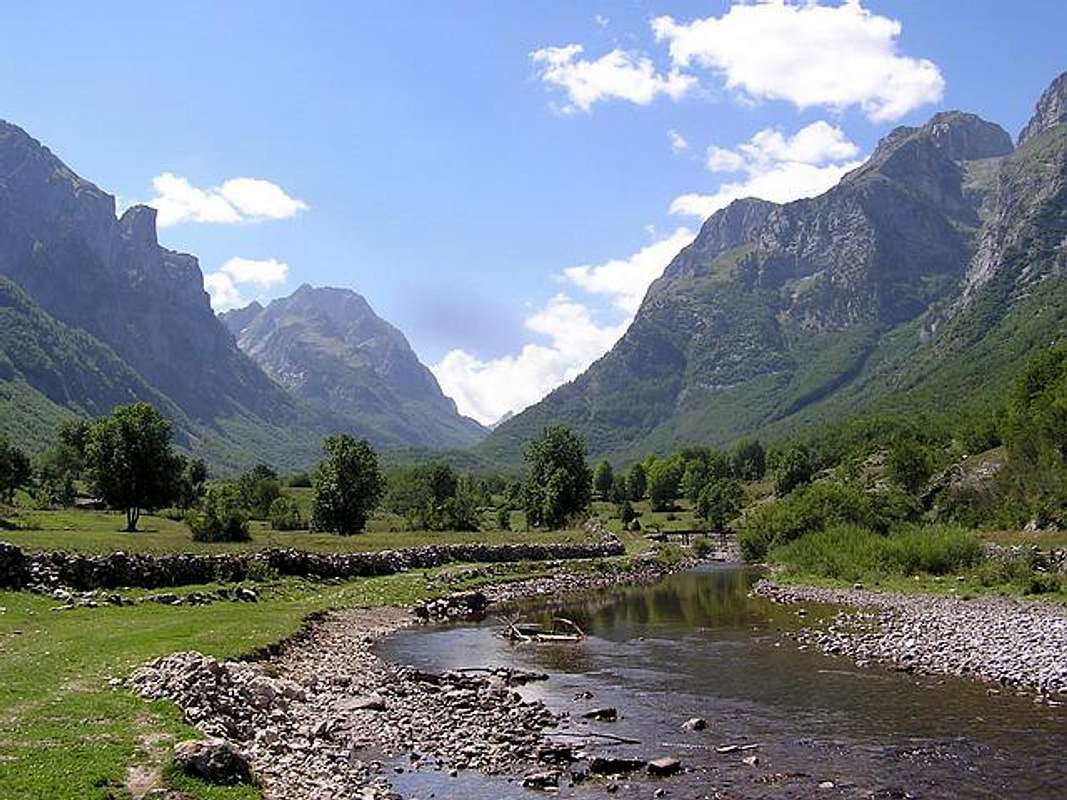
Ropojana Valley in Montenegrin part of Prokletije
From there go toward the distant yet recognizable trapezoid form, through the Dvojni Prevoj (Double Pass, 2430 m) which is located at the foot of Kolata - Dobra Kolata & Zla Kolata. From there, the ascent goes along dangerous steep, exposed and grassy slopes, to easier terrain of grassy steppes and rocky plates. From Kolata (2528 m) summit, use the ridge on the Albanian territory, easily passing to the Zla Kolata (Kolata e Keq, 2534 m), which is 6 m higher. Those two peaks are the highest peaks of Montenegro. The third highest peak is Maja Rosit - Rosni Vrh (2525 m). But officially, the highest peak of Montenegro is Bobotov Kuk (2523 m), highest peak of DURMITOR massif. Reason - Durmitor is situated in the hearth of Montenegro and is closer to the heart of Montenegrins, while Kolata is placed on border with Albania.
 |
 |
 |
Getting There
Gateway to Prokletije and Kolata - Kolac (2534 m, 2528 m) peaks are Plav town and Gusinje town and then Vusanje village. Information how to get there:
By Plane
~To Beograd (Belgrade, Serbia&Montenegro capital) airport. Than with plane to Podgorica, capital of Montenegro, or with bus or car to Plav town.
~To Podgorica airport. Than with bus or car to Plav town and after to Gusinje town.
Information about flights find on the sites of JAT Airways, a former Yugoslav airlines, or on Montenegro Airlines.
By Bus
~Beograd (Belgrade)-Plav
~Podgorica-Plav
By train
~Beograd (Belgrade)-Bijelo Polje. Than with bus or with car (rent a car) to Plav and Gusinje. Finally, to Vusanje village.
By car
~Beograd (Belgrade)-Kraljevo-Novi Pazar-Plav-Gusinje.
~Podgorica-Kolasin-Andrijevica-Plav-Gusinje
Gusinje town and Plav town (in Montenegro) are the main destinations you would head first. In Gusinje you can buy everything (food, shampoo, soap, clothes,... and many other things), all what you need for few days of trekking and climbing in heart of Prokletije massif.
From Gusinje town deeper in Prokletije massif till Vusanje (1060 m) village. Distance: Gusinje - Vusanje: 7,5 km, (2 h of walking with big rucksack (backpack).
 |
 |
When To Climb
Kolac (Kolata, 2528 m) from Rosni Vrh (Maja Rosit, 2525 m)

Below Kolac-Kolata
June - September are the best period for climbing of two summits of massif of Kolata - Kolac (2534 m, 2528 m). In June and July also, you will find snow area on some places, specialy on north side of massif. Don't worry, snow is hard. Like in many mountains, you will see full lakes from April till July. If you want to take a photos of lakes, better come in this period, because the lakes are full and snow is still on the peaks which Jun or July is the best for this. If you will come earlier, take with you everything from mountain equipment, which you will need in winter or spring time.
 |
 |
Camping
Also, you can rent rooms in Plav & Gusinje towns and Vusanje village and stay there. For orientation - from Gusinje till Vusanje village is 7 km distance. By car - 10 minutes on asphalt road, by walk with big rucksack - 2 hours.
On the end of Ropojana Valley exist hut Ropojanski Zastan where you can stay before and after climbing of Kolata - Kolac (2534 m, 2528 m). That's the nearest camping place, but still 4-5 h by walk far from the Kolata mountain. The best camping solution is to stay in your personal bivouac belowe Kolata massif, somewhere in Ropojana Valley.
Also, exist chance to make a deal with shepherds who offer a place in their huts. Try it and let yourself be surprised. Most of the wayside restaurants can offer accomodations over night, you just have to ask "prenochishte" (stay over night). Camping is not allowed but not controlled regularly.
 |
 |
Mountain Conditions
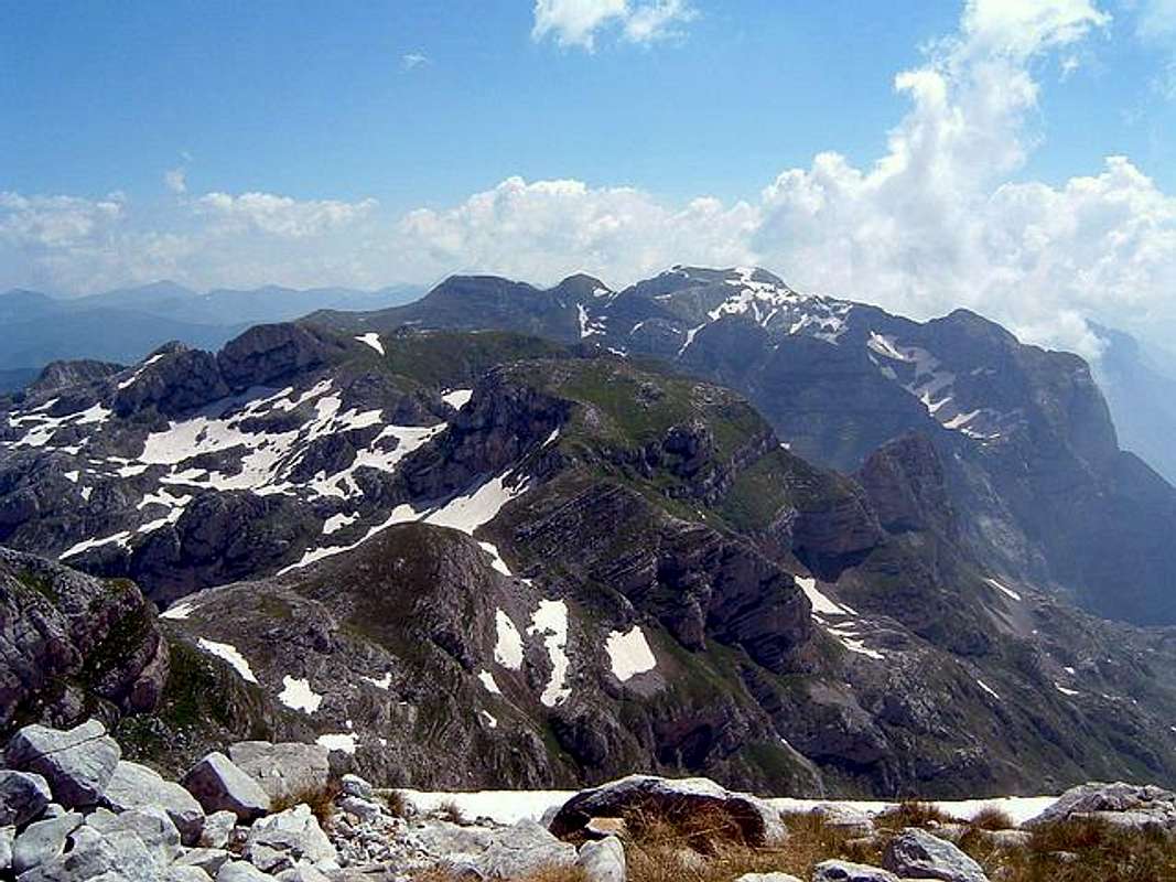
Prokletije peaks above Ropojana Valley
The best local weather forecast (4 times daily) for Prokletije (Plav town) on VREME YUBC NET
 |
 |
Red Tape
You're in Montenegro-Albania border area and you must before your climbing of Kolata - Kolac (2534 m, 2528 m) peaks just to contact the Border Security Department in Plav town. For the visit of certain (Albanian) parts of the range, where is highest peak of Prokletije massif - Jezerski Vrh/Maja Jezerce/Lakes Peak (2694 m) and beautiful Lakes Valley with few glacier lakes, you must get a special military permission in the Border Security Department in Plav town.
 |
 |
mullinge - Feb 18, 2013 3:44 pm - Hasn't voted
Kolata CoordinatesHi, We climbed Zla Kolata last summer and found that the GPS coordinates listed on the Kolata summitpost page are incorrect. I took a GPS position from the Zla Kolata summit in 2012: N: 42.48496 E: 19.89627 All the best, Neil