
|
|
Mountain/Rock |
|---|---|
|
|
42.44280°N / 19.81230°E |
|
|
Mountaineering |
|
|
Summer |
|
|
8428 ft / 2569 m |
|
|
Overview
 The massif of Maja Popluks (2569 m)
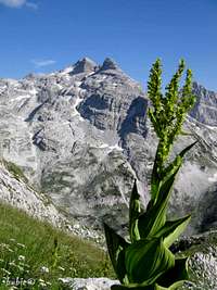 Maja Popluks
The massif of PROKLETIJE (BJESHKET E NEMUNA) stretches on the territories of the three countries - Montenegro, Serbia (Kosovo area) and Albania. Actually, that incredible range is a natural border between these three countries. The highest peaks of that range are placed in Albanian part of massif. One of them is Maja Popluks (2569 m)(Maja e Popljuces, Pop-Lukin vrh). That beautiful peak is one of the closest neighbour of the highest peak of Prokletije (Bjeshket e Nemuna) range Maja Jezerce (2694 m)(Jezerski Vrh). Maja Popluks proudly dominates above beautiful Valbona Valley, which is for sure one of the most wonderful valley of that range.
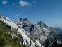
Maja Popluks is surrounded by many impressive peaks as are Maja Jezerce (2694 m), Maja Hekurave (2625 m), Majet e Zabores (massif with 10 peaks above 2400 m), Maja Briaset (2567 m)(Brijac), Maja Shnikut (2554 m)(Nikacki Vrh), Maja Radohines (2570 m), Maja Livades (2496 m) and Maja Malisores (2490 m)(Malisorski Vrh). Also, it's neighbourhood is enriched by amazing Valbona Valley.
Summit View
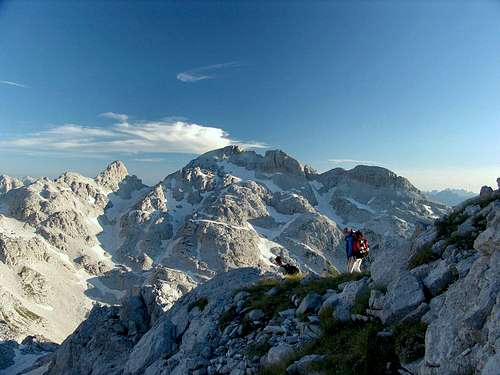
 Maja Popluks (2569 m) from Qatat e verlla false summit
The summit of Maja Popluks (2569 m)(Pop-Lukin vrh) offers many beautifully summit views and panoramas. Three are most impressive - view to Maja Jezerce (2694 m) , to Maja Hekurave (2625 m) & Maja Briaset (2567 m)(Brijac) and to Valbona Valley.
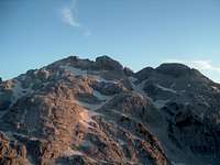
 Maja Popluks from Maja Jezerce summit
N: Maja Jezerce (2694 m)(Jezerski Vrh)
N-NW: Maja Malisores (2490 m)(Malisorski Vrh)
NW: Maja Shnikut (2554 m)(Nikacki Vrh)
NE: Maja Ragomit (2472 m)
E: Maja Hekurave (2625 m), Majet e Zabores (massif with 10 peaks above 2400 m), Valbona Valley
SE: Maja Briaset (2567 m)(Brijac)
S: Thethi Valley
SE: Maja Radohines (2570 m), Maja Livades (2496 m)
Routes Overview
Theti Valley-Qafe Pejes route to Maja Popluks (2569 m). Thethi-Qafe Pejes route - Part II
 Thethi-Qafe Pejes route - Part I
Getting There
 Descent with Maja Popluks (2569 m) in the background
Approaching to Maja Popluks (2569 m) you can choose between the two appraoches - from Montenegro and from Albania. The approach from Montenegro is more convinient.
FROM MONTENEGRO:
 Ropojana Valley
 Maja Popluks
Gusinje - Vusanje - Ropojana Valley - Zastan hut - Buni e Jezerce valley - Qafa e Pejes pass - The heart of Albanian massif - Maja Popluks
Gateway to Prokletije and Maja Popluks (2567 m) are Plav town and Gusinje town and Ropojana Valley. Information how to get there:
By Plane
~To Beograd (Belgrade, Serbia&Montenegro capital) airport. Than with plane to Podgorica, capital of Montenegro, or with bus or car to Plav town.
~To Podgorica airport. Than with bus or car to Plav town and after to Gusinje town.
Information about flights find on the sites of JAT Airways, a former Yugoslav airlines, or on Montenegro Airlines.
By Bus
~Beograd (Belgrade)-Plav
~Podgorica-Plav
 3 summits of Maja Popluks (2569 m)
By train
~Beograd (Belgrade)-Bijelo Polje. Than with bus or with car (rent a car) to Plav and Gusinje.
By car
~Beograd (Belgrade)-Kraljevo-Novi Pazar-Plav-Gusinje.
~Podgorica-Kolasin-Andrijevica-Plav-Gusinje
Gusinje town and Plav town (in Montenegro) are the main destinations you would head first. In Gusinje you can buy everything (food, shampoo, soap, clothes,... and many other things), all what you need for few days of trekking and climbing inside of Prokletije massif.
From Gusinje town you can go deeper in Prokletije massif through the Ropojana Valley (with entry permit of montenegrin and albanian police which you get in police station in Gusinje town).
FROM ALBANIA:
 Maja Popluks from Qafa Pejes pass
 Thethi Valley
 Boga Valley toward Thethi Valley
 From Maja Jezerce
 Maja Popluks from S
1. S-SW approach (by car):
-Tirana (Albania capital-Mother Teresa International Airport)-Shkoder: 116 km, asphalt road.
-Skhoder-Koplik:18 km
-Koplik accross the Qafa Thores pass (important connection between major glacial valleys, Boge north, Shala south, Valbona east, and gateway for the Thethi valley: 80 km of macadam road. Very difficult road for driving.
-Thethi Valley-Qafa e Pejes pass-Maja Popluks (2569 m)
2. Qafa Shilahut pass (Shkoder-Prizren road), then turn left for Fjerze, over the bridge accross the Drin river to Bajram Curri and further till Valbone at the end of the Valbone valley. Qafa Shilahut-Valbone: 80 km of macadam road.
Camping
 Ropojanski Zastan hut
If you are approaching Maja Popluks (2569 m) from Montenegro, you can stay in Ropojanski Zastan hut on the end of Ropojana Valley, near Montenegrin/Albanian border. Ask in Gusinje town and in Plav town for getting the key of that hut. If you approaching Maja Popluks from Albania, you can freely use your tent in Boga Valley, Thethi Valley and also inside the massif of Albanian Prokletije, at the foot of Maja Popluks.
Maps
 Maja Popluks area
 Prokletije map
Red Tape
 View to Maja Popluks
You're in border country and if you approaching Maja Popluks from Montenegro will have to ask for military permits to visit certain (Albanian) parts of the range, where is highest peak of Prokletije massif - Jezerski Vrh/Maja Jezerce/Lake Peak (2694 m) and Maja Popluks (2569 m). Entry permit you can get in the police station in Gusinje town and in the Plav town.