
-
 8731 Hits
-
 85.36% Score
-
 20 Votes
|
|
Mountain/Rock |
|---|---|
|
|
46.43883°N / 14.29871°E |
|
|
Hiking, Scrambling, Skiing |
|
|
Spring, Summer, Fall, Winter |
|
|
6457 ft / 1968 m |
|
|
In Slovenian language č, š and ž are pronounced like ch, sh, and zh. Our mountain is written Košutica.
Overview
 From the north
 Climbing the N rib
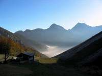 Bor - From above Zelenica
As on many places in Karavanke / Karawanken, also naming of mountains around Ljubelj / Loibl pass is not well defined. Our mountain is in Slovenian language also named Ljubeljska Baba, or only Baba. Košutica is a name of Slovenian people in Koroška / Kaernten. On the southern side of the border the mountain is also called Korošica, which made Austrians to translate it into Kaerntnerin.
Not being among the most prominent peaks of Karawanks, Košutica / Loibler Baba is stil a nice and quite popular mountain. From the west, from the southern portal of the road tunnel, it has a shape of a nice cone peak, while towards the north it shows a rugged rocky wall with two distinct peaks above it. The summit stands in the main ridge of Karavanke / Karawanken, between Ljubelj / Loibl pass and the long crest of Košuta / Koschuta. From the latter it is separated by a distinct saddle - Hajnževo sedlo / Hajnžsattel, while towards Ljubelj / Loibl it sends a long, mostly grassy western ridge.
The majority of visiters ascend on Košutica / Loibler Baba from the SW, from the Slovenian side, but also the approach from the Austrian side is often used. It is primarilly a hiking mountain, the short N wall is not appropriate for harder climbs. In winter and spring high on the mountain, if not on the top, tour skiers ascend. And the broader northern area would be also very appropriate for mountain bikers, if almost all the roads were not prohibited, not only for cars but bikes also. It is obvious that farmers there value high their solitude.
In the vicinity there are a few lower summits, mostly already overgrown with vegetation. Yet, Lokovnikov Grintovec / Grintoutz, 1809 m, just north of Košutica / Loibler Baba, is stil a nice panoramic summit, worth of visiting. East of it stands a bit lower Praprotnik / Zeller Prapotnik, 1727 m and the officially 1614 m high (probably it's a bit higher) bump in the western ridge of Košutica / Loibler Baba is called Rjava peč. For the land north of Košutica / Loibler Baba forested round-hilled ridges are characteristic and between them quite deep valleys through wich lively creeks are flowing. One such ridge goes towards the north from Rjava peč, until on Oselca / Eselsattel it attaches on the neighbouring massif of Grlovec / Ferlacher Horn. The second ridge continues towards the north from Lokovnikov Grintovec / Grintoutz. Between these two flows Žerjavski potok / Žerjavbach. The third ridge goes from Praprotnik / Zeller Prapotnik towards the NE. West of it is Majerov graben / Maiergraben, and east of it Hajnžev graben / Hajnžgraben, which separates the whole area from the long and much higher Košuta/Koschuta crest. On the slopes and saddles of these hills there are many idylic, stil alive mountain pastures, while all the farms are on the northern side of the area.
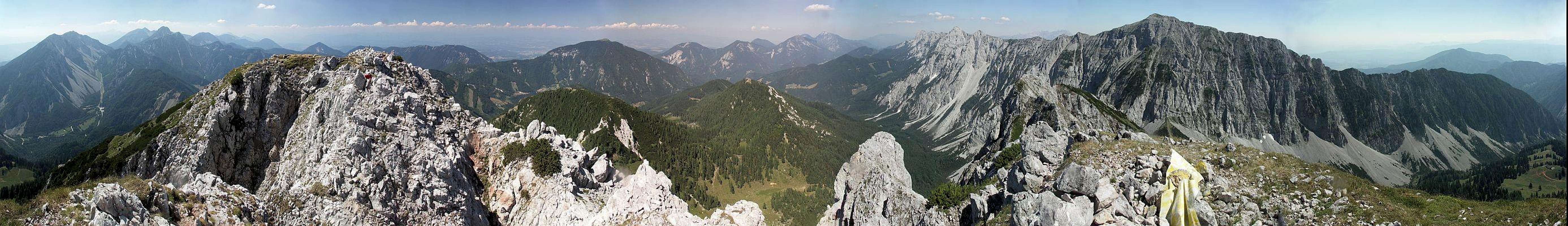
Summit View
From Košutica / Loibler Baba the view is open towards the north and is similar as the view from the rest of Karawanks. What is specific, is the nice view along the long, rocky crest of Košuta / Koschuta, and the interesting view towards the highest part of Karawanks around Stol / Hochstuhl, Vrtača / Wertatscha and Begunjščica.
Getting There
The southern and western approaches start on the Ljubelj / Loiblpass road, by the southern portal of the tunnel or on two points 50 and 100 altitude meters lower.
For the northern approaches one needs to arrive first into the valley of Waidischbach / Bajdiški potok. It can be reached either from Ferlach / Borovlje (by the main Ljubelj/Loibl road), from Eisenkappel / Železna Kapla over the saddle Schaida / Šajda or from the north along the valley of Freibach / Borovnica. In the main valley and around its tributaries many villages with the common name Sele / Zell lie. We can reach either the parking place at the end of Sele - Zvrhnji kot / Zell - Oberwinkel (or the nearby Lokovnik farm), either Sele - Srednji kot / Zell - Mitterwinkel, where we can park by Škrbina / Skarbina inn. Other approaches are longer for a few kilometers and they use paths and forest roads between the mentioned two.
Routes Overview
Many routes, marked and not marked, reach the area of Košutica / Loibler Baba. They are all hikes-up, of different difficulties, but none of them really an entirely easy one. Just below the top on all of them are a few passages, where a safe step is needed. The ascent over the north rib is a marked hike-up, but so poorly protected that it is already in the range of an easy climb of degree UIAA I.
2. Over the Korošica pasture.
It's a nice, high alpine meadow, 1554 m, with a hut where you can often also get food and drink. It's reachable from the Ljubelj road in 2 h. From Ljubelj / Loibl road (Slovenian side) we can start either on the altitude of 1050 m or 950 m (parking places by the road). The upper path brings us on the meadow across the slopes of Grunt, while the lower path follows the cart-road through the valley below Zajmenove peč. That valley ends above on the Hajnževo sedlo / Hajnžsattel, but on the altitude of some 1350 m we leave it and ascend by a good path towards the N on the Korošica meadow. The private hut there is usually open. From the meadow we continue northwards, branch right and across the slopes reach the western ridge. Then, as described above in #1, go by it on top. A medium hard hike-up (T3 just below the summit), 1000 m of altitude difference, 3 h.
 JFS - Veliki vrh JFS - Veliki vrh |
 On the W ridge On the W ridge |
 On the W ridge On the W ridge |
 On the east ridge
 Seen from the E
3. From the Hajnževo sedlo / Hajnžsattel.
The saddle can be reached either from the SW (Slovenian side) or from the NE (Austrian side). The Slovenian ascent route is the same as the above mentioned ascent on Korošica meadow, but we continue by the valley up on the saddle (this last section is unmarked). We can also reach the saddle from the Korošica hut.
The tour from the Austrian side is done from the Hajnž farm (abandoned), 995 m, or from Škrbina / Skarbina inn, 1035 m (30 min further). We go up the main valley below the northern walls of Košuta / Koschuta, the path is marked till the crossroads on some 1320 m. There we leave the marked path and continue over the screes in many switchbacks on the saddle. Till there from both sides some 2 h 30 min (from Škrbina / Skarbina inn 3 h). We can reach the saddle of course also from Korošica meadow, but it's a detour.
The route from the saddle on the highest point was once well marked and maintained (secured), today it's much abandoned. First it goes up, then left on the scree field, up by it and then by steep grassy slopes a bit towards the left on the eastern summit. The notch between the two summits requires a few meters of easy climbing, but the rock is good. The whole route is a demanding hike-up (easy to the saddle (T4), exposed on a few places. To go on top from the saddle all the time by the ridge is less recommendable, because it is narrow, crumbly and exposed.
 Košuta
 On Lokovnik pasture
4. Over the Dovjakovo sedlo / Dovjaksattel.
These are the Austrian ascent variants. The saddle N of Košutica / Loibler Baba, between it and Lokovnikov Grintovec / Grintoutz, can be reached by numerous paths. They are all quite long:
a. From the Hajnž farm (abandoned), 988 m, or from Škrbina/Skarbina inn, 1035 m (30 min further). As above in #3 towards Hajnževo sedlo / Hajnžsattel, but on the crossroads on 1320 m we continue by the marked path towards the right (N), in 5 minutes to the water source in the forest, where we turn sharp left and go westwards. We can ascend Dovjakovo sedlo / Dovjaksattel directly, but the marked path goes right first on the saddle between Lokovnikov Grintovec / Grintoutz and Praprotnik / Zeller Prapotnik, and then across the grassy slopes on Dovjakovo sedlo / Dovjaksattel. Some 2 h 30 min till here (from Škrbina/Skarbina inn 3 h).
b. From Lokovnik farm, 920 m. The farm lies on a nice terrace above Sele - Zvrhnji kot / Zell - Oberwinkel. Around the hill above the farm we go by the western side, ascend on the forest road, which then leads us across the slopes, on Konjak hill, 1406 m, around Petrovec hill, 1506 m, where it ends (in 2008). By a good path we are in a few minutes on the idyllic mountain pasture - Lokovnikova planina / Vokovnikalm, 1540 m. From there we continue southwards around Lokovnikov Grintovec / Grintoutz, and on the ridge (saddle) between it and Praprotnik / Zeller Prapotnik hit the marked path, which comes from Hajnž farm. Then right by it on Dovjakovo sedlo / Dovjaksattel. Some 2 h 30 min, nice hiking over the pastures!
From Dovjakovo sedlo / Dovjaksattel the main marked path continues crossing below the N wall of Košutica / Loibler Baba towards the west. It descends first a bit, then crosses the slopes horizontally and finally reaches the W ridge on the point 1673 m. Then as described above under #1, by the W ridge on top. Altogether it's some 3 h 30 min hike, easy all the time, except just on top.
 The route over the N rib
 Above žerjav creek
There's also the third approach from the valley of Sele - Zvrhnji kot / Zell - Oberwinkel. From the parking place at the end of the valley, below Žerjav Farm we continue by the mountain road through the valley of Žerjavski potok / Žerjavbach upwards. The road is very long and winding, would be ideal for biking! So we reach the pasture W of Dovjakovo sedlo / Dovjaksattel, from which we directly ascend on the W ridge of Košutica / Loibler Baba (shepherds paths), and then on top. Also 3 h 30 min.
And finally the sweetest, but hardest hiking variant - by the N rib. Why going from Dovjakovo sedlo / Dovjaksattel so much around? The N wall of Košutica / Loibler Baba has in the middle, just above the saddle, a less demanding rib, which enables a relatively easy ascent. In the lower part we go by a week path, when we cross the fence on the saddle we welcome also red marks (arrows), so don't worry continuing. From the entry into the rocky face till the top we have an easy climb, degree UIAA I, but well marked. We see an old iron peg or two in the rocks and some more deposited aside, which makes us think they will be missing in the rocks. But climbing is really easy, for a bit more than 200 m we need less than 40 minutes and here is the top. You can see a detailed map (1:50.000) on-line on:http://www.austrianmap.at/.
Red Tape
No limitations. Forest roads and local roads are closed for public traffic (see the embedded map).
Mountain Huts
Nothing which could be used, but the ascent is anyway less than a one day tour. Koča na Ljubelju is more a kind of a restaurant. On alpine pastures, you can possibly get some food and drink (for example on Korošica), in farms on the northern side you can probably also get some service.
When To Climb?
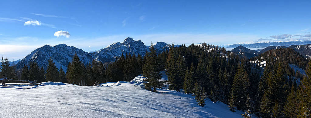
 haubi - Winter ascent
 haubi - Winter
Košutica / Loibler Baba can be ascended in all seasons, but winter ascents (or in snow) require also winter equipment - ice axe and crampons. Due to steep slopes, skiing is best done in spring, the exception is the ski tour only from Hajnževo sedlo / Hajnžsattel. It can be done safely also in winter, but not when there is a lot of fresh snow (because of possible avalanches, coming down from Košuta / Koschuta walls).
The first time we ascended Košutica / Loibler Baba in a bad weather, so on the whole crossing we saw almost nothing. Then we came once in winter - in a perfect day, but without any equipment. An easy ascent to the west ridge, but there snow became very hard. In several consecutive days melted and frozen again. The slopes became steeper and steeper, no help of pine-bushes, which are there abundant in summer, so we turned around on the middle of the ridge and descended without summiting. Then again we came in a nice, fresh snow with skis on the Hajnževo sedlo / Hajnžsattel. We first thought of going towards the top (at least some of us), but a strong wind and a party of returning Austrians convinced us not to do so.
Your Help Needed
I'd appreciate if you have any information of the following:
- Any rock climb route from the north?
- Any picture of a real skiing from the summit?
- Were you on Praprotnik / Zeller Prapotnik?