
-
 7602 Hits
-
 79.04% Score
-
 10 Votes
|
|
List |
|---|---|
|
|
Why This List?
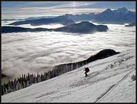
Skiing from Baba
Routes can and should be described on separate pages, I know. But that is worth doing only for major routes, which need a description. However, there are many simple tours which are described on mountain or area pages with one or two sentences. But they might still be a goal for a nice day. So here I'm providing a comprehensive list of all ski tours in the Karawanks.
Yet, on the list there are only ordinary ski tours. Alpinistic descents, so the ski tours of degree D (difficult) and higher are not included.
For the grading, the Swiss Ski Tours Grading Scale is used. In its lower part the grades are:
| F - Easy (Facile) | PD - Less difficult (peu difficile) | AD - Quite difficult (assez difficile) | D - Difficult (difficile) | ||||||||
| F | F+ | PD- | PD | PD+ | AD- | AD | AD+ | D- | D | D+ | |
Karavanke/Karawanken - A Ski Touring Paradise
Bor Sumrada: On Pusti rovt
Only in highest regions Karavanke/Karawanken are steep and rocky, and so unappropriate for tour skiing. And that holds more or less only for northern slopes. All the highest summits can be skied down from the very top, but some ski tours are already alpinistic, requiring perfect conditions and the full mastery of skiing technique. Then comes the majority of Karavanke/Karawanken summits - rounded, not too steep, offering great panoramas, especially on Julian Alps. This is the paradise I'm talking about. Goals, appropriate for almost the whole skiing season, some of them also in a hard winter.
Stretching some 120 km in the West-East direction, Karavanke/Karawanken look very different from the southern and the northern side. The southern side is more grassy, opened, fine for skiing if snow conditions are good (not too late). The northern side is rocky on higher regions, through rocks some fine couloirs are cut, then some steep scree slopes come and then forrests, through which a network of forest roads is cut.
Ski Tours List
Peč / Ofen / Monte Forno
|
Summit
|
Ski Tour
|
Alt. diff.
|
Ascent hrs
|
Grade
|
Comment / Description
|
|
Peč, 1510 m
Petelinjek, 1552 m |
N slopes |
880 m
|
2:45 h
|
F
|
Ordinary ski terrains, ski-lifts.
|
| Peč, 1510 m |
W route | 550 m | 2:30 h | F+ | From the Poscolle localita, it's a long walk through the woods, mostly by gently ascending forest roadsje. From the bivouac up, a bit steeper ascent/descent. |
| Peč, 1510 m |
S route | 630 m | 2:30 h | F+ | A mountain road reaches the summit, but the upper part (above the Dom Tromeja) can also be done by a direct variant, cut through the wopods. |
Vošca and the Trupejevo Poldne Group
|
Summit
|
Ski Tour
|
Alt. diff.
|
Ascent hrs
|
Grade
|
Comment / Description |
| Kamnati vrh, 1656 m |
W route
|
600 m
|
2:00 h
|
F
|
From the Korensko sedlo / Wurzenpass just follow a mountain road.
|
|
Vošca, 1737 m
|
W route |
750 m
|
3:00 h
|
F
|
From below the Korensko sedlo / Wurzenpass we go by the mountain road, traversing the S slopes. Above the Jureževa planina (meadow) there are nice, perfect meadows. |
|
Vošca, 1737 m
|
S route |
700 m
|
2:15 h
|
F+
|
From the Jurež farm we follow old shepherds paths direcly up (northwards), only on the Jureževa planina (meadow) nice meadows begin, perfect for skiing. |
|
SW route (through Železnica)
|
1000 m
|
3:00 h
|
F+
|
From Srednji by the road till the valley of Železnica where nice terrains for skiing begin. Then usually over the Sedlič (small saddle) on the summit.
|
|
|
Trupejevo poldne, 1932 m
|
SE route (through Žlebnica)
|
1000 m
|
3:30 h
|
F+
|
By the long road from Srednji vrh till the Koča za Lepim vrhom (hut), then towards the N-NW by a nice, shady valley till below the Sedlič(small saddle) and the summit.
|
| Murnovec, 1864 m |
S route (by the Javorjeva dolina) | 930 m | 3:00 h | F+ | By the long road from Srednji vrh till the Koča za Lepim vrhom (hut), then by the valley towards the Grajšca meadow, and before it left towards the summit. |
| Murnovec, 1864 m |
From the NE (Baumgartner) | 950 m | 3:00 h | PD- | Skiing above the valley of Ročica requires good conditions. In the middle of the route is an unpopular traverse, where usually we can't ski. Above the hunters hut there's light forest till the saddle. There we descend a bit and reach the summit from the right. |
| Kresišče, 1839 m |
From the NE (Baumgartner) | 925 m | 3:00 h | PD- | Till the saddle on the main ridge the route is the same as the previous one (Murnovec), from there we continue on the summit on the left. |
| Kresišče, 1839 m |
From the SW (Srednji vrh) | 1100 m | 3:45 h | F+ | From the south, there are two possible approaches on the summit - either by the Grajšica meadow or over the Velika Trata saddle. By both routes we can also ski down. |
| Mojstrovica, 1812 m |
E route, (Belica valley) |
1100 m | 4:00 h | F | The tour goes all the time by long forest roads, only the last part goes by the ideal skiing slopes of Bašinov breg. |
Kepa/Mittagskogel
|
Summit
|
Ski Tour
|
Alt. diff.
|
Ascent hrs
|
Grade
|
Comment / Description |
| Koroška Mala Kepa, 1815 m |
From the NW
(Altfinkenstein) |
950 m
|
3:00 h
|
PD -
|
Almost to the main ridge we follow forest roads and marked shortcuts. Then along the summit ridge to the highest point.
|
| Komnica, 1742 m |
The upper part goes
from Bertahütte |
750 m
|
2:45 h
|
F+
|
From the Latschach village till Bertahütte by the long forest road or from the summer parking lot by the marked shortcut. Then northwards on the summit.
|
|
Kepa/Mittagskogel,
2143 m |
NE Ravine,
(normal ski route) |
1500 m
|
4:00 h
|
PD+
|
From the Borovščica saddle on, long, unpleasant crossing of ravines await us. Then steeply below the N walls, on the main ridge and right on the summit.
|
|
Kepa/Mittagskogel,
2143 m |
From the NW and by the W slopes |
1300m
|
4:30 h
|
AD
|
One of the demanding Karawanks ski classics. From near Altfinkenstein on the main ridge, then below the Malo Kepo and by an exposed traverse on the W slope. |
Baba/Rosenkogel Group, Golica/Kahlkogel, Struška/Baerentaler Kotchna
|
Summit
|
Ski Tour
|
Alt. diff.
|
Ascent hrs
|
Grade
|
Comment / Description |
| Dovška Baba, 1892 m |
From the S, (Ravne / Dovje) |
800 m+
|
3:00 h+
|
F
|
Very popular ski tour, »first snow criterium«. In the lower part by the road to Dovška Rožca meadow or shortcuts, the summit slopes are ideal for skiing. |
| Dovška Baba, 1892 m |
From the N (from Podrožca) |
1325 m
|
4:00 h
|
F+
|
Long approach by the Bärengraben (road till above the Rožca meadow). Then nicely on the ridfge between Baba and Hruški vrh and the right on the summit. |
| Koprivnjak, 1754 m |
Through Bärengraben |
1180 m
|
3:30 h
|
F
|
The same approach as for Baba, but a very different nature of the tour. On the summit we have gentle southern slopes. It can be also done with short skis. |
|
Hruški vrh,
1776 m |
S route, from the road on Visoki saddle |
600 m
|
2:00 h
|
F+
|
From the Plavškega rovt we take the road on the Visoki pass. Then to Hruška planina and directly up on the summit over the SE slopes. |
|
Hruški vrh,
1776 m |
S route, over the Rožca saddle |
600 m
|
2:15 h
|
F
|
On the Hruška planina the same route as on the previous tour, but from there we continue on the Rožca saddle. Then left on the summit by a nice ridge. |
|
Hruški vrh,
1776 m |
From the SE (Planina pod Golico) |
900 m
|
3:00 h
|
F+
|
From below the church we follow the marked path on the Jeseniško meadow. By open terrains further on the Rožca saddle and by the E ridge on the summit. |
|
Hruški vrh,
1776 m |
N route |
1230 m
|
4:00 h
|
F+
|
As by the tour on the Baba a very long approach by Bärengraben. From the huts over the N slopes on the main ridge and left on the summit. |
|
Klek, 1754 m
|
From the SE (Planina pod Golico) |
840 m
|
2:45 h
|
F+
|
From below the church we follow the marked path on the Jeseniška meadow. From there by the S ravine directly up on the summit ridge and left on the top. |
|
Klek, 1754 m
|
From the SE (Planina pod Golico) |
840 m
|
2:45 h
|
F+
|
As by the route before on the Jeseniška meadow and in the same direction further to the crossroads before Rožca saddle and by the SW ridge on the top. |
|
Klek, 1754 m
|
From the SE (Planina pod Golico) |
840 m
|
2:45 h
|
F+
|
Again towards the Jeseniška meadow, but on a forested ridge before it we continue straight up on the SE ridge of Klek (Javorje) and by it on the summit. |
|
Klek, 1754 m
|
From the SW |
620 m
|
2:15 h
|
F+
|
From the Visoki road pass (or from before it) we go on the Hruška planina, further on the Rožca saddle and by the SW ridge of Klek on its summit. |
|
Klek, 1754 m
|
From the N |
1210 m
|
3:30 h
|
F+
|
Again the long approach by the Bärengraben, then from the huts on the Rožca saddle and by the SW ridge of Klek on its summit. |
|
Golica / Kahlkogel, 1835 m
|
S route, (Možine meadow) |
800 m
|
3:00 h
|
PD
|
We reach the Možine meadow either from the Beli potok valley or by the road from the lower station of material cable way. Then steeply directly up. |
|
Ptičji vrh, 1548 m
|
From Savske jame |
400 m+
|
1:15 h+
|
F
|
By the sledge piste and the path over Markljev rovt on the road above the Pusti rovt meadow. Then past the Kočn saddle to the left on the highest point. |
|
Ptičji vrh, 1548 m
|
From the S |
600 m
|
2:00 h
|
F
|
From Dom Pristava (hut) on the Javorniški rovt we follow the road on the Pusti rovt meadow. Then past the Kočn saddle to the left on the highest point. |
|
Struška/Baerentaler Kotchna, 1944 m
|
W route (Planina pod Golico) |
900 m
|
3:00 h
|
F
|
Sledge piste and over the Markljev rovt till above the Pusti rovt meadow. Then towards the SE by the road on Belška meadow and over the plateau on top. |
|
Struška/Baerentaler Kotchna, 1944 m
|
From the SW (Javorniški rovt) |
950 m
|
3:00 h
|
F
|
From Dom Pristava (hut) we follow the road on the Pusti rovt meadow. Then towards the SE by the road on Belška meadow and over the plateau on top.
|
|
Struška/Baerentaler Kotchna, 1944 m
|
From the SW (Medji dol route) |
1050 m
|
3:30 h
|
PD-
|
From below the Trilobit hut through Medji dol on the Seča meadow, where we turn left (northwards). Over the Zijalke fore-summit on the highest point.
|
|
Struška/Baerentaler Kotchna, 1944 m
|
From the Stouhütte |
1000 m
|
3:30 h
|
F+
|
From Medvedji dol (Bärental) we follow the marked summer route on the Medvedjak saddle. Then to the right over the Zijalke fore-summit on the top.
|
|
Struška/Baerentaler Kotchna, 1944 m
|
E ravine from the Plavc meadow |
1000 m
|
3:30 h
|
PD+
|
A very rarely done ski tour, difficult orientation. Till the ex Plavc meadow we have roads and pathless terrain, then by the distinct E ravine on the summit.
|
Stol/Hochstuhl Group
|
Summit
|
Ski Tour
|
Alt. diff.
|
Ascent hrs
|
Grade
|
Comment / Description |
| Mali vrh, 2017 m |
Medji dol and
Rida tour |
1120 m
|
3:30 h
|
PD-
|
From below the Trilobit hut through Medji dol and to the right (rida valley). With two turns we are below the Kamnitnik and over open terrain on the summit.
|
| Mali vrh, 2017 m |
N route, Žnidarjeva krnica |
1075 m
|
3:30 h
|
PD-
|
From the Stouhütte towards the SW and by a road till the ravine lower entry. Till the main ridge there are some 450 altitude meters of ideal ski terrains. |
|
Vajnež/Weinasch, 2104 m
|
Medji dol and Rida tour |
1175 m
|
4:00 h
|
PD-
|
From Trilobit hut, through Medji dol, Rida basin and up till below Kamnitnik. Then we traverse long slopes below the main ridge towards the summit on the SE. |
|
Vajnež/Weinasch, 2104 m
|
Over the meadows Stamare, Hrašenska |
1175 m
|
4:00 h
|
PD-
|
From the Trilobit hut on Stamare and left on the Hrašenska meadow. Then we traverse long slopes below the main ridge towards the summit on the SE. |
|
Vajnež/Weinasch, 2104 m
|
Over the Potoška meadow |
1400 m
|
5:00 h
|
PD
|
We start down in Završnica or on the hut towards Valvasor hut and continue on the Potoška meadow. Above it, there's a steep forest, then nice slopes to the top. |
|
Vajnež/Weinasch, 2104 m
|
N route, (Dolga riža) |
1150 m
|
3:45 h
|
PD+
|
This ski tour can be a fairy-tale above Medvedji dol. On the main ridge two demanding channels go, the left one narrow, rocky, the right one more exposed. |
|
Vajnež/Weinasch, 2104 m
|
N basin |
1150 m
|
3:30 h
|
PD
|
A less known, but nice alternative to the Dolga riža tour. It goes one valley towards the west and can be combined with other nearby tours. |
|
Potoški Stol,
2018 m |
NE ravines |
1100 m
|
3:15 h |
PD
|
It's the E neighbour of Vajnež and there three descents go down from the main ridge towards the N. They are usually combined with the Dola riža tour. |
| Stol / Hochstuhl, 2236 m |
SW route, (past the Valvasor hut) |
1600 m | 5:00 h | PD |
High tour from Završnica valley. From the hut we follow the summer route, climb above the valley step and continue right above the ravine on the very summit.
|
| Stol / Hochstuhl, 2236 m |
S route, (Zabreški plaz) |
1600 m | 5:00 h | PD+ | A very steep and avalanche-prone ravine (and the neighbouring Široki plaz as well)! From the road over the Planica meadows up and by the ravine on the top. |
| Stol / Hochstuhl, 2236 m |
The E-SE ravine | 1600 m | 6:00 h | PD- | By Završnica till Tinčkova koča (hut), then northwards in Zagon. After 30 min to the left and through dense woods westwards. Above it's nicer (and steeper too). |
| Stol / Hochstuhl, 2236 m |
The valley before Srednj peč |
1600 m | 6:00 h | PD | From Tinčkova koča northwards into Zagon. After 30 min to the left and in the NW direction by pathless valley into the V Kožnah basin. From there left on the top. |
| Stol / Hochstuhl, 2236 m |
Through Zagon | 1600 m | 6:00 h | PD | From Tinčkova koča northwards into Zagon and from below the Vrtača slopes by pathless terrain left, towards the NW into the V Kožnah and to the left on top. |
| Stol / Hochstuhl, 2236 m |
From Završnica over the Šija saddle | 1700 m | 6:30 h | PD | This tour goes even more around, from the Tinčkova koča (hut) to the Smokuška planina (meadow) and to the left on the Šija saddle. Then we have to descend some 100 m, continue into the V Kožnah basin and to the left on the summit. |
| Stol / Hochstuhl, 2236 m |
Over Zelenica and Šija saddle |
1600 m | 5:30 h | PD | This long tour is now less popular as the cable way on Zelenica was dismantled. From the Ljubelj road on Zelenica, then on Šija and further on the previous tour. |
| Stol / Hochstuhl, 2236 m |
From the Poden valley |
1200 m | 4:00 h | PD | Two flat and two steeper, nice sections on this tour. From Bodenbauer farm to the valley-end, then towards the SW on Vrtača saddle and across the slopes into V Kožnah basin. Then up towards the SW on the saddle between Mali and Veliki Stol. |
| Stol / Hochstuhl, 2236 m |
From the N over Belščica saddle |
1300 m | 4:30 h | PD | From Stouhütte up the valley till Klagenfurter Hütte and further on the Belščica saddle. If not icy, the crossing is easy. Then from V Kožnah basin on the summit. |
| Stol / Hochstuhl, 2236 m |
N route (Široka riža) |
1300 m | 4:00 h | PD+ | This tour is steeper than the one over Belščica saddle, but in good conditions also nicer. We gain the main ridge directly over the N slopes, then continue on the top. |
| Stol / Hochstuhl, 2236 m |
Janžev žleb Johannes Rinne |
1300 m | 4:15 h | AD | The couloir itself is steep, popular and nice, but its exit and continuing on the summit are more demanding. Ice axe, crampons! |
|
Geissberg/Kozjak,
2024 m |
SW slopes
from Bärental |
1075 m
|
3:15 h
|
PD-
|
It's a very popular ski tour. Already before the Klagenfurter Hütte we turn left on the Mačenska planina. From there by very nice slopes directly to the summit. |
|
Geissberg/Kozjak,
2024 m |
From Bodental
|
1025 m
|
3:00 h
|
PD-
|
From the end of Bodental and over the Vrata saddle tour skiers rarely go (due to nicer other goals). Then a short descent to Mačenska planina and on the summit. |
|
Svačica/Bielschitza,
1958 m |
From Bodental |
900 m
|
3:00 h
|
PD
|
If the summit of Stol is too far or too high, we can ascend from the Vrtača saddle the nearby Svačica. But we don't ski from the very summit (ice axe, crampons!). |
| Kosmatica, 1659 m | From Bodental |
620 m
|
2:00 h
|
F
|
From the Bodenbauer farm we go by the road or cross-country tracks to Mlaka / Märchenwiese meadow, then by the road on Vgrizevo planino and on the top. |
Vrtača and Begunjščica
|
Summit
|
Ski Tour
|
Alt. diff.
|
Ascent hrs
|
Grade
|
Comment / Description |
|
Vrtača, 2180 m
|
SW slope from
Završnica |
1110 m
|
3:15 h
|
AD
|
From Tinčkova koča we ascend around Srednji vrh (by the E or W side) on the Šija saddle. Then by the marked summer route almost to the top (last 50 m we don't ski).
|
|
Vrtača, 2180 m
|
The S-SW
ravine |
1100 m
|
3:15 h
|
D
|
As on the previous tour on the Šija saddle. Above it we keep to the right (E). The entry into the very steep ravine is from the upper path Zelenica – Šija.
|
|
Vrtača, 2180 m
|
Central ravine
(NE face) |
1125 m
|
3:30 h
|
D+
|
From Zelenice (best reachable from the Ljubelj road) by the upper path towards the Šija, but already after 20 min (on 1613 m) to the right into the Suho ruševje basin. The last ravine on the left is named "Y", we go up (and down) by the left branch.
|
|
Vrtača, 2180 m
|
From Poden/Bodental
|
1150 m
|
3:45 h
|
D+
|
From the Bodenbauer farm we go to the valley-end and to the left into Žleb couloir. From its upper exit further by the next very steep ravine ravine ("Y") on Vrtača.
|
| Vrh Žleba, 1912 m | Suho ruševje | 875 m | 3:00 h | F+ | By ex ski terrains on Zelenica meadow and further till the end of Suho ruševje basin. |
| Vrh Ljubeljščice, 1705 m |
From the S
|
650 m
|
2:00
|
F+
|
By ex ski terrains on Zelenica meadow, then northwards by a broad valley on a small saddle and to the right (N) on the summit.
|
|
Begunjščica, 2060 m
|
Central ravine
|
1000 m
|
3:00 h
|
D-
|
This descent is very steep and is already an alpinistic endeavor. |
| Begunjščica, 2060 m |
Šentanski Plaz
(ravine) |
1000 m
|
3:00 h
|
PD+
|
It's a steep, very popular descent, almost certainly trodden, with a big avalanches danger. We start the ascent at Vrtača hut and exit on the main ridge to the right. |
| Begunjščica, 2060 m |
Smokuški Plaz
(ravine) |
1000 m
|
3:00 h
|
AD-
|
From Tinčkova koča (hut) towards the NE on Smokuška planina and directly right up on steep, open sklopes. In winter snow is often hard, above the ravine is very steep. |
| Begunjska Vrtača, 1994 m |
Šentanski plaz and the W ridge
|
950 m
|
3:00 h
|
PD+
|
It's a nearby reserve goal if the highest summit of Begunjščica is too far away. The left exit of Šentanski plaz is steeper then the right one. The summit ridge is easy. |
| Begunjska Vrtača, 1994 m |
NE ravine
|
950 m |
3:00 h
|
AD+
|
A rarely done ski tour, that's why perhaps the ravine exit may be hard to find. |
Košuta / Koschuta and the mountains W of Jezersko
|
Summit
|
Ski Tour
|
Alt. diff.
|
Ascent hrs
|
Grade
|
Comment / Description |
| Hajnževo sedlo, 1701 m |
W route
|
800 m
|
2:30 h
|
PD-
|
By the Mošenik valley we follow a cart-road, then the trail, going up on steeper slopes to the right. On the saddle we can go directly or left over the Korošica meadow.
|
|
Hajnževo sedlo,
1701 m |
E-NE route
|
1200 m
|
3:30 h
|
PD-
|
The approach to open slopes below Kladivo is very long, it can start even in Zvrhnji kot. Then also continuation to the saddle (to the right) is quite long.
|
| Over the Korošica |
1060 m
|
3:15 h
|
PD
|
Easy, nice slopes from the Ljubelj road till the Korošica meadow and above it. Then a steep ridge to the summit. The last 50 m we usually go on foot (ice axe, crampons). | |
|
Veliki vrh,
2088 m |
From Matizovec over Kofce |
1175 m
|
3:30 h
|
PD
|
One of the most beautiful ski tours in Karawanks. We gain Kofce meadow by a cart-road or left over steep slopes. Then by the steep ridge of Kofce gore or below it to the top. |
|
Kofce gora,
1907 m |
From Matizovec over Kofce |
1000 m
|
3:00 h
|
PD
|
It's an alternative or supplement to the tour on Veliki vrh. We ski down either by the E or W side of the Kofce gora S ridge, both variants are a bit steep. |
|
Kladivo,
2094 m |
From the S and past Šija |
875 m
|
3:00 h
|
AD-
|
The summit part is very steep, the lenght depends on how high we get from Jelendol by car. From the plane between Pungrat and Šija meadows we go northwards to the top. |
|
Tegoška gora W,
2025 m |
From the Tegoška planina |
800 m
|
2:45 h
|
PD
|
The summit part is nice, the lenght depends on how high we get from by car. From the Tegoška planina (meadow, reachable by road from Pungat) we ascend to the left. |
|
Tegoška gora E,
2044 m |
From the Tegoška planina |
825 m
|
3:00 h
|
AD-
|
The summit part is very steep, the lenght depends on how high we get by car. We climb the summit ridge towards the N, then to the right on top (ice axe, crampons).
|
|
Tolsta Kosuta,
2058 m |
From Medvodje over Dolga Njiva |
1200 m
|
4:00 h
|
AD-
|
The summit part is very steep, the lenght depends on how high we get by car. We follow the road and paths till the upper part of Dolga Njiva, then left by the ridge on top. |
| Saddle 1421 m | Over the Kobovska planina |
500 m
|
1:30 h
|
F
|
A short and easy outing by the road towards Koschutahaus, then to the left and over the meadow on the saddle above Kobovska planina (meadow). |
| Plešivec, 1802 m, |
From Medvodje over Dolga Njiva |
950 m
|
3:00 h
|
F+
|
We best do the tour on the overgrown Plešivec ("Baldy") when there's a lot of (powder) snow. From the upper part of Dolga Njiva we deter to the right (S) and gain the top. |
| Pečovnik, 1668 m |
The upper Kokra valley |
800 m
|
2:30 h |
F+
|
From Spodnje Jezersko by the upper Kokra valley almost till the summit mountain roads go. The last 100 m of altitude we have some meadows. |
| Veliki Javornik, 1716 m |
From the Slaparsk vas |
900 m
|
3:00 h
|
F
|
Mostly we do ski by mountain roads, but the summit slope is ideal for skiing. We also can do some shortcuts, but recently they are getting more and more overgrown. |
Hochobir / Obir massif, Olševa / Uschowa
|
Summit
|
Ski Tour
|
Alt. diff.
|
Ascent hrs
|
Grade
|
Comment / Description |
| Setiče, 1923 m |
From the valley
of Borovnica |
1150 m
|
3:30 h
|
PD-
|
From above the lake we enter a shady valley, going towards the W. At the hunters hut we turn southwards, gain the nice summit ridge and follow it to the highest point.
|
|
Hochobir/Ojstrc, 2139 m
|
Past the Eisenkappel hut |
1200 m+
|
4:00 h+
|
PD-
|
The summit part is very nice, the lenght depends on how high we get by car. From the hut we continue over meadows towards the W, gain the ridge and follow it to the top.
|
| Hochobir/Ojstrc, 2139 m |
The NW couloir
|
1360 m
|
4:30 h
|
D-
|
Overall a very attractive but also very demanding tour. The couloir requires perfect skiing technique, but it's not narrow. Consider starting the ascent on Šajda road pass! |
| Hochobir/Ojstrc, 2139 m |
Celovška riža
(ravine) |
1360 m
|
4:30 h
|
PD
|
This broad, not too steep ravine gains the main ridge between Kuhberg and Hochobir. Higher very nice terrains. Consider starting the ascent on Šajda road pass! |
| Hochobir/Ojstrc, 2139 m |
From the SW, Šajda road pass
|
1100 m
|
3:15 h
|
PD-
|
The lower part of ascent we do by a fairly gentle road, then more steeply up through light woods and vinally over very nice, open slopes towards the SE on the summit. |
| Mali / Klein Obir, 1947 m |
From the valley
of Borovnica |
1200 m
|
4:00 h
|
PD
|
The summit plateau is not too ovegrown, worse are the terrains below Jagouc meadow. We start at Jagouc farm, follow the roads and paths, then left on the summit. |
| Olševa, 1929 m |
E ravine
|
950 m
|
3:30 h
|
PD
|
From the Potočnik farm we go up on the Govševa planina (meadow) and further on Zadnji travnik (meadow). From there by the ravine southwards and left on the summit. |
| Olševa, 1929 m |
Dolgi žleb
|
950 m
|
3:30 h
|
PD
|
From Zadnji travnik we go up by the distinct Dolgi žleb (so not the last, westernmost one), gaining the summit ridge just a few minutes W of the summit. |
Peca / Petzen and Uršlja gora
|
Summit
|
Ski Tour
|
Alt. diff.
|
Ascent hrs
|
Grade
|
Comment
|
| Bistriška špica, 2113 m |
W route,
over the Luža |
875 m
|
3:00 h
|
F+
|
One of the most popular and nice ski tours in the massif. Despite a remote area, locals often make a track. From the Upper Luža meadow towards the NE on the top.
|
| Bistriška špica, 2113 m |
NW ridge
|
1600 m
|
5:00 h
|
F
|
Down to the Veška planina a very nice ski tour, but from there it's still a long road down, and even longer up again on the Luža meadow, if there we started the ascent.
|
| Bistriška špica, 2113 m |
Kumrov žleb
(ravine) |
1000 m
|
3:30 h
|
PD
|
Quite used ski descent, along a side ridge of Peca towards the SW. Below usually a less convenient return to waiting car is needed - to the Luža medow or Končnik farm.
|
| Križnik, 2109 m |
Kumrov žleb
(ravine) |
1000 m
|
3:30 h
|
PD
|
On Križnik we ascend for example from the Končnik farm, over Preval and then following the marked summer path. Kumrov žleb is towards the SW.
|
| Končnikov vrh, 2109 m |
N route (from
ski terrains) |
400 m
|
1:15 h
|
F+
|
It's one of several ski tours from ordinary ski terrains of Peca. From the upper station we ascend first Knipsovo sedlo (saddle) and continue 20 min to the right.
|
| Velika glava, 2077 m |
N route (from
ski terrains) |
400 m
|
1:30 h
|
F+
|
Also this summit is quickly and easily reachable from the ordinary ski terrains. We again ascend first Knipsovo sedlo (saddle) and continue 30 min to the left.
|
|
Kordeževa glava, 2126 m
|
N route (from ski terrains) |
500 m
|
1:45 h
|
F+
|
Also the highest summit of Peca is quickly and easily reachable from the ordinary ski terrains. We again ascend first Knipsovo sedlo (saddle) and continue 45 min to the left. |
| Kordeževa glava, 2126 m | N route (Griwankar) | 1200 m | 4:00 h | PD- | The Griwankar ravine is a NE continuation of Poljske jame. The upper part is very nice, then the traverse on the E slopes of Peca goes by roads and paths. |
| Kordeževa glava, 2126 m |
E ski descent
|
1100 m
|
4:00 h
|
F+
|
The road ascent till Dom pod Peco is long (depending how high we can drive). From there we continue towards the N and NW along the marked summer path. The ski tour towards the E is in good conditions very nice and also long (over the Riška gora).
|
| Uršlja gora, 1699 m |
W route,
Naravske ledine |
625 m
|
2:00 h
|
F+
|
Nice for skiing is the upper part – from the summit to Luže. Then the return traverse through the woods is less attractive, in good conditions it's better to use the NW ravine.
|
| Uršlja gora, 1699 m |
S route
|
650 m
|
2:00 h
|
F+
|
The majority of skiers descend from the summit till the Šisernik farm by the road. Further down to the Križan farm there are then a few meadows.
|
Regarding maps - click the links of major mountains to get online maps with ski tours drawn.