
-
 10593 Hits
-
 85.87% Score
-
 21 Votes
|
|
Mountain/Rock |
|---|---|
|
|
48.45329°N / 113.4789°W |
|
|
Flathead |
|
|
Scrambling |
|
|
Summer, Fall |
|
|
8502 ft / 2591 m |
|
|

Layout designed for best viewing on a "1024 x 768" screen.
This introduction was written by the original page owner, Dan Shorb. He has granted me ownership of the page and I have reformated and added other information.
 Lone Walker Mountain
 Lone Walker Mountain sits behind Mount Helen in this saintgrizzly photo.
"Just setting eyes on this peak stirs the heart of the explorer. Rocky, precipitous, and majestic, its reflection shines off Upper Two Medicine Lake and beckons a closer look. Lone Walker Mountain looms like a cresting wave above the beautiful Upper Two Medicine Valley in the eastern portion of Montana’s Glacier National Park. Like its striking and sheer brethren, it is a craggy sentinel of cliff bands, couloirs, and gullies that do not nurture an easy route to the top. Glaciers hewed its form from the Continental Divide and the Lewis Range, and, like many of the peaks here, its Precambrian rock is a bit chossy, though can form huge, steep cliffs (see Lewis Overthrust).
Its lack of extreme height, mass, trails, or easy routes makes this peak not as popular as its neighbors, which are less popular than others in their own right. Yet this is a highly photographed peak due to its proximity to Two Medicine lakes, which is a semi-popular destination within the Park.
Only the most adventurous of us will explore this peak’s west side treasures, because its western valleys are trailless, rarely seeing travelers. Indeed, the Nyack Creek drainage is an untouched backcountry wilderness, flowing from this peak’s NW side. Meantime the majority of hikers will come from the peak’s eastern, Two Medicine approach (described below). Bear, moose, and other Glacier N. P. regulars are found around the lakes frequently, and up on the mountain itself one will find glorious solitude away from most folks.
This rarely visited scambler’s mountain, rises about 3500 feet from the trailhead (largely once at the mountain’s base), and would be considered a full day by most standards (taking most of a day from the trailhead). Nearly 7 miles one-way, one can shorten this hike by taking a boat across the lake."
This peak is unlike any other in the Two Medicine Valley.
A multitude of skills can be used during this climb. There are few places in Glacier National Park where wading shoes and climbing boots share the same pack while traveling to the trailhead. In addition to all that, a ride on Glacier Park Boat Company's Sinopah is a pretty sweet way to start as well as end the climb. The Sinopah was specifically designed in 1926 for plying the finicky waters of Glacier National Park.
Getting Here ... Because Its A Great Place To Be!

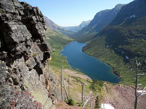 Photo on the route to Lone Walker Mountain.
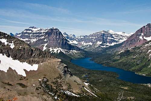 Another saintgrizzly photo, this fellow had a gift. This is a view of the Two Medicine valley from the Scenic Point Trail.
To visit Glacier National Park is to enter a place where Heaven touches Earth affording brief glimpses into the Wonders of Creation.
The "Crown of the Continent" is located in northwestern Montana and shares a border with Waterton International Peace Park in Canada. Driving the world renowned Going-to-the-Sun Road to Logan Pass is a great way to see Glacier.
Typically Logan Pass and Going-to-the-Sun Road opens near the end of June but it can be as early as the middle of June and as late as after July Fourth. If you drive Going-to-the-Sun Highway you still will not reach the fabulous Two Medicine Valley. It is a little out of the way and perhaps as a result receives fewer visitors than other portions of the park.
The Two Medicine Valley which typically opens before The Going-to-the-Sun Highway is located near East Glacier, Montana and is most easily accessed via U.S. Highway 2 which crosses Northern Montana east to west. The Two Medicine Valley is the location of Two Medicine, Dawson, Pitamakan and Cut Bank Passes. It is also home to Sinopah Mountain perhaps one of the park’s most photographed peaks.
The Two Medicine Valley also contains some incredible hiking loops both on trail and off trail. The mostly off-trail Scenic Point Ridge Walk which includes summiting three peaks is located just east of Two Medicine Lake.
The all-trail loop around Two Medicine Lake is a fantastic way to sample the Two Medicine Valley. For a more in-depth exposure consider the strenuous hiking loop from Pitamakan to Dawson Pass that is 18.8 miles (30.26 km) long and crosses 2 of Glacier’s passes in 4 miles (6.44 km). The Hiker's Guide to Glacier National Park rates this loop as strenuous. Two Medicine Trail Map PDF version.
Driving Instructions from East Glacier, Montana:
After reaching East Glacier, Montana on Highway 2 and travel 4 miles (6.44 km) North on State Highway 49 to the Two Medicine turnoff. Drive to the end of the road and park in the Two Medicine Parking lot.
Driving Instructions from St. Mary’s, Montana:
Travel south on Highway 89 to Kiowa Junction, turn right on to Highway 49 and continue 9 miles (14.5 km) to the Two Medicine turnoff. Drive to the end of the road and park in the Two Medicine Parking lot.
Red Tape ... Because We Just Don't Have Enough Rules!
For current National Park Entrance Fees: Current Park InformationFor all the Rules and Regulations governing Glacier National Park look at the Rules and Regulations. It’s always a great idea to read these rules before planning a trip to Glacier National Park. Regulations change from year to year and generally the “I didn’t know about that” excuse does not work as the Federal Government governs the park. Read the rules and regulations and be informed.
You do not have to register for day climbs in Glacier National Park but it is recommended. Registration for this climb can be done at the Two Medicine Ranger Station. Backcountry travel regulations can be found at Backcountry Travel. There is also information from the Park Service on Mountain Climbing in Glacier.
As with all hiking and climbing in Glacier National Park use caution and practice good manners with the wildlife. You are in bear country. Carry your bear deterrent, don’t hike alone and make some noise. For more information please go to the Park's website for Bear Information. The U.S. Forest Service also has helpful information on Grizzly Bear Management.
Special Considerations: The rock in Glacier Park is widely varied and it is not unusual to find several different types of rock on any given route. Know your rocks and be certain of your safety. J. Gordon Edwards has an excellent section in his guidebook on rock and climbing safety. Be safe and know your limitations as well as those who are climbing with you. Also refer to the following links for further details: GNP Rock and Grading System and the GMS Climbing Guidelines.
Suggested Routes ...
![Lone Walker Saddle]() Lone Walker - Helen saddle
Lone Walker - Helen saddle
![Lone Walker Mountain]() Find a way through the cliifs below the saddle.
Find a way through the cliifs below the saddle.
![Lone Walker Mountain]() Another view from the route.
Another view from the route.![Lone Walker Mountain]() A protion of the ridge walk.
A protion of the ridge walk.![Lone Walker Mountain]() A couloir used to access the summit block.
A couloir used to access the summit block.
Climb Glacier National Park has more details on Lone Walker Mountain and suggested routes. It can be ordered at Climb Glacier National Park. Volume Two covers this mountain.
Route Statistics:
One-way Distance: About 7 miles (if the Sinopah is used plan on saving two miles)
Elevation Gained: Just a bit over 3,100 feet
On Trail Direction:
Upper Two Medicine Lake Approach:
Hike to Upper two Medicine Lake from either the North Shore Trailhead or ride the boat and hike from the west end of the lake.
Mount Helen Approach:
Hike to Dawson Pass from either the North Shore Trailhead or ride the boat and hike up the Dawson Pass Trail from the west end of the lake.
Off Trail Direction:
Upper Two Medicine Lake Route:
From the outlet of Upper Two Medicine Lake put on those wading shoes and follow the northern shoreline to the great scree field below the saddle between Mount Helen and Lone Walker Mountain. Don't forget your boots!
Climb up through the scree field to the cliffs below the saddle. Avoid climbing through the cliffs above the lake as they will only require additional time route finding.
There are a number of ways through the cliffs below the saddle. If the best route is chosen most cliffs will be Class III (4) (G.M.S. rating). There are more complicated cliffs available if desired. Bring climbing gear if this is your plan.
From the saddle the rest of the ridge is an enjoyable walk along the summit ridge or on the western side of the ridgeline.
There is just a little more climbing required just below the summit. Route finding is enjoyable through these cliffs. Work up and to the right through the cliffs.
It is also possible to traverse to the west until reaching the southern side of the mountain and slog up more scree to just below the summit.
Be cautious of rockfall while climbing in these cliff areas.
![Lone Walker Mountain Topo]() Lone Walker Topo Map
Lone Walker Topo Map
Mount Helen Route:
According to local climbers it is possible to reach the saddle between Mount Helen and Lone Walker Mountain from Dawson Pass. The page contributor has never used this route. One of my partners has climbed from the saddle to the summit of Mount Helen. He describes it as a series of five false summit before reaching the true summit. He did not describe the route as challenging but he is a very competent climber.
Follow the route description found on the Mount Helen page. After reaching the summit continue by descending to the southeast along the ridgeline. There are numerous false summits and cliff bands to climb down through so be cautious and select a safe route.
After reaching the saddle follow the route as described above in the Upper Two Medicine Lake Route.
Alternate Routes:
It is possible to approach Lone Walker Mountain from either Mount Rockwell or via Aurice Lake from the Two Medicine Pass Trail. Both of these routes would require more time and route finding than the two preceeding routes.
The original page for Lone Walker Mountain was contributed by Dan Shorb. To view the original climber's log for his Lone Walker page please follow this link: original Climber's LogEquipment Recommendations and Camping Information:
![Mount Helen]() The southwest flank of Mount Helen.
The southwest flank of Mount Helen.![Lone Walker Mountain]() A summit view
A summit view
Crucial gear includes: wading shoes if using the Upper Two Medicine Lake route, bear deterrent spray, water, sturdy footwear and a camera. Trekking poles are also helpful in the scree and for traversing along the ridgeline.
There are potential Class IV pitches on this route and inexperienced climbers would do better if belayed through the pitches below the saddle and summit.
There is a park campground at Two Medicine.
Other options for camping include: GNP Campground Information, USFS Campgrounds, Camping on the Blackfeet Reservation or East Glacier Campgrounds.
Backcountry Camping Contributed by Dan Shorb
In order to camp in the backcountry, a $5/person/night permit is required. The permit is a means to manage the backcountry sites to avoid confusing and overcrowding. You can pick up a permit at Apgar and St. Mary Visitor Centers or Many Glacier Ranger Station. Normally between 01 May and 19 Nov, permits can be obtained no more than 24 hours in advance.
$30 reservations for backcountry camping can be made in advance starting 01 May through 31 Oct. These reservations can be made in person at Apgar and St. Mary Visitor Centers or via mail by writing to:
Backcountry Permits
Glacier National Park
PO Box 395
West Glacier, MT 59936-0395
There are designated campsites exist at Upper Two Medicine Lake, Cobalt Lake, and No Name Lake.
Each location includes bear hangs and a cooking area. No fires or stock are allowed, and there is a 1 night limit. Please inquire with the Park as to availability. You must reserve these sites.When to Climb and Weather:
This route would generally be open when the trails of the Two Medicine Valley are open for hiking. Parties traveling too early will more than likely have to deal with snow so plan accordingly.

Lone Walker Mountain Slideshow
External Links:
Glacier National Park in Pictures
Glacier Mountaineering Society
Two Medicine Trails
Visit Montana
 Lone Walker - Helen saddle
 Find a way through the cliifs below the saddle.
 Another view from the route.
 A protion of the ridge walk.
 A couloir used to access the summit block.
 Lone Walker Topo Map
 The southwest flank of Mount Helen.
 A summit view
Other options for camping include: GNP Campground Information, USFS Campgrounds, Camping on the Blackfeet Reservation or East Glacier Campgrounds.
Backcountry Camping Contributed by Dan Shorb
In order to camp in the backcountry, a $5/person/night permit is required. The permit is a means to manage the backcountry sites to avoid confusing and overcrowding. You can pick up a permit at Apgar and St. Mary Visitor Centers or Many Glacier Ranger Station. Normally between 01 May and 19 Nov, permits can be obtained no more than 24 hours in advance.
$30 reservations for backcountry camping can be made in advance starting 01 May through 31 Oct. These reservations can be made in person at Apgar and St. Mary Visitor Centers or via mail by writing to:
Backcountry Permits
Glacier National Park
PO Box 395
West Glacier, MT 59936-0395
There are designated campsites exist at Upper Two Medicine Lake, Cobalt Lake, and No Name Lake.
Each location includes bear hangs and a cooking area. No fires or stock are allowed, and there is a 1 night limit. Please inquire with the Park as to availability. You must reserve these sites.
When to Climb and Weather:
This route would generally be open when the trails of the Two Medicine Valley are open for hiking. Parties traveling too early will more than likely have to deal with snow so plan accordingly.Lone Walker Mountain Slideshow
External Links:
Glacier National Park in PicturesGlacier Mountaineering Society
Two Medicine Trails
Visit Montana