
-
 12031 Hits
-
 90.18% Score
-
 32 Votes
|
|
Mountain/Rock |
|---|---|
|
|
48.56766°N / 113.36865°W |
|
|
Glacier |
|
|
Hiking, Mountaineering |
|
|
Summer, Fall |
|
|
8341 ft / 2542 m |
|
|
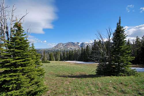
Where the Mountains Meet the Prairies...
Part of the allure of climbing on Glacier's rugged, windswept eastern front is to tread where the mountains meet the prairies. Here the jagged, glacially-scoured landscape abruptly transitions to the rolling hills and endless fields of grass that define the Great Plains. Summit views to the east are mesmerizing in both their vastness and sparseness. On clear days, the Sweet Grass Hills, an island range that curiously rises over 3,000 feet above the surrounding flatland, are visible on the horizon. Tree line is rather low, so there are often spectacular views at relatively low elevations. Wildlife abounds, with bear, bighorn sheep, and mountain goats gracing the barren slopes.The Blackfeet community of Browning is also visible from these peaks. It is hard to ignore the Native American presence on Glacier's east side. Eagle Plume, Little Dog, Red Crow, Kupunkamint, and White Calf are just a few of the many place names with obvious native roots. The eastern front marks an entryway to what the Blackfeet call "The Backbone of the World". This has been a special place for quite some time, and to hike and climb in the area one must possess a fair amount of both fortitude and humility.
What's In A Name?
The wolf is a very important figure in Blackfeet culture. Before horses had been introduced, the Blackfeet performed as wolves both at camp and while stalking vast bison herds. "By becoming brothers to the wolf, Blackfoot could quickly discover effective means of manipulating bison" (1). According to Jack Holterman's Place Names of Glacier National Park, Mad Wolf was the name of a famed Blackfoot warrior whose recovery of a sacred albino bow case from a rival tribe immortalized him in tribal lore (2). The Blackfeet word saiyi (english: mad wolf) describes a crazy or rabid wolf or other animal. The traditional name was also used, albeit with a spelling variation, to name Mount Siyeh (the fifth tallest peak in the entire park).See "References" section at bottom of page for additional reading.
Mad Wolf Mountain as viewed from the north
Getting There

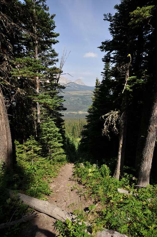
View of Mad Wolf Mountain from the Cut Bank Ranger Station. The first hour + of the climb will be spent in the lush forest below Cut Bank Ridge.
Mad Wolf Mountain can also be accessed via a network of gravel Blackfoot reservation roads that climb to the top of Cut Bank Ridge. A Blackfoot Recreation Permit is required (available at local businesses and in nearby Browning) for parking and hiking on reservation land. Please inquire locally if you wish to attempt this approach, as I have not driven any of these roads.
Route Information
North Ridge RouteBushwhack Option
From Cut Bank Campground, look directly south and take note of the north summit of Mad Wolf Mountain. The easiest routes to the actual summit exist to the southeast of this high point. From the campground (near sites 6, 7, and 8) a series of well-worn trails lead steeply downhill to Cut Bank Creek. Ford the creek, and continue south. At least two more small tributaries need be forded within the first 15 minutes or so of hiking. A small meadow or two may be encountered, but eventually a thick, old-growth forest is entered and the bushwhacking fun begins! There really is no best route here; try to follow sparse game trails and plod uphill. The goal here is to simply gain elevation and continue bearing south. About an hour or so after leaving the campground, a network of incredibly well-worn game trails is encountered. It is my understanding that the condition of these trails can be attributed to a number of feral horses and elk that frequent the area. Continuing uphill, the forest gives way to open meadows, and the bushwhacking thankfully comes to an end. Utilize the increasingly open views for reorientation, and gain the crest of Cut Bank Ridge. Enjoy the spectacular vista to the west!!!
Boundary Clear Cut Option
Boundary Clear Cut
A clearcut runs along most of the eastern edge of Glacier, marking the boundary with adjacent Blackfeet tribal lands. As of August 2014, it was possible to follow this clearcut all the way to Cut Bank Ridge. From the Cut Bank entrance gate, head downhill and cross a rivulet of Cut Bank Creek before encountering the creek proper. For the creek. Once on the south bank, locate and follow an unmaintained trail along the boundary clearcut all the way to the top of Cut Bank Ridge. A few loose, steep slopes, ample downfall and some very thick patches of brush will be encountered, but it is comparatively much less of a hassle than the bushwhack from the campground. This route is definitely longer than the bushwhack option and involves a bit more elevation gain. Once the top of Cut Bank ridge is reached, simply follow it to the west, losing elevation in the process. Find the most practical place to circumvent a large drainage before heading directly towards Mad Wolf Mountain.
Old Boundary Trail Option
Per Summitpost member awhite28, an old section of the Boundary Trail can also be used to limit bushwhacking. This trail is unmaintained, but curiously is still labeled on National Geographic topo. The Boundary Trail once served as a major passageway by linking the train station at East Glacier Park to the eastern front of the park. Someone has cleared it in recent years, and it can be used to gain access to Mad Wolf Mountain. Hike 1/2 mile west on the Triple Divide Pass Trail from Cut Bank Campground. An old trail branches downhill to the left to Cut Bank Creek. Ford the creek, pick up the trail on the opposite bank, and follow up to Cut Bank Ridge.
 |  |
|---|
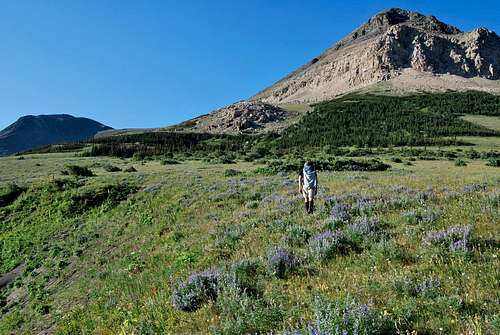
After cresting Cut Bank Ridge, look southward to the broken slopes of Mad Wolf Mountain. The folded and crumbly white cliff band of Altyn limestone that wraps across the mountain poses a major obstacle. Fortunately, safe routes through the cliffs exist with careful route finding. Take note of a prominent boulder field that litters the eastern flanks of the north summit high above a patch of low-lying conifers. The goal here is to climb towards the boulder field by detouring up and around the trees. There, the massive basin encompassing the north face of Mad Wolf comes into view.
Ascending toward the obvious boulder field
Directly above the boulder field, a prominent scree field leads uphill through a safe break in the otherwise impassable cliffs. Slog up the scree field until the terrain steepens, then climb one at a time up a loose class III section before topping out on a wide, grassy break in the limestone. The crux of the route involves identifying an obvious game trail that leads to the south. Follow the trail across a loose ledge for a couple hundred feet, and after passing around a rocky shoulder, the mountainside opens up and the going becomes very straightforward. The terrain above the Altyn limestone is almost universally class II, and one can simply make an ascending traverse across loose scree and talus towards the north summit ridge.
 |  |  |  |
|---|
One the ridge is gained, the footing substantially improves, and its an easy walk to the broad summit block. In my experience, no matter which approach is utilized, the North Ridge Approach is far and away the fastest and easiest route to the summit.
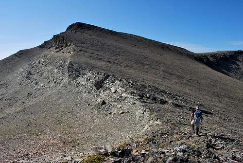
Solid footing is encountered on the north ridge.
North Basin Route
Hike off-trail to the top of Cut Bank Ridge as described above. Instead of heading towards the north summit of Mad Wolf, continue on horse trails through boulder-strewn meadows towards the true summit. Tall, crumbly cliffs of Altyn limestone wrap around the rim of the entire basin. Aim for the southernmost point of the basin. From here, at least two routes exist through and around these towering cliffs:
1) Head east on well-worn game trails, bypassing underneath the Altyn limestone. After gaining some elevation, look right (south) for an easy grassy break that leads safely around any dangerous cliffs.
2) For a class III option, hike straight to the head of the great north basin. Utilize game trails to identify the best class III route (cairns may mark the way) directly through the Altyn limestone. The rock is quite solid (and very sharp - gloves may come in handy) here, and keen eyes should be able to identify paths that animals and humans alike have previously used to negotiate the cliffs. Make sure to mark your route with cairns if you plan to return in this direction; otherwise, you may waste time hiking along the top of the cliff band searching for the safest way down. Once the cliff top is gained, it is a very tiring, yet straightforward class II slog towards the summit block. As the summit block is neared, gain the ridge the stretches out to the east. From there, a short, obvious class III gully leads to the summit.
 |  |
|---|
Mad Wolf Circuit
From the summit of Mad Wolf, it is hard to ignore the amazingly broad, open ridge that leads westward towards Eagle Plume Mountain. For those willing to undertake a 10+ hour route, it is possible to follow the ridge from Mad Wolf all the way to the top of Eagle Plume, then to continue northward to Bad Marriage Mountain. Gordon Edwards refers to this route as "The Mad Wolf Circuit", and it affords the hardy mountaineer with solitude and unbelievable views on the high ridges that link the three peaks. Be forewarned that many groups find great difficulty in descending from Bad Marriage Mountain. I am aware of several parties who have taken anywhere from 13 to 18 hours to complete this route! After descending into the wild valley encircled by all three mountains, it is very challenging to identify the safest way down around a great waterfall that drains the basin. The only route exists just southeast of the falls and is quite difficult to locate due to extensive cliffs, krumholzt, and brush. I recommend attempting this circuit route with someone who has experience successfully descending in this direction.
I know of at least one account of a group descended the west flanks of Bad Marriage towards the Cut Bank Pass Trail. Apart from some bushwhacking and a ford of the North Fork of Cut Bank Creek, they described much less difficulties than other parties who descend Bad Marriage to the east. I personally have not attempted this route.
 |  |
|---|
Summit Views
Views from the eastern border of Glacier National Park are always spellbinding, and Mad Wolf is no exception. To the east, the Great Plains stretch out for what seems like forever, and on clear days the Sweet Grass Hill are visible on the horizon. Views to the southwest are particularly appealing; serene and remote Lonely Lakes and Running Crane Lake perch in the shadow of impressively huge Red Mountain. Mount Stimson towers in the far distance behind Eagle Plume Mountain, and views to the north include the mighty tops of Going-to-the-Sun Mountain and Mount Siyeh.When To Climb
Due to extreme winters along the Continental Divide, problematic snow can linger on trails and mountain slopes well into July and August. Hence, the prime climbing season in Glacier is rather short, often beginning in June and lasting into late September/early October. However, some lower peaks and south facing slopes can be safely attempted much earlier in the season. Your best best is to inquire locally about snowpack and weather conditions. Personally, I have found the NOAA website to be the most reliable resource for detailed weather forecasts and snowpack information for the greater Glacier area.Mad Wolf can likely be climbed from the north as early as June. The only factor that may complicate either of the northern approaches would be lingering snow in and around the Altyn limestone at the 6,800 - 7,000 foot mark. The class II terrain above this cliff has so many safe routes that any snow could be easily detoured around. There are great views of Mad Wolf from a pullout on Highway 89 a few miles north of the turnoff to Cut Bank Campground. This is probably the best place to assess the terrain prior to any ascent.
Where To Stay

View of Mad Wolf from Cut Bank Campground
Other places to stay in the general area:
Two Medicine Campground - 100+ sites, beautiful setting, approximately 20 mile drive from Cut Bank Campground.
St. Mary - The small, bustling tourist village at the east entrance of Going-to-the-Sun Road has multiple lodging options. Approximately a 25 mile drive to Cut Bank Campground.
Browning - Multiple lodging options exist in the Blackfoot Reservation town of Browning. Approximately 17 miles from Cut Bank Campground.
Red Tape, Safety, Wildlife, etc.
Entrance Fees
A fee is required for all persons entering Glacier National Park. As of November 2016, single vehicle rates are $30 for a seven day pass, or $45 for an annual park pass (increasing to $50 in January 2017). A lower fee is charged for hikers and bikers; please visit the NPS fees webpage for a full explanation of the entrance fees.
Seasonal Closures
Glacier is subject to extreme winter weather conditions, and as such, much of the park is virtually inaccessible for the majority of the year. The Going-to-the-Sun Road is typically open in its entirety from mid-June to mid-September, and many of the developed areas of the park (including the historic lodges and most of the campgrounds) operate for a short window as well. Information on the operational status of front country campgrounds and park roads can be found by clicking on the hyperlinks.
Glacier Rock Grading
Due to the sedimentary nature of the rock in Glacier National Park, unique rock grading systems have been established by both Gordon Edwards and the Glacier Mountaineering Society. Please refer to the Glacier National Park Rock & Grading Systems Summitpost page (authored by Fred Spicker and Saintgrizzly) or the website of the Glacier Mountaineering Society for detailed information. If you are new to climbing in Glacier, I highly recommend checking out this info before attempting any climbs in the park. Oh, and don't forget to wear your climbing helmet!
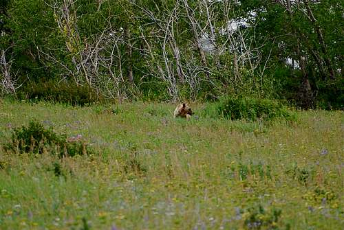
![grizzly bear off Many Glacier Road]()
Hey bear!!!Wildlife
A Climber's Guide to Glacier National Park
Pick up a copy of Gordon Edwards' classic A Climber's Guide to Glacier National Park. It's an absolute must for anyone who wants to safely venture to one of the park's many accessible mountain summits. Edwards spent many years as a seasonal ranger in Glacier, where he developed a deep passion for exploring the park's mountains and sharing its splendors with others. The book provides a fantastic history of climbing in Glacier, and his detailed and colorful route descriptions are a fantastic introduction to off-trail hiking and climbing in the park.
Hey bear!!!
The park is home to lots of potentially dangerous wildlife, including moose, black bear, grizzly bear, and mountain lion. Hike loud, carry bear deterrent spray (and know how to use it!), check local trail postings (for area warnings/closures) and let someone know your intinerary before heading out into the park. Also, note that special precautions are in place in all front and back country campgrounds to limit human-bear encounters. Regulations are posted everywhere (picnic tables, ranger stations, bathrooms) and it is every visitor's responsibility to take them seriously. Remember, a FED BEAR IS A DEAD BEAR! Please visit the NPS camping webpage for more detailed information.
External Links
Visit the FANTASTIC Glacier National Park page, a labor of love by late Summitpost member Saintgrizzly (R.I.P.), or the NPS webpage for more detailed information on "The Crown of the Continent".
2. Holterman, J. (2006). Place Names of Glacier National Park (3rd Edition). Helena, MT: Riverbend Publishing.
References
1. Barsh, R.L. & Marlor, C. (2003). Driving Bison and Blackfoot Science. Human Ecology, Cornell University, 31 (4). Retrieved from http://www.biomedsearch.com/article/Driving-bison-Blackfoot-science/112318510.html.2. Holterman, J. (2006). Place Names of Glacier National Park (3rd Edition). Helena, MT: Riverbend Publishing.