-
 47854 Hits
-
 87.44% Score
-
 27 Votes
|
|
Mountain/Rock |
|---|---|
|
|
48.51388°N / 113.60413°W |
|
|
Mountaineering |
|
|
Summer |
|
|
10142 ft / 3091 m |
|
|
Overview
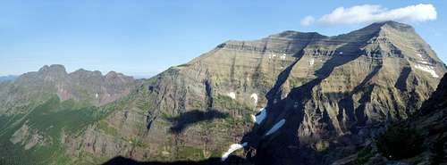
This massive mountain rises some 6,000 feet above the surrounding terrain deep in Glacier's remote Nyack country. At 10,142 feet it is the second tallest peak in the park and is named after Henry L. Stimson, the United States Secretary of War during World War 2.
Although the peak looks flat topped from some directions, the summit is actually a long ridge which is only about 2 yards wide in most places. Every thing else about this peak is epically large. Its northwest face rises 6,300 feet above Nyack Creek in a single stroke, making it one of the tallest faces in the country. Nyack Creek separates Stimson and its sister peak Mount Pinchot from the continental divide to the east. The two peaks are connected by a low saddle.
Stimson can be climbed from this saddle, which provides access to the Southeast ridge, a class 3 climb. The peak can also be climbed via the west face, which is a class 3-4 climb.
Getting There
Because Stimson is situated in one of the most remote corners of Glacier National Park getting to the base is a struggle no matter which direction you come from. The Nyack valley is classified as a primitive backcountry area by the park service, which means the trails in this region are poorly maintained (I counted 148 downed trees between Cut Bank Pass and Beaver Woman Lake). Saintgrizzly informed me that most of these trees were from a major storm in November of 2006 and that the park service is working on clearing them. As of July 2007 however the trail was still filled with them so I would call the park service before planning a trip.
The southeast ridge route begins at Beaver Woman Lake, which is 24.8 miles up the Nyack Creek trail. The trail begins near Walton Ranger Station along Highway 2. A ford of the middle fork of the Flathead River is required to gain access to the trail, and this can be extremely dangerous early in the season. The area is thickly forested so don't expect much for views on this death march. A more scenic and slightly shorter route is to start at Two Medicine Lake on the east side of the park. The downside of this route is it requires climbing 3,000 feet up and over the continental divide, but on the other hand, you'll see some of the most amazing and remote scenery in the park as the trail follows the divide for 5 miles between Dawson and Cutbank pass.
The west ridge route requires 12-mile hike from the up Nyack Valley.
Red Tape
This area is a primitive backcountry area, which means it has slightly less red tape than other areas in Glacier. You still need a backcountry permit, but you are not limited to designated campsites and you won't have much competition in securing a permit, even in peak season. More information can be found at Glacier's website.
Camping
Although camping is not limited to designated sites the park service maintains several in the area and they usually make for better camping than trying to cut your own out of the brush. The campground at Beaver Woman Lake is beautiful (although decimated by a recent avalanche) and makes a great base camp for those attempting the southeast ridge.


Fred Spicker - Oct 22, 2007 8:22 am - Voted 10/10
Route NamesYou state: "The peak can also be climbed via the west ridge, which is a class 3-4 climb." Edwards names this route the West Face Route - and in reading the description, this is a far better name than west ridge as the route does ascend mainly on the face. See my addition on the route page regarding the Southeast Spur Route.