-
 12475 Hits
-
 86.85% Score
-
 23 Votes
|
|
Mountain/Rock |
|---|---|
|
|
44.06110°N / 115.0481°W |
|
|
Boise |
|
|
Hiking, Mountaineering, Trad Climbing, Scrambling |
|
|
Summer, Fall |
|
|
10081 ft / 3073 m |
|
|
Overview
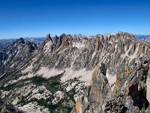
Location: Central Sawtooths, just south of the Monte Verita Ridge. Peak is just on the west side of the main Sawtooth Crest near the Upper Goat Creek drainage. Typical access is difficult from any direction and requires off trail scrambling.
Nearby Peaks: Packrat Peak, La Fiamma, Warbonnet Peak, Monte Verita Peak, Mt. Underhill
Linkups: Mt. Underhill, Packrat Peak
Difficulty: Class 4 scramble route / Class 5 rock routes
Usage: Scrambling, Rock Climbing
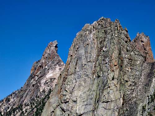
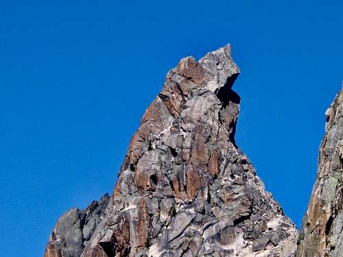
Terrain: Typical jagged Sawtooth ridge- steep talus slopes below with smooth granite summit blocks. Rock is relatively solid. Lakes below.
Traffic: Extremely light traffic. Perhaps one ascent per year on average because of how rugged the approach is and the neighboring Packrat and Warbonnet. Still, rap anchors were found.
Summit Register: Yes, placed.
History / Entomology: Originally called Japan Peak, Mayan Temple if viewed from the Warbonnet area, appears to be a large temple. The jagged peaks in this area are considered by some to comprise the most spectacular in the range and perhaps the state of Idaho. Adding to the mystery and allure is the rugged 10-12 mile hike and scramble to get even close and the fact that these peaks are hidden from scenic viewing along roads.

Getting There
Nearest Paved Roads: ID-21, ID-75
Nearest Dirt Roads / Conditions: Grandjean Road (good), RedFish Lake Road (paved)
Approach Trails / Conditions: Baron Creek Trail (decent- upper parts have improved near Baron Lakes)

Routes
Goat Creek Route: This approach is not recommended as you must navigate the trail-less Goat Creek drainage for 6 difficult miles. However, this route offers scenery seldom seen. From the Grandjean TH, follow the South Fork Payette River south, crossing Baron Creek (difficult in high water). Just south of Grandjean Peak at about 2.8 miles in, leave the trail and head SE up the Goat Creek drainage. The drainage gains very little elevation at first as you must navigate over downfall, thicket, steep slopes. Near Goat Falls, the slopes steepen. Stay on the north side then cross south once atop the Falls. Follow the creek as the terrain opens slightly until you are just NW of Blue Rock Lake (difficult to tell). Ascend very steep slopes to Blue Rock Lake. Ledgey Class 3 access is possible if carefully navigated. From Blue Rock Lake enjoy views of Blue Rock Dome and La Fiamma. Hike around the lake and up into giant boulders until Lake 9352 is reached.
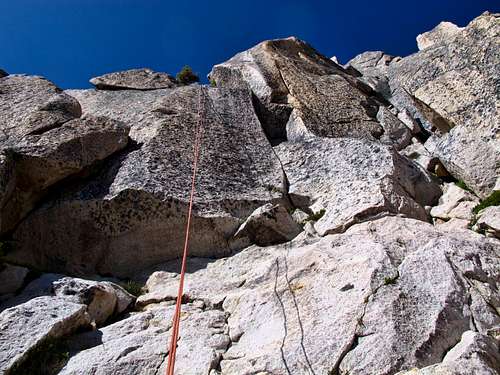
From Lake 9352, scramble toward the saddle of Packrat and Mayan Temple staying just south to avoid towers. At the south base of Mayan Temple, find the weakness in the rock and the only apparent scramble route. The scramble route is about 150 feet of Class 3 and Class 4 moves and goes up the SSE face. One of the more challenging moves involves stepping out onto a ledge, then jumping into a chimney with exposure below and clinging on below a small overhang of separate blocks. The summit has fantastic views of the surrounding peaks, and impressive sub towers along the north ridge.
Descent: Down climb about 50 feet into a scramble gully that cliffs out. At the end of this is the rap station with 1 bolt plus some interesting backup. One 60m rope rappel will get you to the scramble area. Instead of torturing yourself via the Goat Creek drainage, find the slope just south of the Mayan temple and carefully scramble north to Warbonnet Lakes. From the Lakes climb up and over a spot just west of Point 9769 and down to Baron Lakes. You will see the Warbonnet climber's trail in this area. From Baron Lakes follow the trail back to Grandjean.
Main Route Stats: 23.7 miles / 9009 (round trip)
Average RT Time: 10-14 hours
Baron Lakes Route: See Above for more Details. Reverse the Descent on the Above route, accessing Warbonnet Lakes from either Baron Lakes or Baron Pass (Redfish Lake side). Times are highly variable and many will do this as an overnighter.
Climbing Routes: Glorious climbing on solid granite- Northwest Ridge (5.8), Northeast Ridge (5.9), and West Face (5.10) -per Lopez

Red Tape
Jurisdiction: National Forest (Sawtooth National Recreation Area)
Permit: No
Other Users / Issues: Pack Animals
Maps: USGS Quad- Warbonnet Peak
Guide Book: Tom Lopez, Idaho: A Climbing Guide,
When To Climb
Climbing Season: Summer, Fall (Jul-Sep)- variable, some years snow will linger well into August and hinder or help travel.
Ideal Climbing Time: August & September
Nearest Weather Station: Stanley
Weather Relative to Region: deep in the heart of the most jagged peaks in the Sawtooth Range, this area receives a typical amount of snow and cold. Nearby Stanley often has the coldest temperatures in the lower 48.

Camping
Car Camping Sites: Grandjean Campground has great sites, as does Redfish Lake
Backpacking Sites: Many spectacular options if you can get your pack in. Warbonnet, Bead Lakes, and Baron Lakes have the most "knock your socks off" scenery.

Flora & Fauna
Potential Wildlife: Badger, Beaver, Black Bear, Mule Deer, Pronghorn, Cougar, Coyote, Elk, Marmot, Marten, Moose, Mountain Goat, Pika,
Confirmed Wildlife: Pika, Mountain Goat, Marmot
Vegetation: Stinging Nettles, Willow, Berry Brush, Pine (little vegetation above 9000 ft)