
|
|
Mountain/Rock |
|---|---|
|
|
37.88027°N / 107.68976°W |
|
|
Mountaineering |
|
|
Summer |
|
|
12804 ft / 3903 m |
|
|
Overview
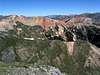
 West face, McMillan is the closer grassy peak
If you like alpine tundra, you will love McMillan Peak, a fuzzy green mountain covered with vast fields of wild flowers.
McMillan Peak, along with Red Mountain #3 (12890 ft) to the north, Ohio Peak (12673 ft) and Anvil Mountain (12537 ft) to the south, form a chain of 12ers that runs north-south on the east side of Route 550 between the town of Silverton and the Red Mountain Pass in the San Juan Mountains of southwest Colorado. Except for McMillan Peak, the rest of these mountains have red scree slopes above the treeline. When viewed from the nearby mountains, McMillan appears as an inviting oasis that interrupts the continuity of the barren screelands.
The western slopes of McMillan are grassy and gentle. These slopes can be reached via a four wheel drive road that starts at the Red Mountain Pass on Route 550 and and heads south over the slopes of McMillan and Ohio Peaks before returning to Route 550 a few miles south of the Red Mountain Pass. There seems to be some private property to the northwest of McMillan Peak so you may want to avoid this area altogether. To the southwest, Big Horn Gulch (and US Basin above it) can provide good access. The hike starts at the treeline (11520 ft). There is no trail but you can easily go up the beautiful grassy slopes that continue all the way to the summit. As you go higher, you will get better views of the long chain of 13ers that rise to the west of Route 550.
The summit of McMillan Peak consists of two small hills that have roughly the same elevation. The east hill is a few feet higher and and is the official summit. Only the west summit is visible from a short segment of Route 550 south of the Red Mountain Pass. The east summit is recognizeable by the giant communications tower that has been erected on top of it. This tower can be seen from the town of Silverton 5 miles to the south.
Unlike its gentle western slopes, the eastern slopes of McMillan drop steeply into the valley of Cement Creek. While from Route 550, the terrain appears as "rolling hills", from the east, McMillan appears as a prominent mountain that dominates the view.
McMillan Peak is rarely climbed. In good weather, you can have a great day all alone on top this beautiful mountain. You will find yourself completely surrounded by 13ers in every direction.
For a discussion of private property issues in this area look under "Additions & Corrections" for what Aaron Johnson has added.
 |  |  |  |  |
Getting There
 NE face of McMillan
From Silverton, drive 12 miles north (or 11 miles south from Ouray) on Route 550 to the Red Mountain Pass (11018 ft). A few hundred feet south of the pass, you will find a four wheel drive road on the east side of the highway (this road will require 4WD but it is easy to drive). Turn onto this road and then make an almost immediate right turn. Follow the road through a Pine forest until you see a gated private road on the left (that goes to the summit of Red Mountain #3).
Continue on the main road and cross the first and then the second creek. At 1.3 miles from Route 550, you will reach the third creek in an area just above the treeline (11520 ft). This is the Big Horn Gulch and will serve as your trailhead.
 |  |  |  |  |
Backcountry Skiing
McMillan Peak area is a wonderful place for backcountry skiing. See this album by Liba Kopeckova. You can also check out this site:http://www.theskiingexperts.com/best-colorado-backcountry-ski-areas/
 Saint Paul Lodge
Red Tape
No fees or permits needed for day hikes. For road conditions call San Juan National Forest, Durango, CO (970)247-4874. |  |  |  |  |
When To Climb
Easiest in summer. |  |  |
Aaron Johnson - Aug 18, 2003 7:23 pm - Voted 10/10
Untitled CommentNader's advice to stay off the private property should be heeded carefully. The guy's name presently escapes me, but over the years he has bought up mining claims northwest of McMillan Peak that include much of the Red Mountains and Ironton Valley on the east side of Route 550.
In recent years, a heated debate has been going on because the guy wants to sell and develop this land for large lot single dwelling homes. This of course has raised the ire of the City of Ouray, a number of historical societies and a host of other groups. Attempts to buy the land have been refused because the guy is asking for massive and ridiculous amounts of money.
Ouray has tried some legal stuff to stop the guy from doing his development plans, and I believe the Forest Service has gotten involved, much to its dismay. As a property owner, the guy is within his rights and that has been his argument. In light of the historical significance of the area, including the ghost towns of Red Mountain and Ironton, special circumstances may warrant a different treatment of this property rights issue. This remains to be seen, as it will be tied up in the courts for ages.
The guy, being a property owner, is justifiably inscenced by this. His rights have ben trampled on. But he doesn't seem (last I knew) to be open to reason and hearing others out over the issue either. So he's been a real pain in the ass, and to some extent, justifiably so. Hopefully an arrangement that satisfies everyone will be agreed upon.
HOWEVER-It would be a shame to see the area developed with multimillion dollar homes. That would be just pathetic. What the mountain lovers have going for them is this: Who in their right mind would want to live in this area in the winter? This place is just downright perilous and one of the most avalanche prone areas in the state. You could be stranded there for days or weeks, depending on how far back in the sticks your private road extends. This argument has been presented to dissuade the land owner from developing.
Another argument is environmental. Just running roads and infrastructure into the area would be a blight beyond belief, not to mention the massive expense (but when you're mega rich, all of this just doesn't matter any more than lint in your pocket).
As maintainer of this page, nader may have opened up an interesting can of worms that will make for informative and entertaining reading, if he can ever find and keep track of these events. Unfortunately, this could mean lots of work as a maintainer, similar to the Culebra Peak page which jgsman submitted and is currently burdened with. If nader really plans and wants to do a good job, keeping track of the "real time" elements concerning these legal issues involving this and a number of his other mountains, will be a chore.
Have fun, nader!