
-
 17328 Hits
-
 74.92% Score
-
 5 Votes
|
|
Trailhead |
|---|---|
|
|
Los Angeles |
|
|
Spring, Summer, Fall, Winter |
|
|
3560 ft / 1085 m |
Overview: Entree to a Peak Quartet
This trailhead (3,560’ elev.) features a developed campground for car campers and access to a popular loop hike of 4 peaks in this part of the San Gabriel front range. This quartet of peaks includes Rabbit Peak (5,307’), Granite Mountain #1 (6,600’), Round Top Mountain (6,316’) and Iron Mountain #3 (5,040’) along ridge and fire road. One can also reach Mill Creek Summit to the north by following County Fire Road 4N18. Granite Mountain #1 (6,600')
 Rabbit Peak (5,307')
Usually, the peak quartet loop is done clockwise, starting with Rabbit Peak and ending with Iron Mtn. #3. For this, start on County Fire Road 2N23 at the north end of the campground and leave the fire road about a mile later to get onto the ridge which ascends to Rabbit.
 Another view along County Roadk 2N23, 9.15.07
 Along Fire Road 2N23, 9.15.07
Alternatively, one could hike the 4 peaks in a counter-clockwise direction from the campground by hiking up the west ridge of Iron Mtn. #3 on fire break to its summit and then on to the other three.
 Iron Mtn. #3 (5,040')
 Round Top Mountain (6,316')
The campsites at the Monte Cristo Campground have picnic tables and fire rings. There are outhouses available. Campsites are $12 per night.
Driving Directions
From the 210 Freeway, exit at Angeles Crest Highway (SR 2) and go north for 9.5 miles to Angeles Forest Highway. Turn left onto Angeles Forest Highway and drive 10 miles to the entrance to the campground on the right. Turn right into the campground.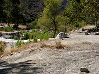 Monte Cristo Campground, 9.15.07
Red Tape
You will need an Adventure Pass or Golden Eagle Pass to park in the Monte Cristo Campground day use lot. These passes can be purchased ($5 per day or $30 for a yearly pass) at the Clear Creek Information Station, which station is located where the SR2 and the Angeles Forest Highway intersect. Otherwise, the passes can be purchased at major southern California sporting goods outlets.Alternatively, if you pay for a campsite, the Adventure Pass will not be necessary.
When to Visit
This trailhead can be accessed virtually year-round. During the winter, depending on the snow level, you may need snow tires or chains for your vehicle. When chains are required, note that the CHP sets up road-blocks, usually along SR2, to ensure either that chains are put on or the vehicle is equipped with snow tires.Check forecast information in local newspapers or internet weather services during the winter months. Check with the California Department of Transportation (CALTRANS) (see link below) on road conditions and closures during the winter.
Other Information
USGS Topos Chilao Flat 7.5Tom Harrison Angeles Front Country Trail Map (1:63,360 scale)
San Gabriel Mtns. Recreation Topo Map (1:62,500 scale), Western Section
(Angeles National Forest and the Verdugo Mountains) by Fine Edge Productions
External Links
California Dept. of TransportationAngeles National Forest
Adventure Pass information