
-
 37449 Hits
-
 79.04% Score
-
 10 Votes
Overview: Avenue to Switzer Falls, Bear Canyon, Lower Arroyo Seco and Red Box Gap
Switzer’s Picnic Area is both a popular day-use area for those wanting picnic facilities in a sylvan setting and those desiring a trailhead with multiple entry points into some beautiful areas of the San Gabriel front range.

The creek at the trailhead
Different sections of the lengthy Gabrielino Trail begin at either end of the main trailhead parking area situated about 0.6 miles below Angeles Crest Highway. The section of the Gabrielino Trail beginning at the west end of the parking area, after crossing the bridge over the creek, takes you first above Switzer Falls (you can detour to visit the Falls).
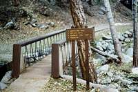
Beginning of trail to Falls and Bear Canyon
In 1 ½ miles, you come to a junction where the Gabrielino Trail turns west and drops into the lower Arroyo Seco. The trail on your left at this junction is the Bear Canyon Trail proceeding southeast into beautiful Bear Canyon, the largest tributary of the Arroyo Seco. In 2.2 miles, the Bear Canyon Trail arrives at Bear Canyon Campground. From there, 1.8 miles more will get you to Tom Sloan Saddle, itself a major trailhead junction in the front range.
The section of the Gabrielino Trail at the other (east) end of the trailhead parking area ascends for about 4 ½ miles topping out at Red Box, another major trailhead in its own right. Along the first mile of this part of the Gabrielino Trail are numerous interpretive nature signs that provide you with a lot of information about the terrain and flora in this part of the mountain range.
A third trail worthy of mention is the Nature’s Canteen Trail. It connects with the upper end of the paved road leading down into the main trailhead parking area. This trail traverses west on the slope below the Angeles Crest Highway 0.6 miles to the Clear Creek Information Station.

End of Nature's Canteen Trail from Switzer's to Clear Creek

Beginning of Nature's Canteen Trail from Switzer's
Driving Directions
From the 210 Freeway, exit at Angeles Crest Hwy (SR 2) and go north. At 9.5 miles, you will come to the Clear Creek Information Station and the junction with Angeles Forest Highway. Continue straight on SR 2 about ¼ mile and you will see the Switzer’s Picnic Area sign and a large entrance gate on your right. Turn right and drive go past the gate for about 0.6 miles to the large paved parking area next to the creek.
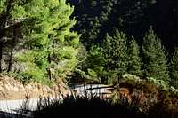
Along the road dropping into the trailhead area
If (1) you arrive before 8 a.m., (2) the gate is otherwise locked, or (3) the parking lot at the main trailhead area is full, you can park in the large paved area adjacent to the entry gate. Then simply hike down the paved road to the main trailhead area.
Red Tape
You will need an Adventure Pass to park your vehicle anywhere within the Angeles National Forest, including this trailhead. These passes are currently sold at the Clear Creek Information Station, which you passed on SR2 about 1/4 mile back. The passes are $5 per day or $30 for a yearly pass. Adventure Passes are also sold at most sporting good stores in southern California
No permits are required for hiking any of the trails accessible from this trailhead.
When to Visit
The trailhead is, for the most part, accessible year-round. However, during winter months when it snows, you may need tire chains or snow tires for your vehicle to get to this trailhead.
Other Information
USGS Topos Condor Peak 7.5
Note that the picnic area where the trails start at either end of the parking area receive very heavy use during the summer months.