
-
 39069 Hits
-
 76.66% Score
-
 7 Votes
|
|
Trailhead |
|---|---|
|
|
Los Angeles |
|
|
Spring, Summer, Fall, Winter |
|
|
4640 ft / 1414 m |
Overview: A Major Hub
Red Box is a major hub for those launching hikes and bike outings in the front range of the San Gabriel Mountains. The prominent eye-catching gap in the mountains where this trailhead is located is visible from miles away.
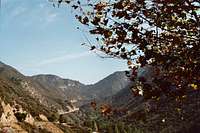
View from Clear Creek Junction to Red Box Gap
The Red Box Ranger Station is located at this trailhead. You will also find portable toilets, picnic tables and water available. The Haramokngna American Indian Cultural Center is situated here in the event you're interested in learning a little about the native tribes that lived in the San Gabriel Mountains.
There are three principal entry points into the front range from this trailhead and two of those entry points involve descents.
The long-stretching Gabrielino Trail (it roughly forms a semi-circle around the central part of the front range) passes through Red Box.
 Destinations from Red Box Trailhead
If you take this trail west from Red Box, you will drop 4.5 miles to Switzers Picnic area which in turn gives you access to beautiful Bear Canyon and to the lower Arroyo Seco.

Descent to Switzers 4.5 miles

Looking from Red Box Trailhead to Clear Creek
Take the Gabrielino Trail east from Red Box and you will descend about 2.4 miles to Valley Forge Campground.
 Descent to Valley Forge Campground and beyond
Further east the trail intersects the daunting sounding Rattlesnake Trail (which goes south) and the Silver Moccasin Trail (going north). Of course, there is lots more beyond this on the Gabrielino Trail. Note that the Red Box Rincon Fire Road roughly parallels the Gabrielino Trail all the way from Red Box to Newcomb Pass, but the road is closed to the public.
The third main entry point goes north from the trailhead. Cross the Angeles Crest Highway and go northeast along the highway for about 100 feet. Then take the Barley Flats Fire Road that comes up on the left about ¾ of a mile to a trail junction also on the left. This is the Strawberry Peak Trail and it will provide access to climb Strawberry Peak or to take a big loop around Strawberry Peak’s north face to connect with the Colby Canyon Trail.
Driving Directions
From the 210 Freeway, exit at Angeles Crest Hwy (SR 2) and go north. At 9.5 miles, you will come to the Clear Creek Information Station and the junction with Angeles Forest Highway. Continue straight on SR 2 about 4.5 miles and look for the red box on your right where Mount Wilson Road intersects the highway.

"The Red Box" of Red Box
Turn right onto Mount Wilson Road and immediately left or right into the paved parking areas on either side of the road.
Red Tape
You will need an Adventure Pass to park your vehicle anywhere within the Angeles National Forest, including this trailhead. These passes are currently sold at the Ranger Station at this trailhead ($5 per day or $30 for a yearly pass). They are also sold at the Clear Creek Information Station, which you passed on SR2 about 4.5 miles back. Adventure Passes are also sold at most sporting good stores.
No permits are required for hiking any of the trails accessible from this trailhead.
When to Visit
The trailhead is, for the most part, accessible year-round. However, during winter months when it snows, you may need chains to get to this trailhead.
Other Information
USGS Topos Chilao Flat 7.5