
-
 73923 Hits
-
 81.17% Score
-
 13 Votes
|
|
Trailhead |
|---|---|
|
|
Los Angeles |
|
|
Spring, Summer, Fall, Winter |
|
|
970 ft / 296 m |
Overview
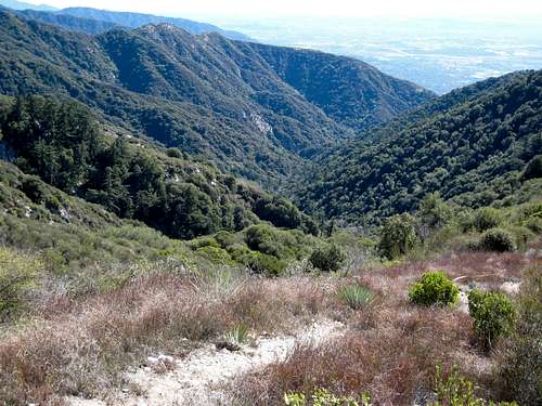
Looking down Little Santa Anita Canyon
This trailhead (elev. 970’) affords direct access to the magnificent Little Santa Anita Canyon which juts into the San Gabriel front range just above the foothill town of Sierra Madre. The beautiful Mt. Wilson Trail winds steeply up the west side of the canyon crossing over the head of the canyon before reaching the 5,715 foot summit of Mt. Wilson, 7 miles from its start.
The Mt. Wilson Trail has a lengthy history. Hundreds of years ago, it was a trail used by the Gabrielino Indians to access the San Gabriel Mountains and even beyond into the Mojave Desert. At one idyllic glen near the canyon bottom, now known as Orchard Camp, an acorn sprouted about 500 years ago right above the creek bed giving life to what is seen today as a giant oak. For the hiker, Orchard Camp is a verdant and shady rest spot on the way to Mt. Wilson.
Just a mile from the trailhead, the hiker encounters jaw-dropping views of the canyon scouring deep into the mountain. Looking over the trail’s edge to hundreds of feet of precipice below, it is hard to believe that you are not even at 2,000 feet elevation at this point. Most times of the year, you can hear and see some of the many waterfalls that tumble down the canyon bottom.

Mt. Harvard from along Mt. Wilson Trail
At 1.5 miles, you will reach First Water Junction. Going right will take down into the creek. The main trail continues to the left.
At 2.5 miles, you reach the turn-off for a connector trail that takes you to the ridge north of Jones Peak. The turn-off is intermittently marked by a small wooden sign. If you elect this option, go left off the trail into a streambed and you will find the connector about 100 yards up the streambed.

Jones Peak (3375')west of the Mt. Wilson Trail
Continuing on the Mt. Wilson trail, at about 3.2 miles, you will reach Orchard Camp. At about 5 miles you will reach the Manzanita Ridge where there is a junction with the Winter Creek Trail coming from Chantry Flat.

Winter Creek near Chantry Flat
Going left, the trail turns connects with the Mt. Wilson Toll Road in ½ mile. Follow the toll road north another ½ mile until it connects again with the Mt. Wilson Trail on the right. Follow the trail .7 miles to the summit of Mt. Wilson. Alternatively, you can continue on the toll road all the way to the summit area ending up further west than by going up the trail.

Mt. Wilson
SPECIAL NOTICE: The trail will be closed off weekdays starting December 2, 2008 through January 2009. See this San Gabriel Mountains Discussion Forum post for details.
Driving Directions
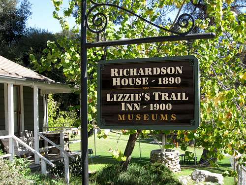 Museums at the trailhead
The Mt. Wilson Trail trailhead is located within the city limits of Sierra Madre. From the 210 Freeway, exit Baldwin Ave. and go north. When you come to a traffic light where you have to go either right or left, go left to the next light and that is Baldwin Ave. Take a right and continue up Baldwin Ave. through the downtown area of Sierra Madre. Approximately ¾’s of a mile from the downtown plaza, take a right on Mira Monte. Go down about 1/3 mile and you will come to a small park on your left. Park anywhere in this area along Mira Monte. To get to the trail, walk up the paved Mt. Wilson Road next to the park.

Lizzies Trail Inn

Beginning of Mt. Wilson Trail
Red Tape
Because the trailhead is within the city limits of Sierra Madre, no forest service parking pass is required. Note that the local police are particular about curbing your wheels so don’t risk a ticket. Hiking permits are not required.
Other Information
The trailhead is accessible year round.
Trail Race
For those wanting to move faster than the average hiker, the town of Sierra Madre hosts each May the 8.6 mile Mt. Wilson Trail Race. The race starts downtown, picks up the Mt. Wilson Trail at the trailhead, proceeds to Orchard Camp, and then back to the start. A standard feature of the race is Sierra Madre Search and Rescue personnel on hand at the most exposed parts of the trail ready to deal with any mishaps.
Canyoneering
For those wanting to explore the canyon bottom, there is a convenient jumping off point 1.5 miles along the trail at “First Water,” elevation 1,920 feet. Descending the canyon from First Water garners an American Canyoneering Association rating of 3C III. You will need appropriate canyoneering gear and will encounter about 8 rappels. For route and other details see Brennan’s chapter on Little Santa Anita Canyon in his Adventure Hikes and Canyoneering in the San Gabriels.
USGS Topos7.5 Mt. Wilson
External Links
History of Mt. Wilson Trail
Brennan’s chapter on canyoneering in Little Santa Anita Canyon
Angeles National Forest
San Gabriel Mountains Discussion Forum