
-
 1583 Hits
-
 77.48% Score
-
 8 Votes
|
|
Mountain/Rock |
|---|---|
|
|
Hiking, Mountaineering, Scrambling |
|
|
Summer, Fall |
|
|
6909 ft / 2106 m |
|
|
Overview
Montscheinspitze or Mondscheinspitze is a separately standing summit within Karwendel Prealps of the Karwendel area and the highest one of these “prealps”. Located between Pertisau / Pletzach valley to the east and southeast and Eng valley to the west and northwest, Montscheinspitze is quite a popular hike. Plumsjoch col to the southwest separates the mountain from the Schafreither – Kompar subrange north of Eng valley and from the Sonnjoch subrange to the south. Schleimssattel separates Montscheinspitze from the Seekarspitze – Seebergspitze and Sonntagsspitze – Juifen subranges to the east and the north.


The denomination is quite confusing. Mondschein means moonlight but Montscheinspitze means not moonlight peak, however poetic this will sound. One of the three subpeaks of Montscheinspitze is called Der Mantschen. It is the culmination point of the northeast ridge of our summit. In fact the summit must be named Mantschenspitze and Mantschen comes from romanic monticinu and means small and steep alpine meadow. If you look at Der Mantschen you will understand …
The other two subsummits are called Der Kotzen, another strange word (not meaning to vomit; it derives from "cozzo" which means a rough woolen plaid) and culmination point of the northwest ridge and Montscheinjoch or Plumsjoch summit, sitting on the south ridge to Plumsjoch col.


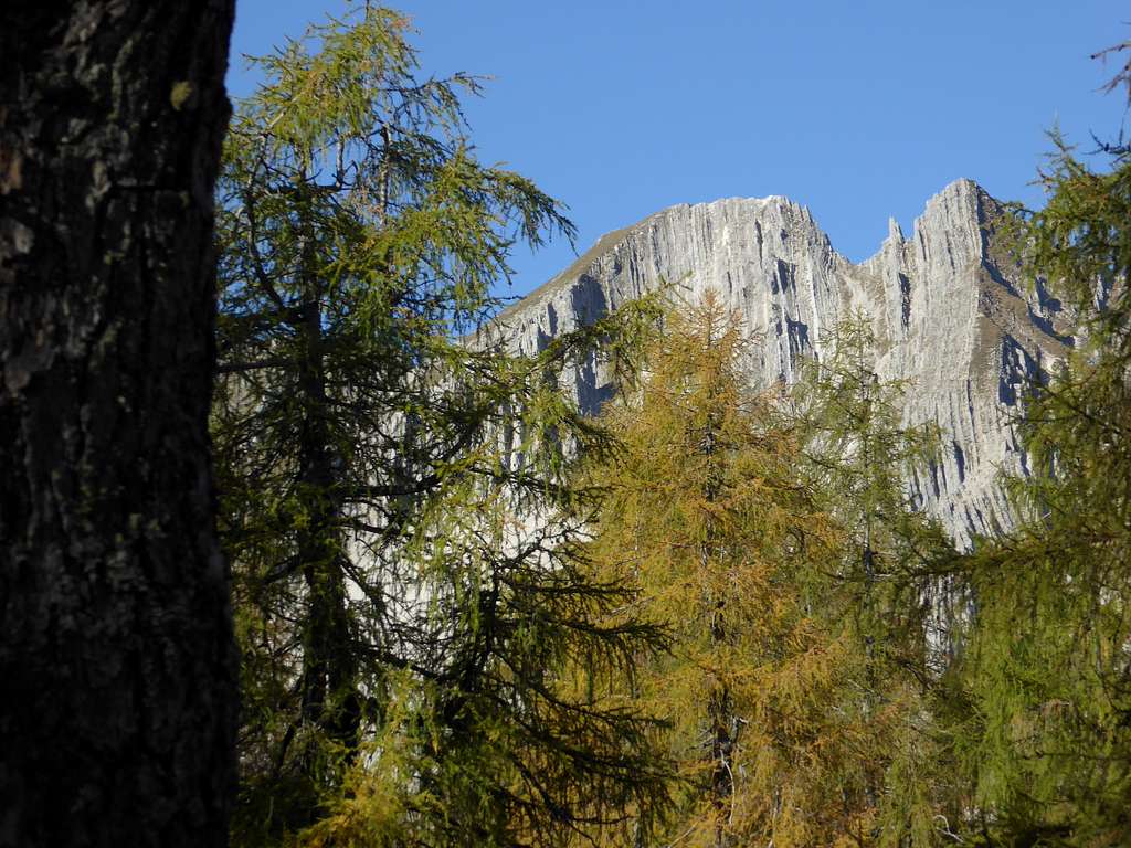
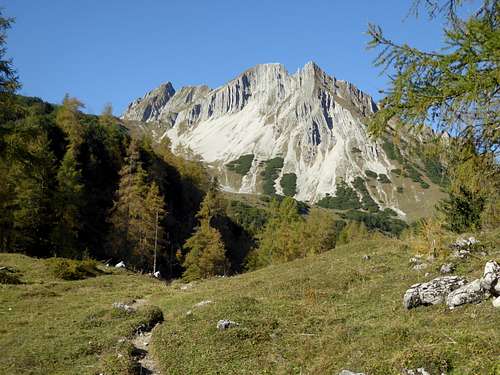
Geologically Montscheinspitze consists of the so called Plattenkalk, a fine bedded limestone of Triassic age. The forces of orogenesis pressed these beds in a near upright position which gives the mountain an impressive look when viewed especially from the east.
The traverse of Montscheinspitze from and to Pletzach valley is one of the best undertakings within Karwendel Prealps. On a fine and warm autumn day you will find this outing – despite of some other co-hikers – surely satisfying.
Getting There
Trailheads are
- Pletzach valley – parking area between Pletzachalm and Gernalm to the east;
- Gernalm parking area in the same valley;
- Hagelhütten parking area within Eng valley to the west.
You reach Pletzach valley near Pertisau / Achensee
by car on highway A 12, from Innsbruck or from Munich / Salzburg; leave at exit "Wiesing / Achsee" for Maurach on road number 181; at Maurach follow signposts to Pertisau and at Pertisau to the Karwendel valleys (toll road); at the first road junction go straight on, pass by Pletzachalm inn and take the first parking area on the right. Best parking area for the traverse.


Alternatively follow the toll road until you reach Gernalm with its parking area.
by train to Jenbach railway station; check the ÖBB schedule here, then change to Achenseebahn or bus 4080 from Jenbach to Maurach and number 9550 to Pertisau; there is, however, no public transportation into Pletzach valley.


You reach Eng valley by car
from Munich via Bad Tölz, Lenggries, Fall, Vorderriß, Hinterriß (road numbers B13, B307) and the toll road to Engalmen until you arrive at Hagelhütten (parking area);
from Innsbruck via Seefeld, Mittenwald, Wallgau, toll road to Vorderriß, Hinterriß and the toll road to Engalmen until you arrive at Hagelhütten;
from Garmisch-Partenkirchen via Klais, Wallgau (roads number B2, B11), toll road to Vorderriß, Hinterriß and the toll road to Engalmen until you arrive at Hagelhütten.
You can reach Eng valley from Munich by rail and bus, too. Check this possibility here.
Routes Overview
Montscheinspitze Routes Overview
East route:
Start at Pletzach valley parking area and follow the forest road to the north. Go right after crossing Pletzach creek, go right again at the next forest road junction and ascend in some switchbacks to Schleimssattel. Go left there on a forest road and left again when a trail branches off the forest road (signposts). Follow this trail up to the east ridge of Montscheinspitze. Traverse level, descend into a steep ravine and follow the trail with some nice scrambling action in steep zigzags up to the summit. Spectacular views on this route.


South routes:
Starting at Gernalm follow the forest road to the west ascending to Plumsjoch col. A short descent from Plumsjoch col leads you to Plumsjochhütte, an alpine mountain hut.
Alternatively start at Eng valley / Hagelhütten. Cross Rißbach creek on a bridge, turn right, cross Plumsbach creek on another bridge and take the trail up to a forest road. Turn left on that road and follow it up to Plumsjoch col.
For the summit turn right at Plumsjoch col on a trail, ascending to Montscheinjoch / Plumsjoch summit, the subsummit south of Montscheinspitze. Descend shortly into a col and ascent the broad and rocky south ridge of Montscheinspitze. There is some steep and exposed rock scrambling required. Steel cables secure the most difficult sections.


My favourite is the traverse, east route up and south route down to Gernalm. A good dirtroad connects Gernalm and Pletzach valley parking area; you don´t need to follow the toll road.
I don´t know any ski tour or snow shoe routes for this mountain.


Red Tape & Accommodation
Montscheinspitze is part of the Alpenpark Karwendel.
Alpenpark Karwendel is an important and strictly protected national park.
There is no entrance fee for the park but many regulations to follow.

There is a National Park Information Center at Hinterriß / Eng valley. Information panels, starting at the parking area of Engalmen, show some interesting features of the Alpenpark Karwendel.
Camping is not allowed within Alpenpark Karwendel.
Motorhomes and caravans are tolerated only at the parking area of Engalmen.

Accommodation can be found at:
Mountain huts and valley inns:
Gear & Mountain Condition
Montscheinspitze is a hiking summit. It requires rock scramble abilities up to UIAA grade I, slighty more difficult parts on the south ridge are secured with some steel cables.
Montscheinspitze is an outing for late spring, summer and autumn until the first snowfall.
You need hiking gear and abilities in easy rock up to UIAA grade I. As the secured parts on the south ridge are very short, self belay is not necessary.

The weather at Pertisau:
Maps
Alpenvereinskarte
Karwendelgebirge, Mitte
Scale 1 : 25.000, with UTM grid
Deutscher Alpenverein, edition february 2015
Alpenvereinskarte
Karwendelgebirge, Ost
Scale 1 : 25.000, with UTM grid
Deutscher Alpenverein, edition december 2015