
|
|
Mountain/Rock |
|---|---|
|
|
37.96210°N / 107.6397°W |
|
|
Ouray |
|
|
Hiking |
|
|
12801 ft / 3902 m |
|
|
Overview
While only 12801 feet, Mount Abrams prominence and distinctive profile when viewed from Ouray make the peak very compelling. Mount Abrams is connected by a long ridge to Brown Mountain. There are nine "peaks" along this ridge with the lowest point being 12450. Reports indicate that there are concerns over private property issues to the peak from Brown Mountain jeep road and along the western flanks, I did not see any signs of private property when accessed from near Crystal lake, however there is private property markers along Brown Mountain jeep road (but nothing to hinder an ascent).Mount Abrams is likely named for an early Ouray pioneer by the name of Abram Cutler.
Mount Abrams can be approached directly from highway 550 near Crystal Lake or from Brown Mountain jeep road at the southern end of Ironton. The more ambitious will choose to access Mount Abrams from Crystal Lake area, although from brown mountain jeep road Abrams still requires some effort since you skirt or go over several "peaks".
 Ironton area in the fall
No formal trails exist to the summit. There is scant little used trail along the western flank of the mountain. It is steep forest and tundra on the flanks. There are some trails and game trails along the connecting ridge from brown mountain.
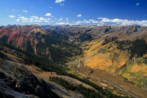
Views are standard San Juan rugged mountain views with a birds eye view of Ouray and of the Red Mountain group. Views extend to Grand Mesa and beyond to the north.
Getting There
For Crystal Lake, leave Ouray heading south on 550. Park near Crystal Lake which is the main lake in the Ironton area directly out of the Uncompahgre Gorge. 4WD is not required. Crystal lake
For Brown Mountain Jeep road, pass through most of Ironton park, go east at the southern end on a road that leads to several 4WD roads. Go north (the roads to the south go to Red Mountain). There will be two roads, one will go to Grey copper the other up the side of Brown Mountain. This road requires 4WD and will pass an old mining site.
Red Tape
The flanks of Mount Abrams create a lot of avalanches in the winter. The area of 550 entering the Uncompahgre Gorge is also the scene of many winter accidents (cars sliding off the road an into the gorge)Camping
Developed camp sites exist at Ridgway State Park and several developed campgrounds and forest service camp grounds in the Ouray and Silverton area. There are undeveloped camp sites in the area (some near the Brown Mountain Jeep road.External Links
Ouray Trails description of AbramsNWS weather forecast for 12,000 feet between Ouray and Silverton
Ouray Plaindealer article with discussion on the naming of Mount Abrams
Brown Mountain Summit Page by nader.
Route Options
The shortest access is from Brown Mountain Jeep Road. If accessing from Brown Mountain Jeep Road, access either of the two grassy drainages to the north of the pond area (around 11,600) and hike the steep slopes to the ridge, then follow the ridge to the summit. It is possible to either stay on top of the ridge and gain a little elevation and loose a little several times or to skirt the peaks on the flanks in most cases.From Crystal lake area there are several routes to the summit. One involves accessing a trail to a mining area and then ascending the grassy slopes (probably preferred) another is to head north to a drainage on the north east flanks and ascend the peak, this is a steep climb on mostly grassy slopes (stick to the grassy slopes on the northern part of the drainage). You will eventually intersect with the north ridge. This becomes a rocky talus / scree mix.