
|
|
Mountain/Rock |
|---|---|
|
|
37.82360°N / 107.9211°W |
|
|
Hiking |
|
|
12147 ft / 3702 m |
|
|
Overview
 North face of Black Face Mountain
Black Face Mountain rises above Lizard Head Pass on Route 145 in southwestern Colorado. It is surrounded by higher peaks that dwarf it. At first glance, it does not seem like a particularly interesting mountain, however, ease of access and the beauty of the area make it an ideal place to get great views of other peaks. The mountain is barely higher than treeline and has a relatively large and flat area on top where a beautiful meadow exists. I only ran into one other person when I climbed the mountain (Tuesday in July).
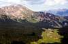
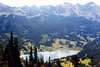
From the summit of Black Face Mountain, you can look west to see the jagged and colorful summits of El Diente (14159 ft), Mt. Wilson (14264 ft), Gladstone Peak (13913 ft) and Wilson Peak (14017 ft). The vertical horn of Lizard Head Mountain (13113 ft) appears as a giant cliff on top of a mountain. To the north, you can see Wilson Meadows as an opening in the forest at the base of Sunshine Mountain (12930 ft). In the northeastern horizon, you can probably see Mt. Sneffels (14150 ft). The eastern view reveals Trout Lake sitting at the bottom of a valley surrounded by a continuous wall of glacially carved peaks on three sides. The highest point of this wall is known as Vermilion Peak (13894 ft). Yellow Mountain and Sheep Mountain refer to other parts of the wall. To the south, you can see Lizard Head Pass and Route 145.
 |  |  |  |  |
 South/southeast face of Black Face Mountain
Getting There
From Telluride drive south on Route 145 to the rest area at Lizard Head Pass (16 miles). Parking/picnic area available at the pass. Lizard Head from Black Face
Route
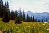
A sign in the parking lot identifies the mountains. Black Face Mountain can be seen immediately to the north. It actually looks more like a flat top mesa than a "mountain" and has steep slopes that drop to Lizard Head Pass. The summit of the mountain is directly above you but the trail will first take you behind the mountain to avoid climbing the steep slopes. It is about 3.5 miles one way. From the parking lot, the trail heads northeast following the base of the mountain through a forest of aspen on level ground. It then turns west into a valley going up in elevation and soon heads southwest making a number of switchbacks until it climbs to 11600 ft or so where you reach the flat area on top. A beautiful meadow that is filled with wild flowers and dotted with spruce trees opens up. You can look left (southeast) to see the road and the trail at the base of the mountain. You are now going parallel to but in the opposite direction of the trail down there. From here on, you will gradually go up the gentle slope and above the treeline until you reach the summit where alpine tundra covers everything.Red Tape
No permits or fees required.When To Climb
Easiest in summer.See the forecast for the nearby town of Telluride.