
|
|
Mountain/Rock |
|---|---|
|
|
36.10920°N / 118.484°W |
|
|
8254 ft / 2516 m |
|
|
Overview
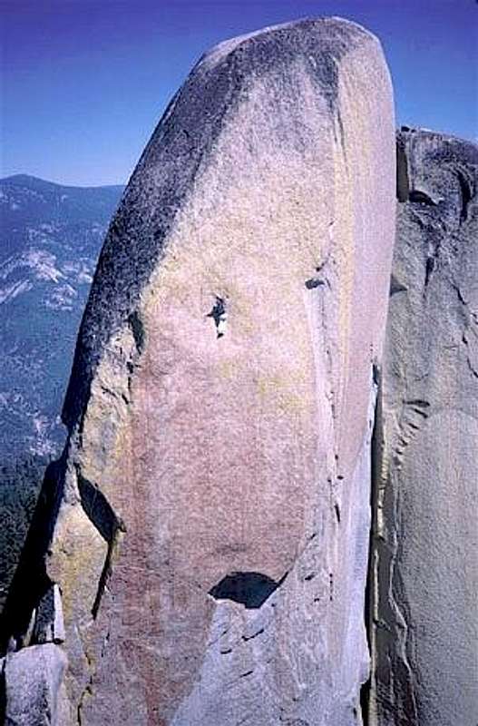
The Titanic
Rising from the North Fork of the Kern River near its junction with the Little Kern, The Needles are a series of massive granite rock formations. For climbers, they are awe inspiring and offer some of the best rockclimbing anywhere.
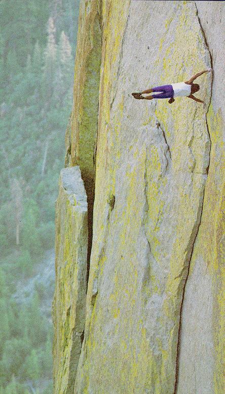
The Needles attract climbers from around the world looking to sample some of the spectacular climbs found here. The rock is unglaciated granite of excellent quality, as if it were made to be climbed! Crack climbing is what The Needles is famous for and the reputation is justified by classic routes such as Thin Ice, Atlantis, Igor Unchained, Airy Interlude and Romantic Warrior. There are some excellent face climbs as well...Love Potion #9, Scirocco, Magic Dragon, Sea Of Tranquility and The Titanic to name a few.
The first recorded technical climbing is April 1970, Fred Beckey, Dan McHale, Mike Heath climbed the South Face of the Warlock, an 8 pitch climb rated 5.9. Then in October that year, down on Voodoo Dome, Beckey and McHale climbed Pea Soup 5.9A3 which was free climbed by Tony Yaniro at 5.12a.
The Needles are often described as having a mystical aura and can be quite intimidating for many climbers. The names given to the individual formations by the early climbers -- The Magician, Djin, Charlatan, Sorcerer, Wizard, Witch, Warlock, and Voodoo Dome add to the mood.
Getting There

The Needles trailhead is located at the end of USFS road 21S05 (dirt) 3 miles from Hwy 190.
From the north- Take Hwy 190 up from Porterville past Camp Nelson and then about a half mile past Quaking Aspen campground turn left onto 21S05, It's about 60 miles from Porterville to the 21S05 junction.
Alternate route from the North
~This route is perferable over the Porterville route because it's much less windy.~
From the city of Earlimart (Hwy 99) go east on Hwy J22 to California Hot Springs, turn left on the Western Divide hwy. and continue 15 miles to 21S05 and turn right, it's 3 miles to the parking area.
From the south -You can get to hwy J22 by taking the Hwy. 65 turnoff from the 99 northbound just outside of Bakersfield. Then head north on the 65 and turn right onto Hwy J22 at the town of Ducor. It's 41 miles from the hwy. 65 turnoff to the Western Divide hwy. (M107) junction, then 15 miles to 21S05.
Alternately, - from the south you can take Hwy 178 east from Bakersfield to Lake Isabella then take
Hwy 155 to Wofford Heights and on to Kernville via road M99. From Kernville, head north on M99 (Sierra Way) to Johnsondale at which point M99 turns into M50. Continue 6.6 miles to the junction with the Western Divide hwy. (M107) and turn right. Then continue 15 miles to 21S05.
From the east- Take Hwy 178 west over Walker pass to Kernville. From Kernville, head north on M99 (Sierra Way) to Johnsondale at which point M99 turns into M50 Continue 6.6 miles to the juction with the Western Divide hwy. (m107) and turn right. Then go 15 miles to 21S05.
The hike
From the trailhead it's 2.5 miles to the Lookout. From the notch at the bottom of the Lookout stairs, take the climbers trail around the north side of the Magician Needle (some 3rd. class scrambling), then follow the trail along the north side of the ridge.
Lower approach
For routes on Voodoo Dome, Demon Dome and merlin Dome.
From Johnsondale, take Lloyd Meadow Road (22S82), about 1.5 miles past Lower Peppermint campground. Where the road crosses Needlerock creek, park in the large pullout on the right side. The trailhead is on the left side a couple hundred yards up the road from the pullout.
For Demon Dome drive another 1/4 mile to the cattleguard crossing and park in the pullout there. The trail is across the road.
Here is a map showing the Needles and the upper road (top right,21S05).
This map shows the lower road (22S82).
A Sequoia National Forest map is handy for identifying dirt roads. They are available at Forest Service offices, outdoor sports retailers or online at...USFS maps
Road info
Generally, once the road opens in the spring, it remains open, until the winter closing. Call the Forest Service for up to date road conditions.
Upper road (21S05) :
Tule River Ranger District
Springville, CA
(559)-539-2607
Lower road (22S82) :
Cannell Meadow Ranger District
Kernville, CA 93238
(760)-376-3781
Red Tape
Fire Lookout
The historic Needles fire lookout burned down in July 2011.
For more information check here...www.buckrock.org
Campfire permit
A California campfire permit is required for a fire outside a designated recreation site. A permit is available free-of-charge from any Forest Service, California Department of Forestry and Fire Protection, or Bureau of Land Management office.
Peregrine falcons
Raptors nest in the area and care should be taken to avoid disturbing them during nesting season. Any specific climbing closures are usually posted at the trail head. The nesting season is from January 1 thru August 1.
Magician, descent info
Now that the fire lookout is gone the following rappel instructions no longer apply, but the link contains information on bolt replacement activities, so is still useful. Special information regarding rappel when lookout access is closed. click here
Check the USFS website for more information on subjects not covered on this page....
Sequoia National Forest
Climbing Guidebook
The Needles Guidebook is currently out of print and unfortunately used copies are hard to find.
SoCal Select offers information and some good topos for a nice selection of climbs.
This webpage has good info and a selection of topos that can be downloaded.
Probably the best source is this mini on-line guide. (http://www.monsteroffwidth.com/NeedlesMiniGuide/index.html)
Emergency Info
Be careful! The Needles are out of cell phone range, and the closest land line is at the Ponderosa.
There may or may not be a Stokes Litter with a First Responder Kit located in the notch between Witch and Sorcerer. It used to be there all the time, and was kept stocked by the Southern Sierra Climbers Association, but it is uncertain if it will still be maintained, as the SSCA is no longer active.
When To Climb
Climbing season at the Needles is from late May through November depending on when the road is open.
Road 21S05 is closed in winter due to snow. Usually from the end of November through mid' May. If you plan on skiing or snowshoeing in, you will have to add 3 miles to the usual 2 mile approach. The lower road (21S12) usually opens around mid' April. Road information is available from the Kernville Ranger station at (760) 376-3781 or the Porterville station at (559) 784-1500.
Mountain conditions
![]()
ClimbingWeather.com
Camping
Main Needles upper area:
Quaking Aspen campground is 1/2 mile west of road 21S05 on hwy 190. 32 sites. Water and vault toilets. $14.00 per night.
Most climbers camp at Needles Spring, located at the end of the road 21S05. There are 8 developed sites with benches and fire rings. No water is available. There is a restroom located at the end of the road. There is no charge for camping here.
Lower road areas:
Camping for the lower approach to the Needles and Voodo Dome may be had at several nice locations along road 22S82.
1) Lower Peppermint Creek Campground - this is a developed campground about 1.5 miles south of the Needlerock Creek parking area campground with parking spaces, tables, fire rings, outhouses.
2) Peppermint Falls primitive camp - about 1 / 4 mile northeast of Lower Peppermint There is a primitive camping area near the top of Peppermint Falls. There is room for several parties to spread out, but no tables. Primitive fire rings at many sites. Nearby Peppermint Falls has swimming holes - above the falls can be dangerous in early season.
3) Needlerock Creek parking - this is a simple bivouac site. Just below the parking are a few tent flats.
4) The Ledge - this is a sparse bivouac site in a spectacular location east of Voodo Dome and Demon Dome. The road crosses a cattleguard while traversing east beneath Voodo and Demon, then turns north. At the point the road turns north, there is a rock outcrop that overlooks the Kern River Valley. There are a couple flat spots on and near the outcrop, with spectacular views up and down the valley.
5) Continuing north past Merlin Dome and Pyles Camp (private) you can also camp on a spur road near the George H.W. Bush Tree, a splendid lone Sequoia in the valley between the Needles and Merlin dome.
Thanks to Tom Kenney for the lower area camping suggestions.
 |
 |
Camping supplies, groceries, food.
The closest potable water is available at Quaking Aspen campground.
The Ponderosa Lodge, (559)-542-2579
Dining/refreshments, gas, groceries, Nordic ski rentals, lodging, and pay phone.
(1 mile east of road 21S05 on hwy 190)
Hermit Spire
The Hermit Spire, a neighbor to the Needles, sits on the ridge across Freeman Creek canyon just to the north, and is visible from the Needles. Perhaps the name "Hermit" was given because it looks like it should be part of the Needles group but sits alone on the opposite ridge all by itself.
For approach directions check the "Jazzing" route page.
Map ~ (note: It's called Hermit "Rock" on this map.)
Several routes have been submitted by Asmz.....
Jazzing
Water From The Moon
Wide Eyed And Willing
 |
 |
 |
 |
Routes overview
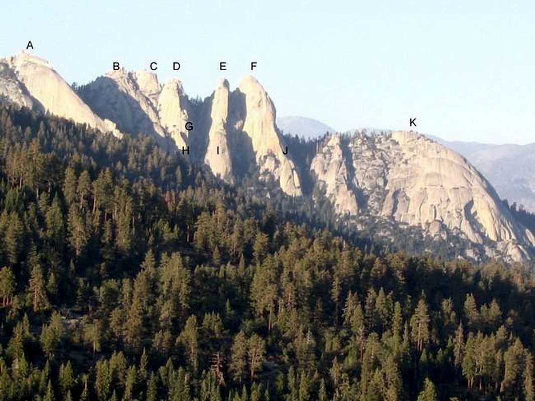
Photo above: The Needles viewed from Dome Rock.
A. Magician B. Djin C. Charlatan D. Sorcerer E. Witch F. Warlock G. Wizard F. Sorcerers aprentice I. Necromancer J. Styx K. Voodoo Dome
~~~~~~~~~~~~~~~~~~~~~~~~~~~~~~~~~~~~~~~~~~~~~~~~~~~~~~~~~~~~~~~~~~~~~~~~~~~
Only routes that have a been submitted with a route page are listed.
The formations are in bold, with routes listed underneath.
Sorcerer
Thin Ice 5.10
Ice Pirates 5.11b
Witch
Igor Unchained 5.9
Warlock
Bird of Prey 5.11b
The Howling 5.10a
Voodoo Dome
White Punks on Dope 5.8
Merlin Dome
Left is Right 5.4
The Right Side 5.6
External Links
- 1988 Hermit Spire TR
1988-1989 Trip Report To Hermit Spire describing several FA - Dan Osman photo
- USFS website
Sequoia National Forest - A Wintertime Hike to the Needles
- Southern Sierra webcams
tarol - Jan 6, 2006 2:55 pm - Voted 10/10
Untitled CommentWhen camping at Needles Spring or the dispersed areas along the Lloyd Meadow Road, you will need to have a campfire permit to have a campfire or charcoal barbeque. Also, in mid- to late- summer some years, campfire restrictions may be in place and you may not be allowed to have a campfire in these areas. Check with the Springville or Kernville Ranger Station before you go and pick up a permit there.
tarol - Aug 22, 2006 3:58 pm - Voted 10/10
More Info on Needles Fire LookoutMonday and Tuesday are the lookout's days off, also the tower may be closed for visitors during times of fire activity. The Tower was built in 1937 by the CCC.
ecjoe - May 27, 2008 2:57 am - Hasn't voted
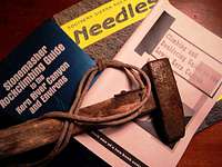
Original Guidebook AvailableStonemasher Rockclimbing Guide to the Kern River Canyon and Environs, by E.C. Joe & Dick Leversee, Copyright 1983 by E.C. Joe & Dick Leversee, All Rights Reserved, 1st edition. 141 pp, topos, is available on CD as an 'eBook' in .pdf format. http://stores.ebay.com/vertical20
Bob Burd - Oct 17, 2012 12:49 pm - Hasn't voted
Lookout gone...The page should probably be updated to point out the lookout tower burned and has since been removed (leaving the stairway).
asmrz - Jan 3, 2022 4:47 pm - Voted 10/10
Kris Solem's NEW GuidebookThe current guide book as of 2016 is "The Needles Climbing, A Complete Guide" by Kristian Solem, available online. An older guide to the area, "Southern Sierra Rock Climbing: The Needles Area," by Moser, Vernon, and Paul, has been out of print for some time now and is a hard to find item. Please include the info on the Main Needles page. Thanks, Alois.