
-
 7451 Hits
-
 87.31% Score
-
 24 Votes
|
|
Mountain/Rock |
|---|---|
|
|
46.69010°N / 12.45350°E |
|
|
8641 ft / 2634 m |
|
|
Overview
 The Carnic Alps main ridge with Schöntalhöhe / Cima di Valbella in the centre The Carnic Alps main ridge with Schöntalhöhe / Cima di Valbella in the centre |
The object of this page, Schöntalhöhe (as it is spelled in German, also Schöntalhorn), is actually one of the highest summits in the western part of the Carnic Alps Main Ridge. Only 150m lower than the Carnic Alps highpoint Hohe Warte / Coglians it can be considered one of the major summits of the ridge. As for the Italian name - I had to do a quite thorough research - which came up with the obvious: Cima di Valbella, a literal translation meaning "Pretty Valley Peak".
Still it is a quiet and unknown summit, perhaps even obscure. While the southern slopes are rather shallow, Schöntalhöhe shows an impressive drop in its north face. It is located directly on the Italian - Austrian border. The long (140km = 90 miles) Karnischer Höhenweg trekking trail runs along very close to the north of the summit, while the Italian version, the "Traversata Carnica" almost touches it from the south. Like its immediate neighbour to the west, Demut / La Mutta it is marred by 90 year old trenches from World War I. At the western base of the summit block you can find the remains of an old wooden fort dating back to the war.
 |  |  |
Both routes to the mountains follow the main ridge and are best accessible from the north. Both the Hollbrucker Tal and Schustertal Valleys lead southward to the ridge where they join the Karnischer Höhenweg. While the route along the Schöntalhöhe east ridge is very short and steep the western ascent needs to climb Demut / La Mutta before cutting over to Schöntalhöhe. Part of this trail leads through the north-west faces of both mountains and runs along the old Kaiserjäger support routes of WW I. One can only admire the ingeniousness of the old pioneers - there certainly is no better way up the mountain.
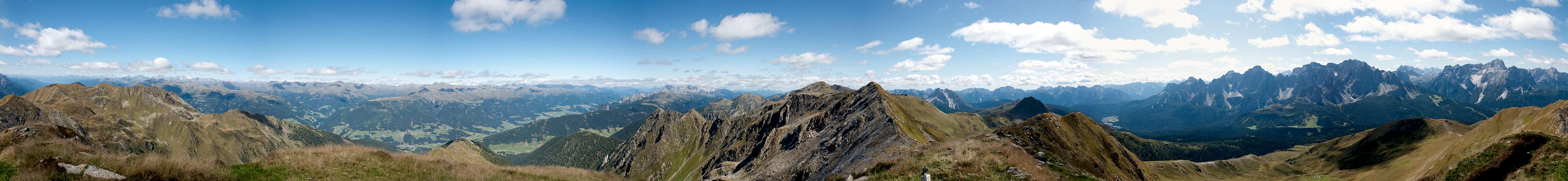
360° Summit Panorama
  |
Getting There
 The western Carnic Alps Main Ridge as seen from Gumriaul
The best starting points for an ascent of Schöntalhöhe are the villages of Hollbruck and Kartitsch in the Tyrol Gailtal Valley.
From the West (Brenner Motorway A22)
Leave the Brenner Motorway near Brixen / Bressanone and follow SS49 to the east through Pustertal / Val Pusteria. To the east of Innichen / San Candido you cross the Austrian-Italian border and follow the road (now B100) to Tassenbach. Turn right (south-east) here onto B111, which you follow in direction Kartitsch. Shortly before you reach Kartitsch a side road turns off to the right, which will lead you to Hollbruck. For the Schustertal Valley Ascent park your car near the intersection, for the Hollbrucker Tal Valley Ascent follow the side road to its end in the hamlet of Hollbruck.
From the North
There are two possible roads:
- From Kitzbühel over B108 through the Felbertauern Tunnel to Lienz, then southwest to Tassenbach (B100), where you turn on to B111 east into the Tyrol Gailtal.
- From Salzburg along motorway A10 to Spittal. Turn west on B100 to Oberdrauburg, there south to Kötschach-Mauthen were you turn east on B111. You need to go through the whole Lesachtal Valley to reach Kartitsch. Shortly afterwards turn to the left in the direction of Hollbruck. For the trailheads see above.
From the South (Udine)
Take Motorway A23 to the exit Camia Tolmezzo. Follow SS52 north to Tolmezzo where you turn onto SS52 bis. This leads to Plöckenpass, where it crosses the Austrian-Italian border. In Austria the road turns into B100 and at Kötschach-Mauthen you have to turn east on B111 into Lesachtal Valley. Again, go on through the whole valley to Kartitsch.
Red Tape
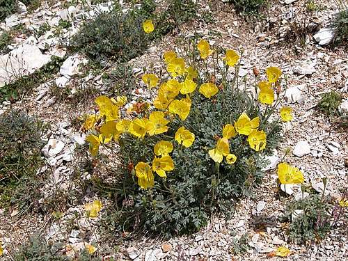 Yellow alpine poppies
There is no red tape here. No parking fees, no permits. You are on the Austrian - Italian border, however, and even in a unified Europe you should be aware of this. Keep your ID at hand.
Camping on the ridge doesn't seem to be the best idea. Rather head for the refuges (Sillianer Hütte in the west, Obstanser See Hütte in the east) or do the ascent as a day tour from the villages in the valleys down below. For info on the refuges, take a look at the corresponding section on the Carnic Alps Page.
When To Climb
 Schustereck, Weißer Knoten, Wiederschwing, Schöntalhöhe and Demutspitze
The good thing about Schöntalhöhe is that it can be climbed all year round. The hiking season is May through October but like any other mountain in the western part of the Carnic Alps Main Ridge it is perfect for ski tours. Either take one of the lifts to Helm / Monte Elmo or do an ascent through one of the northern valleys.
Accommodation
As said above camping on the Austian - Italian border might not be the best idea. Near the refuges you shouldn't have problems but ask the proprietors.In most of the villages of Hochpustertal, Tyrol Gailtal and Lesachtal you can find small campgrounds, which are often associated with inns or hotels. If you are looking for hotel rooms or apartments follow one of the links below
Weather Conditions
Maps & Books
MapsI have been using maps by Kompass Verlag, which are very good for the hiking trails though they don't show ALL the relevant summits of the area.
- Lienzer Dolomiten / Lesachtal
1:50000
Kompass Map WK47
Kompass Verlag
ISBN: 3-85491-053-3
- DOLOMITI DO SESTO / SEXTENER DOLOMITEN
1:25000
Tabacco Map 010
Editione Tabacco
As for books please look at the corresponding section of the Carnic Alps page.