
-
 36488 Hits
-
 84.27% Score
-
 18 Votes
|
|
Mountain/Rock |
|---|---|
|
|
48.95445°N / 121.68199°W |
|
|
Download GPX » View Route on Map |
|
|
Whatcom |
|
|
6241 ft / 1902 m |
|
|
Overview
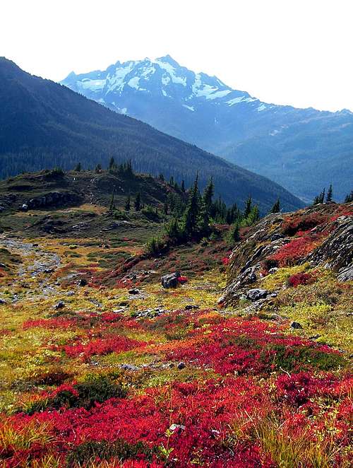
Fall Colors On The Y.A.B. Trail
Yellow Aster Butte is a gentle triple-summit peak immediately north of the North Fork Nooksack River drainage. It is located near the end of the Mount Baker Highway (Hwy 542), between neighboring peaks Goat Mountain and Tomyhoi and west of Winchester Mountain. A trail goes to the rounded south summit and from there, another lesser worn boot path traverses a saddle to a rocky knob which is the peaks highest point, the North Summit.
While not really a technical climbing objective, Y.A.B. is a very rewarding and relatively easy summit with rewarding views of Mount Baker, Mount Shuksan, The Pickets, Mount Larabee, American Border Peak, Canadian Border Peak Tomyhoi Peak, and in the distance to the west, Church Mountain.
The trip up Y.A.B. is especially beautiful in September when the fall colors are in full display and the huckleberries are at their ripest. This is probably the most popular time to hike in the area and this is one of Bellingham's best kept secrets. You would have a hard time trying to find more vibrant fall foliage anywhere else in the North Cascades.
At times during the summer months Yellow Aster Butte can be a popular destination so if you are seeking solitude, try planning your trip during a week day.

Tomyhoi Seen From Yellow Aster Butte
The Standard Route
The trail from the parking area is well defined and very easy to follow all the way to the south summit. The first half mile gradually ascends a south facing, open, brush-covered slope. The trail then briefly enters the forest as it crosses over a ridge. Turning now to the north the trail enters a sort of alpine basin where views of Mount Baker to the south begin to open up. About a mile from the trailhead there is a fork with the right branch leading up. Take the left branch. The right fork leads over Gold Run Pass and then down to Tomyhoi Lake.
Fall Colors
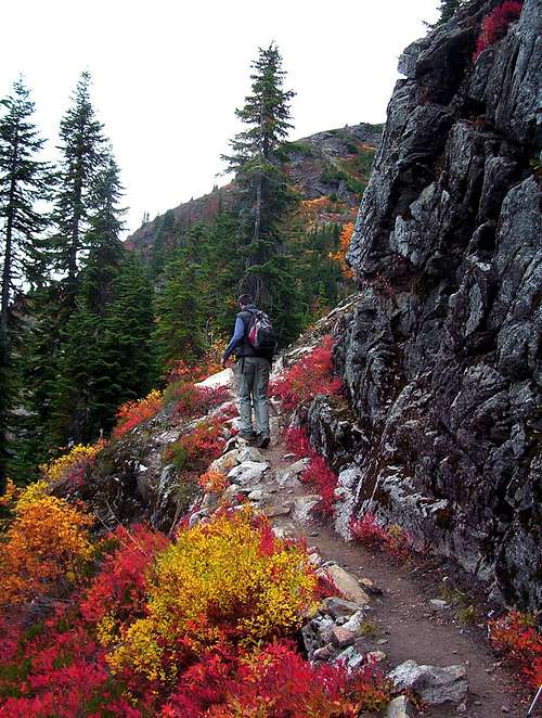
Beyond the fork the trail makes a gradual turn to the southwest, running along plentiful blueberry and huckleberry slopes. 1.5 miles from the start, the terrain briefly becomes more rocky and there might be a stream or two to cross. At two miles, the trail is directly south of the south summit crossing more blueberry and huckleberry slopes. Here the views of Mount Baker and Mount Shuksan become quite dramatic. Every time I have been on this part of the trail I have seen people with big tripods and big cameras.
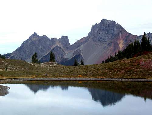 The Border Peaks
Beyond the berry slope there is another fork which is easy to miss if you don't know it is there. It's near the ledge overlooking Tomyhoi Peak and the multiple tarns down below in Yellow Aster Meadows. A small boot path switchbacks down a very steep brushy slope toward the tarns. Exercise caution here for a stumble could lead to a serious fall. This is the popular camping destination and also the standard route for Tomyhoi Peak. Even if you don't intend to camp, it's worth the extra distance to go down and inspect the high plateau.
For Yellow Aster Butte, continue on the main trail which leads in the other direction, up to the south summit. From the south summit it's another half mile to the highest point. Follow the ridge top over the middle summit. There is a little bit of exposure at one spot as the ridge top narrows but it's not bad. Near the end, the boot path goes through some small gnarled trees. If you find yourself having to use your hands, you are probably slightly off the path. Beware the northern cliff while on the summit. As you can see in this image it would be a long drop.
Driving Directions

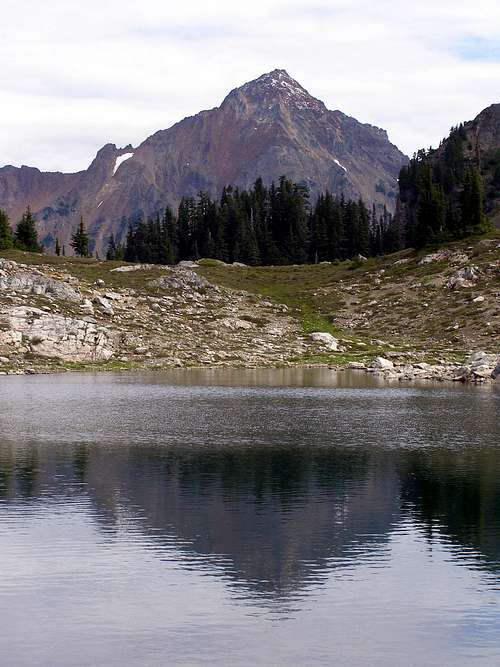
Mount Larrabee Reflected In The Tarns
From I-5, take exit 155 east and you will be on the Mt. Baker Highway. Follow the Mount Baker Highway #542 East for 46 miles. Just past marker 46, turn left on the Twin Lakes Road at the DOT Maintenance Station. The road begins at the east side of the DOT station parking lot. If you pass the Hannegan Pass Road on cross the Nooksack River, you've gone too far.
Drive the Twin Lakes Road 4.5 miles to a hairpin turn that is the parking area for the trailhead. There is a sign board here and an outhouse. The 2 mile drive beyond this will take you to Twin Lakes and the trailhead which leads to Winchester Mountain, High Pass, and Mount Larrabee. The last two miles to Twin Lakes are gnarly though and recommended only for those with 4WD and good ground clearance.
Camping / Current Conditions

Photo of Bob Bolton's camp in Yellow Aster Meadows
Since Yellow Aster Butte is an easy day hike, camping is generally not an issue. Still, the area is hard to say good bye to, so one may opt to camp. If doing so, do it at Yellow Aster Meadows with all of the tarns.
Car camping can be done a Twin Lakes 2 miles beyond the trailhead, but the road getting there requires 4WD.
Washouts and snow blockages are common in the North Cascades. Many years, the Twin Lakes road has had to be rebuilt and repaired. For current conditions visit the Mount Baker-Snoqualmie National Forest Conditions website.
Red Tape

A Northwest Forest Pass is required to park at the trailhead. A Golden Eagle Pass can also be used.
Passes can be purchased at the Bellingham REI, the Chevron Station in Maple Falls, or the Ranger Station in the town of Glacier.
If you do decide to camp in the uppers meadows, keep in mind that bears frequent the area. Please be responsible with proper overnight food storage and remember that anything that gives off an attractive odor can summon wild animals.
External Trip Reports
Make sure to take a look at some of these excellent trip reports. Once you see some more photos from this area, you won't be able to resist making the trip.
- October 2009 Trip Report
- Another October 2009 Trip Report
- September 2009 Trip Report
- September 2008 Trip Report
- Another September 2008 Trip Report
- October 2007 Trip Report
- July 2006 Trip Report