
|
|
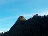
Mountain/Rock |
|---|---|
|
|
38.72710°N / 104.9222°W |
|
|
10073 ft / 3070 m |
|
|
Overview
Vigil Peak is a proud and yet often overlooked mountain outside of Colorado Springs that forms the first of four peaks that run east to west along a ridge above Bear Trap Ranch. San Luis Peak is Vigil's first neighbor to the west with McKinley Peak and Mt. San Luis following along the ridge. It stands to the north of Emerald Valley and to the south of Gold Camp Road. The summit can only be seen along the southern end of the beautiful Colorado Springs skyline for fleeting glimpses as it hides behind St. Peter’s Dome to the northeast. It soon comes into view as you make your way out of the Springs on Old Stage Road.
This is a great mountain to climb on a very well maintained trail up until the final summit spur. It is mostly class 1 and 2 hiking until the final 20-30 vertical feet at the base of the spur. At this point it is low class 5.
I attempted Vigil at the beginning of December, 2005 only to be turned around at this point due to the nature of the route and snow conditions. Personally, I have some reservations about writing a page for a peak that I did not summit. However, coming within 20-30 vertical feet of the top gives me more than a little familiarity with the mountain. Still, I won’t sign the summit log until I top this peak, hopefully in good weather next summer. For this reason I have sought the advice of fellow SPer shknbke, who has summited Vigil Peak. Kevin has been kind enough to write the most critical part of the route page for me. Without him I would not feel comfortable submitting this page. Vigil Peak is a beautiful mountain worthy of climbing on. However, I would recommend attempting her only with class 5 skills with another experienced climber and ideally in good weather.
 |  |  |
Getting There
I strongly recommend using the Pikes Peak Atlas for this route. This can be found at the Colorado Springs REI and many local bookstores. I think it is much better than the National Geo. Topo map.
Take I-25 from either the north or south to Exit 140. Go south on Rt. 115, which is Nevada Ave. Get off at the westbound Lake Ave exit. Take your second left onto Cheyenne Mt. Rd. and follow this until you come to the sign for the Cheyenne Mt. Zoo, which will be to the left. Go straight through this intersection and take Old Stage Road into the mountains. I strongly recommend using the Pikes Peak Atlas Map from this point. 6.3 miles from the point that Old Stage Road goes from pavement to dirt you will come upon the sign for Bear Trap Ranch. About 0.5 miles prior to this point Gold Camp Road will merge from the right. Take a left into Bear Trap Ranch and follow its road past the main entrance sign. Proceed down a hill until the road ends. You will see a “parking” sign to the right, but follow the sign for “registration” to the left. Pass the main office, which will be to your left, and bear to the right at a fork in the road. At the next junction you will see the large and attractive Worden Wrangler’s Lodge to your right. The trailhead is to the right and behind the lodge.
Red Tape
The trailhead for San Luis and Vigil Peaks lies on the private land of Bear Trap Ranch. However, I have personally spoken with the caretakers of the ranch and the camp coordinator and they graciously gave me permission to park on the ranch property at the base of the trail. They enjoy visitors and are fine with hikers climbing nearby peaks. That being said, I would still highly recommend asking their permission if you encounter them as you enter the property. They are very generous in allowing us to use their land and we need to honor that and adhere to the “Leave No Trace” principles.
When To Climb
Any time of the year, but be prepared for deep snow through winter and into the spring. As with any Colorado mountain be mindful of summer afternoon thunderstorms and be heading down before noon.
Camping
Camping is not allowed on Vigil Peak unless permission is given by the caretakers of Bear Trap Ranch.
Mountain Conditions
Conditions will be similar to Colorado Springs weather. There is a very well maintained trail starting at Bear Trap Ranch. However, much of your route hides your view to the west where your weather will most likely be moving in from. You will not be able to get a good view in this direction until near the summit ridge.
shanrickv - Dec 28, 2005 9:40 am - Hasn't voted
Untitled CommentThanks! I updated the coordinates. I had my Topo! coordinate preference set for degrees.minutes.minutes for some reason. Where would all of us SPers be without hgrapid to keep us and our topos in line? Probably wandering in China somewhere!:)
hgrapid - Dec 28, 2005 8:38 am - Hasn't voted
Untitled CommentCheck your topo marks. According to the distances, San Luis Peak is almost 30 miles away!
shanrickv - Dec 28, 2005 9:40 am - Hasn't voted
Untitled CommentThanks! I updated the coordinates. I had my Topo! coordinate preference set for degrees.minutes.minutes for some reason. Where would all of us SPers be without hgrapid to keep us and our topos in line? Probably wandering in China somewhere!:)
shanrickv - Dec 28, 2005 9:41 am - Hasn't voted
Untitled CommentI corrected the topos so that San Luis peak is now 1 mile, as it should be, and not 30 away from Vigil Peak.
Sarah Simon - Aug 10, 2011 10:58 pm - Hasn't voted
Bear Trap RanchHey, I posted this note on another one of your local pages: See this online letter: http://www.beartrapranch.org/bear-trap-ranch-more-info I wonder how/if this could affect access in the future. Also, it's interesting that the ranch president indicates one of their reasons for closure = they don't own the land, but have a special use agreement with the forest service. I found this curious... Anyhow, just a courtesy FYI as you have a page or two in this area and both short-term and longer-term access from the east to these peaks could be affected by this turn of events. Sarah