
-
 9068 Hits
-
 79.99% Score
-
 13 Votes
|
|
Mountain/Rock |
|---|---|
|
|
49.14471°N / 7.78853°E |
|
|
Hiking, Sport Climbing |
|
|
Spring, Summer, Fall |
|
|
1132 ft / 345 m |
|
|
Overview
 Western part of Hochstein seen from Jakobsfels Western part of Hochstein seen from Jakobsfels |
Hochstein is one of the typical sandstone "massifs" of the Pfälzerwald, the hiking, climbing and bouldering area in southwestern Germany, located closely to the French border. The word massif is used here for the long narrow sandstone ridges which cross the tops of the local mountains and stick out at either end to form impressive sandstone cliffs, towering above the valleys. The Hochstein Massif istself is a crest of more than 1km length, which are popular among climbers and hikers alike. In contrast to most of the other cliffs it forms a vertical 100m deep south face for almost its whole length making it home to (almost) innumerable climbing routes. The north faces - though not quite as pronounced offer a comparable amount of routes which, however, are hidden deep inside the forest.

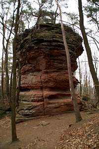
Hochsteinnadel leaning against the Hochstein Massif
The feature which sets Hochstein apart from most other Südpfalz climbing crags is Hochsteinnadel, a 60 - 80m tower (depending on the direction you start from) somehow leaning against the western end of the massif. Itself it is home to about 15 different routes, one of which is the 3m jump from the neighbouring massif! The tower is probably the most pouplar feature among climbers for its nice exposure and the interesting climbing shots which can be taken there.
But Hochstein is not only a climbing destination. You can reach the top of the ridge by a regular hiking trail. Up there you find a number of caves eroded out of the sandstone the largest of which is called "Soldatenhütte" a lookout post for soldiers during one of the wars fought between Germany and France (I forget which, however). The hiking trails stop short of the two endpoints of the ridge to the east and west. While the eastern part is comparatively easy (UIAA I) the western part includes UIAA II scrambling and a bit of jumping across deep cracks while the ridge is only a few feet across. You can't reach Hochsteinnadel without real (down) climbing however. Most hikers, however, stay on the trails which connect Hochstein with the three castle ruins above the Town of Dahn.
To the north of Hochsteinnadel is a war cemetery where 2407 soldiers are buried who have fallen in WW II. Together with the little St. Michael Chapel the cemetery is a welcome contrast to the bustle on the climbing and hiking routes.
Cimbing Routes to Hochstein
 Hochsteinnadel south face
The Hochstein Ridge is separated into four climbing areas. Rather than reprinting the copyrighted information from the site of the Vereinigung Pfälzer Kletterer I link to their routes database directly with some summary info. Here is the link t the complete database.
| Region | Routes link | Summary |
| Eastern Hochstein Massif | Hochstein East | 21 routes ranging from 2 - 9- |
| Hochsteinnadel | Hochsteinnadel | 13 routes ranging 3 - 8 |
| Hochstein South Faces | South Faces | 53 Routes with variations ranging from 1 - 8+ |
| Hochstein North Faces | North Faces | 36 routes ranging 1 - 9- |
Getting There
Hochstein is located directly above the town of Dahn, a 10 minute hike from the parking lot near the local spa hotel. Dahn itself is hidden very deep inside Pfälzerwald and tus the itineraries are a bit longish. The closest airports are at Frankfurt and Stuttgart so the itineraries start there too.From Frankfurt
There are two possible routes which both take equally long- Via Ludwigshafen
- From Frankfurt take motorway A5 southward to Darmstadt.
- There change to A67 south.
- At Viernheimer Dreieck turn onto A6 west. Leav
- e it at Frankenthaler Kreuz for A61 south.
- At Mutterstädter Kreuz take A65 south until you reach Landau.
- At Landau turn on B10 west.
- At Hinterweidental turn onto B427 south which will take you through Dahn. At the southern end of the town there is a roundabout. Take the third exit which leaves for the parking lot at the spa hotel.
- Via Kaiserslautern
- From Frankfurt take motorway A3 west
- At Mönchhofdreieck turn onto A67 south
- At Rüsselsheimer Dreieck take A60 west
- At Kreuz Mainz Süd take A63 south
- At Kreuz Kaiserslautern turn onto A6 west
- At Kreuz Landstuhl turn onto A62 south
- At Pirmasens turn onto B10 east
- At Hinterweidental take B427 south to Dahn
From Stuttgart
- Take motorway A8 to Karlsruhe
- At Karlsruher Dreieck turn north onto A5
- Tke the next exit to head for A65
- At Kandel you can leave onto B427 which will lead you directly to Dahn. However the detour to Landau and B10 will take less time as the roads are better (three or four lanes)
Red Tape
 Icicles hanging down from the Soldatenhütte cave
Yes, there is red tape and lots of it. The sandstone of Südpfalz forms lots of caves and overhangs. Though this makes it most interesting for climbers, two species of birds of prey compete for this habitat: the peregrine falcons and the eagle owls. Both are endangered and wherever there is a eagle owl pair found nesting in the sandstone the crag will immediately be closed. Generally this closure lasts from the beginning of each year through Aug. 1st. If breeding is not successful the closures will be cancelled even before that date. For a list of closures see the Closure List of PK.
The use of magnesia is not allowed in the whole Südpfalz region. This is rather a directive or an arrangement than an outright law. Thus you probably will get away with using it but do so only when absolutely necessary. Magnesia closes the pores which you find in the sandstone and together they form a smooth surface which will get very slippery in wet conditions. The rule of thumb is to use magnesia in the highest difficulty sections and only extremely sparingly.
A list of guidelines can be found here (in German).
Accommodation
In the town of Dahn you can find numerous hotels or apartments. Have a look at the tourist information site for more info. There are two campgrounds, one at Neudahner Weiher one in nearby Bruchweiler-BärenbachWeather Conditions
The closest available weather information is the one for Pirmasens (20km to the north-west):Pirmasens weather
Maps & Books
 Large house sized boulder on the east side of the Hochstein Ridge
Maps
As for maps there is a good overview map (1:50000) by Kompass Verlag but the best ones are the official topographic maps by the state government of Rheinland Pfalz, scaled 1:50000, 1:25000 and 1:5000. All official maps can be found on the web page of Landesvermessungsamt Rheinland Pfalz
1:50000
- Naturpark Pfälzer Wald
Kompass Map WK766
ISBN: 3-85491-523-3
- Pirmasens Süd
LVA RLP Map L6910
ISBN: 3-89637-193-2
1:25000
Books
here are a number of climbing guidebooks on the region of Südpfalz. The best ones, however, have been published privately and are sold only in selected bookshops of the region.
- Hiking
- Pfälzerwald
B. & J.-Th. Titz
Rother Verlag
ISBN: 3-7633-4268-0 - Klettern im Buntsandstein
U. Daigger, H.-J. Cron
Published privately and out of print
- Pfalz ++, Klettern im Buntsandstein
R. Burkard, P. Weinrich
Published privately
- Klettern im Naturpark Pfälzerwald
Naturfreunde Lambrecht
Published privately - Pfalz & Nordvogesen en bloc
A. Wenner, Y. Corby, I. Bald
Panico Verlag
ISBN: 3-936740-19-4
Climbing