
|
|
Mountain/Rock |
|---|---|
|
|
43.10000°N / 19.00000°E |
|
|
Mountaineering |
|
|
Summer |
|
|
7575 ft / 2309 m |
|
|
Overview
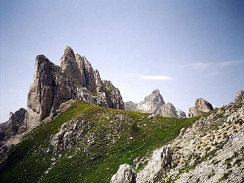
Zupci (2309 m)(Teeth) peaks are one of most specific peaks in DURMITOR. Actually, Zupci massif is structured from 14 impressive and sharp rocky "teeth", which are wide known trademark of Durmitor and it's incredible and specific beauty. What is important to know is that the summits of Zupci peaks cannot be reached by typical mountaineering and climbing. Impressive rocks and cliffs of Zupci are typical rock climbing & alpinistic challenge. Zupci belongs to those Durmitor's peaks which summits can be reached only by rock climbing & alpinism. Impressive Zupci (Teeth, 2309 m)
Zupci peaks are placed in the heart of Durmitor, actually in E-SE part of massif. Their impressive and sharp rocky peaks invites experienced rock climbers and alpinists to climb them. Zupci are surrounded by highest peaks of Durmitor. Massif of Zupci are closest neighbour to Sljeme (2455 m), Milosev Tok (2426 m), Bandijerna (2409 m) and Terzin Bogaz (2303 m). From Bandijerna, Zupci are separated by beautiful high grassy pass called Trojni Prevoj (Tripple Pass, 2245 m).
 Last light on Zupci (2309 m)
LOCATION:
Zupci peaks are placed on E from Bobotov Kuk (2523 m), Bezimeni Vrh (2487 m), Djevojka (Soa, 2440 m), Lucin Vrh (2396 m), Planinica (2330 m), Susica Canyon, Skrka Lakes Valley and Zeleni Vir Lake (Green Vortex Lake, 2028 m), on W from Sljeme (2445 m), Milosev Tok (2426 m), on SW from Savin Kuk, on S from Bandijerna (2409 m), Terzin Bogaz (2303 m), Medjed (2287 m) and Zabljak (1456 m) town, on NW from Uvita Greda (2200 m) and Sedlo Pass (Saddle Pass, 1907 m), on NE from Prutas (2393 m), Stit/Sareni Pasovi (Colorful Layers, 2248 m), on SE from Rbatina (2401 m), Minin Bogaz (2387 m), Obla Glava (2303 m), Crvena Greda (2175 m) and Cvorov Bogaz (2152 m).
SUMMIT VIEW:
W: Bobotov Kuk (2523 m), Bezimeni Vrh (2487 m), Djevojka (2440 m), Lucin Vrh (2396 m).
 Bobotov Kuk (2523 m) from near Zupci summit
E: Sljeme (2455 m), Milosev Tok (2426 m), Savin Kuk (2303 m).
NE: Bandijerna (2409 m), Terzin Bogaz (2303 m), Medjed (2287 m) and Zabljak (1456 m) town.
SE: Uvita Greda (2200 m), Sedlo Pass (1907 m).
SW: Prutas (2393 m), Stit/Sareni Pasovi (Colorful Layers, 2248 m).
NW: Rbatina (2401 m), Minin Bogaz (2387 m), Obla Glava (2303 m), Crvena Greda (2175 m) and Cvorov Bogaz (2152 m).
All of views from Zupci (2309 m) summit are nice, but the most impressive one is W summit view to Bobotov Kuk (2523 m).
Routes Overview
ACCESS:Zupci (2309) summits can be reached by using of 3 approaches. Usual route is southern approach from Sedlo Pass (1907 m) through Uvito Zdrijelo (2140 m) and then from Surutka (2042 m) basin, and also accross Trojni Prevoj (Tripple Pass, 2245 m). From Zabljak town to Sedlo Pass by car, taxi or bike. Than by walk to the foot of Zupci massif. Western and northern approach - by walk.
 Zupci (2309 m) and Bobotov Kuk (2523 m) from Trojni Prevoj (2245 m)
ROUTES OVERVIEW:
 Zupci & Bobotov Kuk
 Surutka Valley (2042 m)
 Below the Zupci (2309 m)
1. Southern (Sedlo pass - 1907 m) approach:: Sedlo Pass (1907 m) - Uvito Zdrijelo (2140 m) - Suvi Tavani: marked route. Than route continue to: Suvi Tavani - Surutka Valley (2042 m)(marked path) or Trojni Prevoj (Tripple Pass, 2245 m)(unmarked path) - Zupci (2309 m). Time to the foot of Zupci: 2 h. Then by rock climbing to the summits of Zupci peaks. Approximatelly height of Zupci rocks is about 70 meters.
2. Western (Skrka Valley) approach: Skrka Mountain Hut (1723 m) - Samar Pass (2075 m) - Zeleni Vir Lake (Green Vortex Lake, 2028 m): marked route. Route than continue by marked path to Surutka Valley (2042 m) or by unmarked path to Trojni Prevoj (Tripple Pass, 2245 m). Time to the foot of Zupci: 2h. Then by rock climbing to the summits of Zupci peaks. Approximatelly height of Zupci rocks is about 70 meters.
3. Northern (Zabljak town) approach: Crno Jezero (Black Lake, 1416 m) - Lokvice Valley (1693 m): marked route. Than by unmarked path: Lokvice Valley (1693 m) - Zelena Lokva (Green Puddle) - Suvo Lice (Dry Face) - Trojni Prevoj (Tripple Pass, 2245 m). Time to the foot of Zupci: 4h. Then by rock climbing to the summits of Zupci peaks. Approximatelly height of Zupci rocks is about 70 meters.
WATER SPRINGS:
The closest water springs to Zupci:
1. Spring near Zeleni Vir Lake (2028 m) (Green Vortex Lake, 2028 m), active till the end of August. 45 min from Zupci (2309 m).
2. Spring in Surutka Valley (2042 m) belowe Trojni Prevoj (Tripple Pass, 2245 m), active till the end of August. 45 min from Zupci (2309 m).
3. Spring "Studenac" on macadam road Zabljak-Virak-Sedlo-Dobri Do-Todorov Do-Trsa, near Sedlo Pass (1907 m), active from spring till winter. 2,30 h from Zupci (2309 m).
4. Spring in Dobri Do Valley (1838 m) near Sedlo Pass (1907 m), active till September. 2,15 h from Zupci (2309 m).
5. Spring in Lokvice Valley (1693 m), active till winter. 2 h from Zupci (2309 m).
Getting There
 Zupci landscape
 Going to Zupci
By Plane
~To Beograd (Belgrade, Serbia&Montenegro capital) airport. Than with plane to Podgorica, capital of Montenegro, or with bus or car to Zabljak town.
~To Podgorica airport. Than with bus or car to Zabljak town.
Information about flights find on the sites of JAT Airways, a former Yugoslav airlines, or on Montenegro Airlines.
By Bus
~Beograd (Belgrade)-Zabljak
~Podgorica-Zabljak
~Niksic-Zabljak
~Pljevlja-Zabljak
Buses go to Zabljak from Beograd (Belgrade) twice a day and from Podgorica, Niksic, Pljevlja and Mojkovac several times per day.
By Car
~Beograd (Belgrade)-Zlatibor-Nova Varos-Prijepolje-Pljevlja-Zabljak
~Niksic - Savnik (47km) - Zabljak (37km): 84km; Niksic to Zabljak approach from south.
~Niksic - Savnik (35km) - Zabljak (37km): 72km;
~Podgorica - Niksic (55 km)-Savnik (47 km)-Zabljak (37 km): 139 km; Add this length if you are going to Zabljak from Podgorica via Niksic. Road to Niksic from Podgorica is good.
~Podgorica - Kolasin (71km) - Mojkovac (21km) - Zabljak (67km): 159km; road is good all the way to Zabljak. Behind Podgorica (56m) you go inside Moraca River canyon (one of spectacular Montenegrin canyons). It is up to 1000m deep and has wild sides. That's spectacular drive. After that, from "Djurdjevica Tara" bridge to Zabljak - 23 km.
Camping
 Zeleni Vir (2028 m)
 Zupci from Zeleni Vir
On Durmitor exist camps in Ivan Do and Razvrsje, and few mountain huts and bivouacs:
~Hut with few small shepherd's houses in Lokvice valley
~Hut in Skrka Lakes valley (you can sleep and buy the food)
~Bivouac in Velika Kalica valley
~Hut "Stari Katun" on the road from Zabljak to Obla Glava (2303 m) peak, near Ledena Pechina (Ice Cave) - empty simply hut from wood, without service, simple conditions...
~In Ivan Do camp price for camping is 4 Euro per day.
Also, in Zabljak town you can rent private room or apartment. Price for 2-beds apartment with kitchen and bathroom: 10-12 Euro (5-6 Euro per person).
In some villages on mountain, for example in Bosaca village, you can rent a 2-beds apartment for price 6-8 Euro (3-4 Euro per person) with free milk products every day (1 liter of caw milk).
Maps & Guides
Exist three maps of Durmitor:1. Map of Durmitor Massif & Tara Canyon - 1:25000. Author: Branislav Cerovic. You can buy it in Zabljak town in almost every store. Price: 5-6 euro.
2. Map of Durmitor National Park & Tara Canyon - 1:25000. Author: Branislav Cerovic. You can buy it in Beograd (Belgrade, Serbia) in Geokarta Co, Belgrade. Price: 2 euro. This map is better than first one and include many informations and facts about routes, peaks, lakes, glacial cirques, valleys, canyons,...
3. Durmitor Mountain Guide & Map. Short mountain guide with some basic informations and facts. Author of map: Pavle S. Bandovic. Editor: "Summit" Travel Agency, Zabljak, 2005. Price of Guide&Map: 7 euro.
 Durmitor Map
Mountain Conditions
 Zupci (2309 m) from Bobotov Kuk (2523 m)
The best weather forecast on Internet for Durmitor (Zabljak town) and Zupci (2309 m) is VREME YUBC NET site. You can see 5 days forecast for Durmitor area, 4-times-daily forecast.
Red Tape
No fees or extra fees for entering the National Park.No permits needed either.
Usual rules of behaviour for NP's do apply.