
|
|
Mountain/Rock |
|---|---|
|
|
46.13240°N / 11.28888°E |
|
|
Trentino |
|
|
Hiking |
|
|
Spring, Summer, Fall, Winter |
|
|
6545 ft / 1995 m |
|
|
Overview
Dosso di Costalta 1955 m
Dosso di Costalta 1955 m is the highest elevation of the small Costalta chain, located in the Western Lagorai, and lies between two valleys: the small Valle dei Mocheni to the East, the largest Altopiano di Pinè to the West.
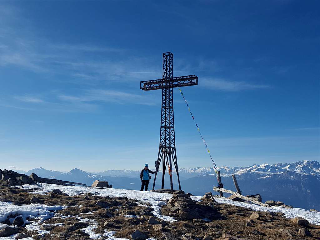
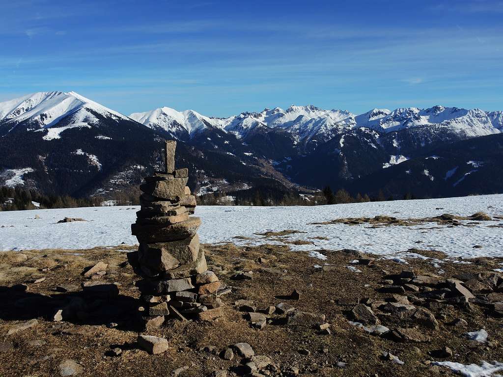
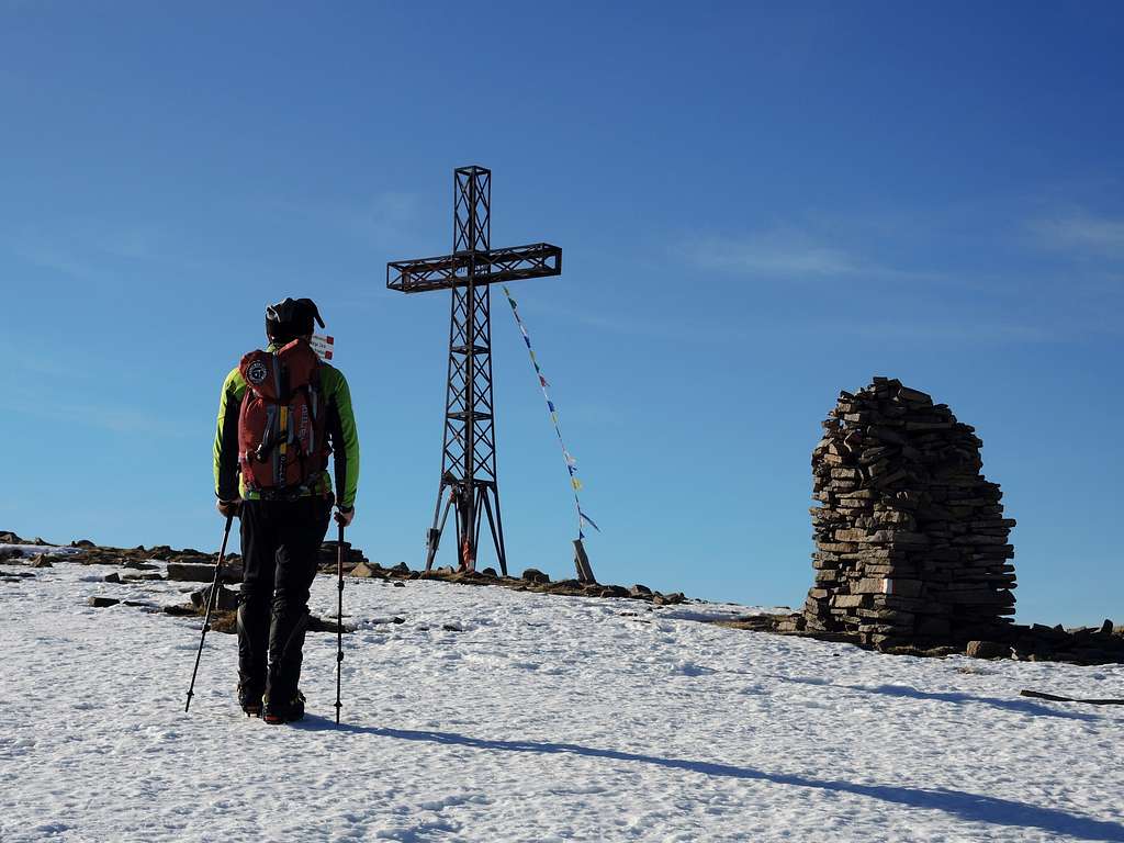
It is an easy rounded summit with an elongated shape attainable by a fairly short climb starting from Passo Redebus. This alpine col separates Dosso di Costalta from the chain of Monte Ruiòch. The summit of Dosso di Costalta is marked by a huge metal cross and the many cairns scattered all around.
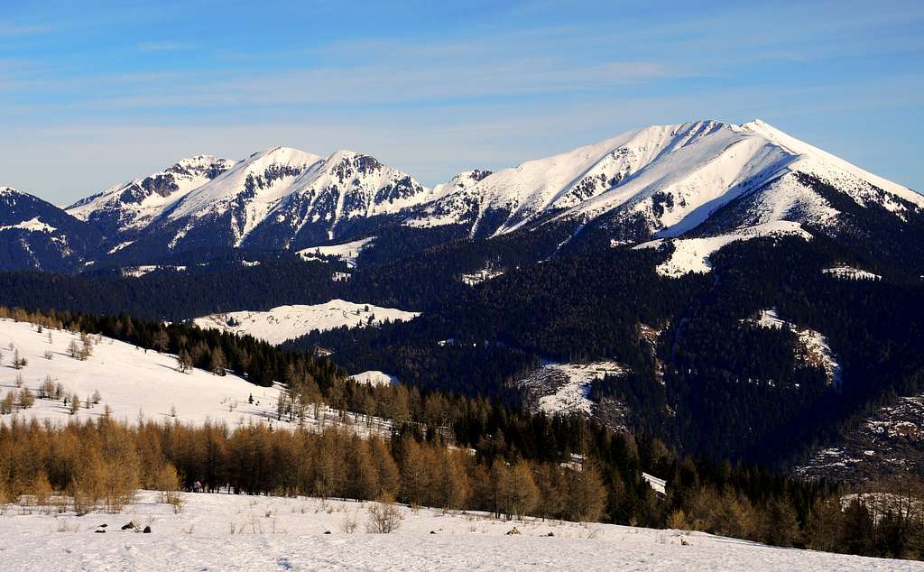
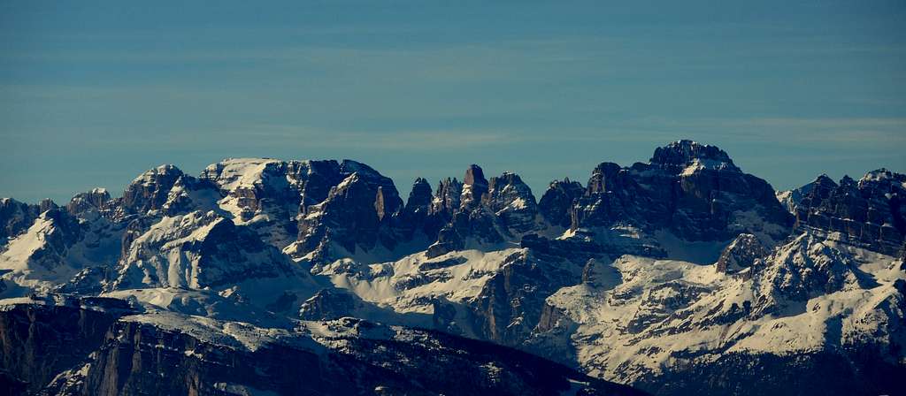
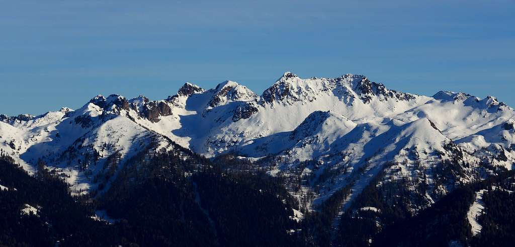
The Normal route to Dosso di Costalta, starting from Passo Redebus, is particularly advisable in reason of the panorama that is enjoyed from the summit, which touches without reaching the 2000 meters. In fact the width and flat summit, dominating the Serraia Lake, in the clear days offers a vast and spectacular panorama above the nearest mountains belonging to the Lagorai chain to the East and also above more distant chains such as the Brenta Group, the Ortles-Cevedale and the Adamello-Presanella towards the West.
Getting There
The starting point to climb the Normal route is Passo di Redebus .
•by car: using the autoroute A22 (Brennero-Modena): get out at Trento Centro and follow SS47 (Valsugana) till Pergine Valsugana, then along the SP8 (Valle dei Mocheni-Palù del Fersina); follow on the left the SP 228 for reach the Passo del Redebus (small parking area). For the distance Pergine-Palù del Fersina-zone of the Passo Redebus you can use the external link Viamichelin.
•by train: Trento station (railway Monaco-Roma) - Pergine Valsugana Station (railway Valsugana, Trento-Venezia). Info: 1678/46047 - web site in italian Trenitalia-IT.
•by bus: using the public services of Società Atesina (a branch of Trentino Trasporti) starting from Trento or Pergine.
•nearest airports: in Verona Aeroporto Valerio Catullo; in Venezia Aeroporto Marco Polo; in Milano Aeroporti di Linate e Malpensa; in Bergamo Aeroporto Orio al Serio; in Bolzano-Bozen Aeroporto di Bolzano.
Standard route from Passo di Redebus
Dosso di Costalta standard route from Passo Redebus
Summit quote: 1955 m
Difficulty: EE
Difference in level: 500 m
Starting point: Passo Redebus 1455 m
This itinerary is an easy route, suitable for everyone, with modest vertical gain, and can be safely traveled over the winter and generally sure also after conspicuous snow-fall, ideal with “ciaspole” (snowshoeing) or on foot or with crampons, depending by the snow condition. Obviously with the March month it begins the more propitious period for the ascents: the snowy mantle is generally orderly, the less rigid temperature and the hours of light to disposition last until late afternoon. The section of the classic itinerary located inside the wood upstream of Malga Cambroncoi have been modified due to the effects of the Vaia storm in October 2018. It has been redesigned due to the many trees that have fallen and marked with new temporary signposts.
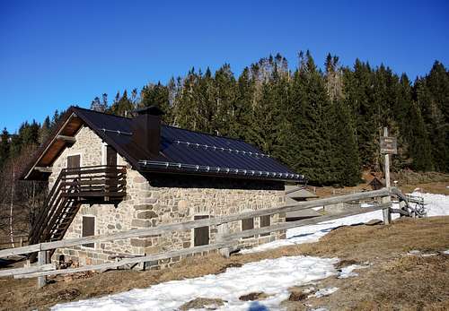
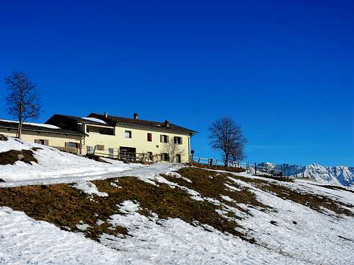
From the Plateau of Piné or from the Mocheni Valley catches up the Passo Redebus at the altitude of 1455 m. Park the car in a parking lot near the start of the trail. Leave the car in proximity of the pub and approximately 300 meters to the North of this last, near one of the warehouse large squares teke the path 404, going up quickly in the forest. Alternatively follow the forest road. In both case you will reach in approximately 20 minutes the Malga Pez m. 1706 – a nice mountain alm (m 1583) - with beautiful blow of eye on the Mocheni Valley and the unmistakable tops of the Gronlait and Fravort. From this alm the itinerary proceeds in the forest. Continue along the path 404 which climbs up behind the hut and enters a beautiful coniferous forest. Here, especially in case of fresh snow and in the absence of an obvious trace, attention must be paid to the signs on the trees. The path gets the great glade of Malga Cambroncoi m. 1706 – another Mountain alm - where the path joins the forest road. Above the alm the climb in the forest until the large plain named Prà Della Casara as mentioned has been modified. It joins the old itinerary exit at the exit from the wood in the Prà della Casara, from which the top is reached in 5 minutes, with the great cross in iron, heaps of stone and rests of trenches of the First World War. The panorama is to say little shocking. In alternative to path 404, species in the case of high snow, when it can be difficult to follow the path, it can be entire covered the forest road from the Redebus Pass to the second alm.
Descent: the return happens along the same route of the climb.
Italian version
Questo itinerario è un percorso facile, adatto a tutti, con modesto dislivello, percorribile in sicurezza durante l'inverno e generalmente sicuro anche dopo cospicue nevicate, ideale con ciaspole o a piedi o con i ramponi, a seconda dalle condizioni della neve. Ovviamente con il mese di marzo inizia il periodo più propizio per le salite: il manto nevoso è generalmente ordinato, la temperatura meno rigida e le ore di luce a disposizione durano fino al tardo pomeriggio. Il tratto dell'itinerario classico situato all'interno del bosco a monte di Malga Cambroncoi è stato modificato a causa degli effetti della tempesta Vaia dell'ottobre 2018. È stato ridisegnato per i numerosi alberi caduti e segnalato con nuove indicazioni temporanee.
Dall'Altopiano di Piné o dalla Valle dei Mocheni si raggiunge il Passo Redebus a quota 1455 m. Parcheggiare l'auto in un parcheggio vicino all'inizio del sentiero. Lasciare l'auto in prossimità del pub e circa 300 metri a nord di quest'ultimo, nei pressi di uno dei grandi piazzali, si imbocca il sentiero 404 che sale rapidamente nel bosco. In alternativa seguire la strada forestale. In entrambi i casi si raggiunge in circa 20 minuti la Malga Pez m. 1706 - una bella baita di montagna (m 1583) - con un bel colpo d'occhio sulla Valle dei Mocheni e le inconfondibili cime del Gronlait e del Fravort. Da questa baita l'itinerario prosegue nel bosco. Si prosegue lungo il sentiero 404 che sale alle spalle del rifugio ed entra in un bel bosco di conifere. Qui, soprattutto in caso di neve fresca e in assenza di una traccia evidente, occorre prestare attenzione alla segnaletica sugli alberi. Il sentiero raggiunge la grande radura di Malga Cambroncoi m. 1706 - un altra grande baita di montagna - dove il sentiero si unisce alla strada forestale. Come detto a monte del rifugio è stata modificata l'itinerario nel bosco è stato modificato. Si unisce al vecchio itinerario uscendo dal bosco nell'ampio pianoro detto Prà della Casara, da cui si raggiunge in 5 minuti la cima, con la grande croce in ferro, cumuli di pietra e resti di trincee della Prima Guerra Mondiale. Il panorama è a dir poco scioccante. In alternativa al sentiero 404, specie in caso di neve alta, quando può essere difficile seguire il sentiero, può essere percorsa interamente la strada forestale dal Passo Redebus fino alla seconda baita.
Discesa: il ritorno avviene per lo stesso itinerario della salita.
Summit panorama
Below, in underscore, you can get the links referred to the actual situation into SummistPost site regarding the tops visibles:
•Monte Stivo •Tre Cime del Bondone •Palon del Bondone •Monte Casale •Cornone di Blumone •Carè Alto •Paganella •Cima Tosa •Cima Brenta •Presanella •Monte Vioz •Cevedale •Cima Sternai •Cima Gioveretto •Orecchia di Lepre •Gruppo Palla Bianca •Similaun •Stubaiern Alp •Monte Roen •Tribulaun •Monti Sarentini •Zillertaler Alpen •Alpi Aurine •Corno Bianco •Corno Nero •Latemar •Catinaccio •Monte Cogne •Pala delle Buse •Cima Fregasoga •Monte Rujoch •Monte Conca •Cima Palù •Cima Sette Selle •Sasso Rotto •Sasso Rosso •Cima Cavè •Cima del Lago •Hoabonti •Gronlait •Fravort •Panarotta •Pizzo di Levico •Spiz (Spitz) Tonezza •Gruppo del Carega •Pasubio •Becco di Filadonna •Vigolana •Marzola •Monte Baldo •Altissimo di Nago
Red Tape
The road from Passo di Redebus can be used by mountain bike to reach the Malga Pelz (open in summer); brave MTB lovers can straight ahead till Malga Cambrocoi.
•Pay attention: the access with private cars is restricted!
Hiking and scrambling grades of difficulty
T - Turistico (Tourist): Itineraries on wide, clear and well worn paths, sometimes on mule tracks or gravel roads. The routes are never exposed, don't give any orientation problems and don't exceed 2500 meters of altitude. Suitable also for children.
E - Escursionisti (Hikers): Itineraries on marked trails, even narrow and with possible steep and impervious sections. They are never exposed and don't give any orientation problems. They can tread different kinds of ground, such as forests, gravel, meadows, pastures, easy rocks, etc.). They form the majority of the trails that wind up in the mountains and require a certain habit to walk; you need equipment suitable for the altitude and resistant footwear with soles suitable for rough terrain.
EE - Escursionisti Esperti (Experienced Hikers): Itineraries for hikers with experience and good knowledge of the mountain. Some of these paths may have exposed sections, however brief, which require firm foot and no dizziness. They require the ability to adapt to particular terrain, such as steep grassy slopes or stretches of rocks with difficulties that can reach the 1st degree of the UIAA scale. They can also reach high altitudes (3000 m or more). Sometimes they may include unmarked sections, requiring a good sense of orientation. Snow slopes are possible, however which can be overcome without specific mountaineering gear (rope, harness, crampons, ice-axe).
EEA - Escursionisti Esperti con Attrezzatura (Experienced Hikers with equipment - The same as EE, in addition these routes require the use of via ferrata equipment (lanyards, harness, carabiners, heat sink, helmet). This kind of itineraries range from the trails with short easy and not much exposed sections, previously equipped with fixed ropes and iron pegs, to the true and more difficult Via Ferratas climbing on rocky walls or on aerial ridges and ledges, previously equipped with long stretches of iron ropes, iron steps, ladders without which proceeding would constitute a real climbing. It is necessary to know how to use the technical equipment and have a certain habit of exposure and mountaineering terrains.
Maps and books
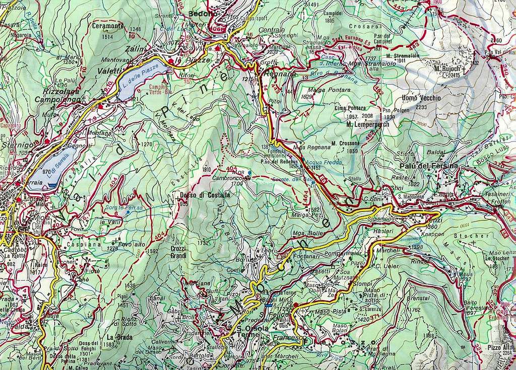
Advised cartography:
Kompass map 1:35,000 number 075 Altopiano di Pinè
Others cartography:
Kompass map 1:25,000 number 621 Valsugana - Tesino
Kompass map 1:25,000 number 647 Trento e dintorni
Meteo
External links
•local tourist office