
|
|
Mountain/Rock |
|---|---|
|
|
42.51484°N / 19.77758°E |
|
|
Mountaineering |
|
|
Summer |
|
|
8038 ft / 2450 m |
|
|
Overview
 Maja Vukoces and Zastan from Grbaja Valley
When you entering in the Montenegrin part of PROKLETIJE range, precisely in Grbaja Valley, your attention will for sure attrack one impressive peak on the end of that valley. That is Maja Vukoces (2450 m) (Vukocki Vrh) peak which with it's "Cobra" outlook proudly dominate above the green beauty of Grbaja Valley. Maja Vukoces is placed above Zastan (1600 m) high plateau, on the SW part of Grbaja Valley.
Maja Vukoces is located in the Montenegro-Albania border zone, on Albaninan side of Prokletije range, but people mostly try to climb that peak from Grbaja Valley via Zastan plateau, from Montenegrin side of Prokletije range. Maja Vukoces is surrounded by many high and impressive peaks. It's closest neighbour are Maja Shkurt (2499 m), Maja Lagojvet (2466 m) and Maja Shnikut (2554 m) on S side, Forza (Maja Fortit, 2340 m) and Maja Scokista (2396 m) on SE side, Karanfili (2460 m, 2490 m, 2441 m) on NE side and Vojusa (Maja Vojusit, 2210 m) on NW side. Also, Maja Kopristit is placed on SW side of Grbaja Valley.
Summit View
 Maja Vukoces (2450 m)
 Summit view
Maja Vukoces (2450 m) offer many impressive views and a chance for enjoyment in many incredible and beautiful summit panoramas. For sure, the most impressive is SE view toward the central and highest part of PROKLETIJE massif, to Maja Jezerce (2694 m) and many other impressive peaks in it's surroundings. Also, you can enjoy in beautiful view to long and pretty Grbaja Valley, surrounded by both sides with high peaks.
SE: Maja Jezerce (2694 m), Gruk e Hapt (2625 m), Maja Hekurave (2625 m), Maja Malisores (2490 m), Maja Popluks (2569 m), Maja Briaset (2567 m), Maja Kokerhake (2508 m), Maja Scokista (2396 m)
S: Maja Radohines (2570 m), Maja Shnikut (2554 m), Maja Shkurt (2499 m), Maja Lagojvet (2466 m), Maja Fortit (Forca, 2340 m), Maja Vukoces (2450 m), Maja Nigacvit (2412 m)
N: Grbaja Valley, Volusnica (1879 m), Karaula (1915 m), Rogopec (Vezirova Brada 1781 m)
NE: Karanfili (2460 m, 2490 m, 2441 m), HAJLA range (2403 m)
E: Djeravica (2656 m), Rosni Vrh (Maja Rosit, 2524 m), Kolac (Kolata, 2528 m), Maja Caf Harases (2461 m)
NW: DURMITOR range (2523 m),
W: KOMOVI range (2487 m), KUCKA KRAJINA MOUNTAINS
Routes Overview
 Climbing route on Maja Vukoces (2450 m) from Zastan
ROUTE:
Grbaja Hut (1140 m) - Grbaja Valley - Zastan plateau (1600 m) - Maja Vukoces (2450 m)(III-IV): 4.30h
This route starting from Grbaja Hut in Grbaja Valley, from where you should first reach a third meadow of Grbaja Valley. From there, route continue to Zastan (1600 m) plateau which is the starting point for climbing of Maja Vukoces (2450 m). For the final part of that climbing you should have some rope for secure climbing.
Getting There
 Beautiful scenery of Maja Vukoces
Gateway to PROKLETIJE and Maja Vukoces (2450 m) peak are Plav town and Gusinje town and Grbaja Valley. Information how to get there:
By Plane
~To Beograd (Belgrade, Serbia&Montenegro capital) airport. Than with plane to Podgorica, capital of Montenegro, or with bus or car to Plav town.
~To Podgorica airport. Than with bus or car to Plav town and after to Gusinje town.
Information about flights find on the sites of JAT Airways, a former Yugoslav airlines, or on Montenegro Airlines.
By Bus
~Beograd (Belgrade)-Plav
~Podgorica-Plav
 Maja Vukoces and it's neigbourhood
By train
~Beograd (Belgrade)-Bijelo Polje. Than with bus or with car (rent a car) to Plav and Gusinje.
By car
~Beograd (Belgrade)-Kraljevo-Novi Pazar-Plav-Gusinje.
~Podgorica-Kolasin-Andrijevica-Plav-Gusinje
Gusinje town and Plav town (in Montenegro) are the main destinations you would head first. In Gusinje you can buy everything (food, shampoo, soap, clothes,... and many other things), all what you need for a few days of trekking and climbing inside of Prokletije massif.
Gusinje - Grbaja Hut (Grbaja Valley): 7 km
15 min by car, 90 min by walk
Camping
 Grbaja Valley
 Grbaja Hut
Optimal place for stay and camping in the Montenegrin part of Prokletije range are "Branko Kotlajic" Hut and "Karanfili" Hut, both placed in Grbaja Valley. The owner of "Branko Kotlajic" Hut is "Radnicki" Mountain Club from Belgrade/Serbia). Exist possibility for getting a key of that hut and stay there. Information: e-mail: info@pd-radnicki.rs, www.pd-radnicki.rs . The owner of "Karanfili" Hut is "Karanfili" Mountain Club from Gusinje town.
Also, you can rent a rooms in Plav and Gusinje towns and stay there. For the orientation - Gusinje Grbaja valley - 7 km distance. By car - 15 minutes, by walk with big rucksack - 1.30h.
Red Tape
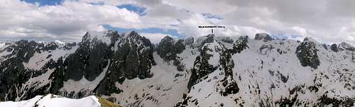 Prokletije panorama with Maja Vukoces (2450 m)
You're in border country and will have to ask for military permits to visit certain (Albanian) parts of the range, where is placed Maja Vukoces (2450 m) peak. At hotels and in a police station you can get information about the permits required. But there always destinations that are reachable without any permits.