
-
 21908 Hits
-
 84.82% Score
-
 19 Votes
|
|
Mountain/Rock |
|---|---|
|
|
39.19360°N / 106.112°W |
|
|
Park County |
|
|
Hiking |
|
|
Spring, Summer, Fall, Winter |
|
|
12818 ft / 3907 m |
|
|
Overview
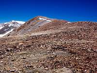 Nearing the summit of Sheep Mountain. on the Southeast Ridge.
Views from the summit of 12,818 ft. Sheep Mountain include (clockwise from the north):
- An up-close and personal look at Pennsylvania Mountain (13,006 ft.) to the north
- The Kenosha and Tarryall Mountains to the east-northeast
- South Park to the East
- East Buffalo Peak (13,300 ft.) and West Buffalo Peak (13,326 ft.) to the south
- Weston Peak (13,572 ft.) and Ptarmigan Peak (13,738 ft.) sit off to the southwest
- Horseshoe Mountain (13,898 ft.), Peerless Mountain (13,348 ft.) and Mount Sheridan (13,748 ft.) are to the west
- Mount Sherman (14,036 ft.) and Gemini Peak (13,951 ft.) rise to the northwest
Colorado Rank: 771st highest mountain in CO
Colorado 12ers Rank: 134th highest 12er in CO
Mountain Range: Tenmile-Mosquito
Prominence: Approximately 760 ft.
USGS Quad: Fairplay West
Trails Illustrated Map: #110
Getting There & Route Overview
| Route | Approximate Mileage | Approximate Elevation Gain | Seasonal Note | Driving Directions |
|---|---|---|---|---|
| Southeast Ridge | 8.5 miles roundtrip | 2,590 ft. | Southern exposure makes this a good option for the shoulder season | Hwy 285 to Rt 658 (north of Weston Pass Road). Follow signs to Browns Pass. |
| Fourmile Creek | 6.5 miles roundtrip | 2,200 ft. | Northern exposure makes this a good option for hot summer days | Hwy 285 to Rt 18 (Fourmile Road) to the Horseshoe Campground. |

Red Tape, Restrictions, Etc.
 Trio of ghost trees reaches for the sky on the southeast ridge.
07 June 08
Few formal restrictions apply to this area as it lies outside of federally-designated wilderness. Follow LNT (Leave No Trace) principals and be courteous of other recreationalists. The map suggests the existence of privately-owned mining claims on Sheep Mountain. The summit proper sits on public property. It is possible to summit this mountain without setting foot on a private mining claim. That being said, none of the private holdings are posted.
Camping & Lodging
 Just a few more feet to go to the summit of Sheep Mountain.
Route: Southeast Ridge.
07 June 08
 Gazing up a the false summit (foreground) and summit of Sheep Mountain. from approximately 12,000 ft. Only 800 feet to go!
07 June 08
Fourmile Creek Route
The US Forest Service operates two campsites along Fourmile Road: Horseshoe Campsite and Fourmile Campsite.
Southeast Ridge Route
Limited water is available on Browns Pass Road shortly after the ascent begins at about 10,500 ft. If camping above this point, plan on either hauling plenty of water or dry-camping.
Fairplay Hotels
Several hotels are available in the nearby town of Fairply, approximately 8 miles north of this area on Hwy 285.
Weather & Seasons
Sheep Mountain can be a year-round hike for those interested. The mileage of a winter outing greatly depends on how far west the approach roads are plowed. The Fourmile Creek route would likely be uninviting in snow season due to avalanche threat on the steep, ribbed slopes. The Southeast Ridge route could be used in snow season to gain the summit under the right conditions by an experienced party.External Links
Pike & San Isabel National ForestsSouth Park Ranger District campground Information
Pike National Forest Recreation Map
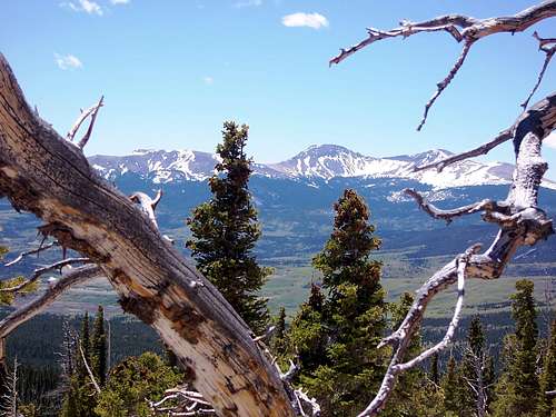 East Buffalo Peak (13,300 ft.) and West Buffalo Peak (13,326 ft.)
to the south through a ghost forest on the southeast ridge of Sheep Mountain.
07 June 08