
-
 7701 Hits
-
 81.84% Score
-
 14 Votes
|
|
Mountain/Rock |
|---|---|
|
|
44.60630°N / 108.8952°W |
|
|
Park |
|
|
Hiking, Scrambling |
|
|
Spring, Summer, Fall, Winter |
|
|
6442 ft / 1964 m |
|
|
Overview

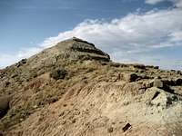
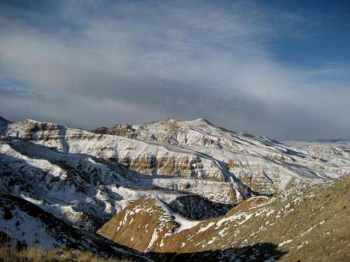
Peak 6442 is the striking, red, pyramid-shaped mountain seen looking east from Cody, WY in the McCullough Peak Badlands. When viewed from Cody, it looks like the highest mountain in range. Though it is shorter than the McCullough Peaks Highpoint by about 100 feet, it is a much more interesting climbing objective than its eastern neighbor. It is possible to climb this peak from both the north and south sides of the badlands; it could also be climbed via a rugged scramble of 2.5 miles between the two peaks. This page will detail the northern approach, as I haven't yet had the opportunity to explore the southern side. There is a summit register on top that shows just a handful of people that climbed this peak in 2008; from the top you have a fantastic view of over 100 miles of the Absaroka Range stretching from the Washakie Needles in the south to well into Montana.
Getting There
To approach Peak 6442 from the north, turn east onto Rd. 18 off of Highway 14 between Cody and Powell. The turn is approximately 3.5 miles southwest of the town of Ralston; after traveling less than a mile on Rd. 18, turn left on Lane 15 and follow it across the top of Corbett Dam and begin looking on the right for a red marker with the number 1647 on it. Turn right here and keep to the right, as there is a private drive with a residence to the left. This entire area is a huge maze of roads, so be sure to take a map along!

After turning off the pavement, travel for 0.3 mile and take the left fork; after another 0.3 mile there is a 4-way intersection, where you should continue going straight. Travel for 1.0 mile before turning right at the next fork - do not turn right at the large tires. After 0.7 mile, take a right, travel another 0.3 mile, and turn left. Keep going straight for 0.5 mile and turn right; it is here that the worst section of road presents itself as you go up the next hill. After making it up this section and traveling through the next flat section, you will have to decide if you want to hike or drive up the next very steep part of the road. I hiked the rest of the way from this point, and after another mile there is a sign closing the road to vehicle travel (ATV's are still allowed).
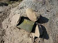
The hiking part of this trip involves staying on the road, which weaves its way through very wild country. You will see countless gullies and ravines scattered throughout the spectacular rock formations that make up the landscape. After two miles do not take the trail that heads off to the left, but keep going on the steep trails that keep heading up towards Peak 6442. Soon after this there is an intersection with signs marking several different paths; take the one that starts heading up and cuts back right around the mountain. This trail runs around the mountain about 200 feet below the summit, so at some point you will have to leave the trail and scramble up the last steep section to reach the top. Update Jan. 2, 2009: The metal box containing the summit register is missing - I searched around the immediate base of the summit pyramid, but was unable to locate it.

The total distance for this hike is between 1.5 and 2.5 miles of Class 1 trail one way, depending on where you park your car; this is followed by a short Class 2 scramble to the top.
Red Tape
There are no access fees to enter the McCullough Wilderness. The sign system marking access to roads was overhauled in 2004, and as a result, the roads are very clearly marked; there are more than 230 miles of roads marked with white arrows that are open to motorized travel, 20+ miles of roads open to ATV and non-motorized travel, 30 miles of administrative roads, and 60 miles of existing roads that are now permanently closed. Roads that enter this area from the south via Highway 14/16/20 are generally easy and don't require 4WD until you are several miles in, while the roads entering from the north from the Willwood District south of Powell need high clearance 4WD and very good judgment on the part of the driver to avoid getting into places where it is impossible to continue or turn around. The entire badlands area is prone to flash flooding which can quickly make travel impossible in places, so keep an eye on the canyon west of Cody to gauge the approach of any storms.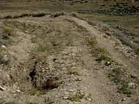 Road on the northern side of the badlands
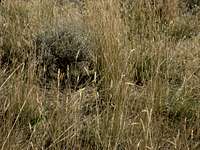 Rattlesnake in the sagebrush
All it takes is one look at this harsh rocky environment covered in sagebrush to know that this is prime rattlesnake country! They like to sunbathe on the rocks and curl up in the brush, so it is not uncommon to have close encounters with snakes that are on or next to the trail. Be extremely careful when hiking anywhere that is off of the road or trail because of the abundance of sagebrush; a slower pace will allow you to listen for the rattle, and will also give the snake a chance to leave as it senses your approach. Make sure you know how to look for them and how to act around these animals, in addition to knowing what to do if you are bitten by one (see link below).
Be sure to bring in enough water to drink, as suitable drinking water is not found in the badlands.
Camping
Camping is allowed in the McCullough Wilderness, with a maximum stay of 14 days in any 28-day period. For more information, visit the BLM camping rules page at:http://www.blm.gov/pgdata/etc/medialib/blm/wy/information/docs.Par.1775.File.dat/wynf-0019.pdf
External Links
Information on the McCullough wild horse herd:http://www.blm.gov/wy/st/en/field_offices/Cody/wh.html
http://www.friendsofalegacy.org/mustangs.htm
Horse Tour Information:
http://www.wildmustangtours.com/index.cfm
What to do in case of a Rattlesnake bite:
http://www.whmentors.org/saf/snakes.html