
-
 11966 Hits
-
 86.37% Score
-
 22 Votes
|
|
Mountain/Rock |
|---|---|
|
|
44.58290°N / 108.0857°W |
|
|
Big Horn |
|
|
Hiking, Scrambling |
|
|
Spring, Summer, Fall, Winter |
|
|
5010 ft / 1527 m |
|
|
Overview
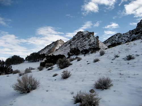
 Sheep Mountain South
The Sheep Mountain Anticline is situated between the towns of Lovell and Greybull in the northwest part of Wyoming; its long, narrow, and perfectly straight crest is an easily recognizable sight from many areas around the Big Horn Basin. An anticline is a geologic formation where the strata slope downward on either side of a crest, and this particular mountain is one of the more famous examples of this kind of formation. Running northwest to southeast for about 15 miles, the formation is dissected in the middle by the Big Horn River, which runs through the 1,000-foot deep Sheep Mountain Canyon (also known as the Black Canyon). There are three ranked summits along the ridge, one north of the canyon (Sheep Mountain North), and two south of it (Peak 4970 & Sheep Mountain South).
This page will cover both of the two southern peaks, as they are closely linked by a ridge and are easily done as a pair of summits. The large formations of rock spires on the east side of the anticline are really cool when viewed up close, and the summit views of the Big Horn Basin and its surrounding mountain ranges are very expansive for peaks with these relatively low elevations. A Native American vision quest structure can be found on the top of Peak 4970; while on top, it is interesting to imagine what it must have been like to spend the night facing east, followed by the beautiful spectacle of watching the sunrise creep slowly over the nearby Big Horn Mountains!
 Near the summit of Peak 4970
Getting There and Climbing Information
 Nearing the summit ridge
 Looking north along the ridge
Looking at a map, it looks like the logical way to reach the road to the east side of Sheep Mountain is from north of Greybull, Wyoming, but this road is closed to the public through the bentonite plant. The way to reach the right road is slightly convoluted, but it starts from the lone traffic light in downtown Greybull. Head east on Highway 14 across the bridge and turn left on Division street after 0.75 miles. Take Division to Hilltop and turn left before the road veers right, becoming Rimrock Road. Stay on Rimrock as it becomes a county road, finally reaching a "T" intersection with County Lane 33 after 2.3 miles. Turn right here, remembering to watch for fast-moving trucks on this road, as it is a busy haul road for the bentonite plant. Take the left fork (Crystal Creek Road) after 3.1 miles, and finally turn left another 1.8 miles past the fork. About 2.3 miles down this road, there is a 4WD road that branches off to the left; this is a good place to park if you're hiking these peaks in the winter, but during the warmer season, it will get you closer to the mountain.
 Peak 4970
 Summit Cairn
To reach the ridge, you will have to scramble between the large rock formations that stick out of the ground in a neat row all along the east side of the peak. There is some steep Class 2 scrambling to reach the very top of the ridge, where there are three points that just cross the 5,000-foot contour; the southern two are close by each other, and are separated from the northern one by a dip in the ridge. A monstrous cairn adorns the lone point, but it seemed to me like the one in the middle was the higher. Regardless, peakbaggers will want to visit all three spots before descending by the same route.
If you decide to climb Peak 4970 as well, continue north along the ridge to almost the end of the ridge and scramble off to the right down to the connecting saddle. Look for the long, obvious ridge that leads to the next mountain; follow easy game trails to the first of a couple false summits, where you can either scramble up over the rocks or go around. You will know when you're at the top by the half-oval of rocks, with the open end facing the Big Horns. This structure is not as well-preserved as some of the ones I've seen in the area, and I didn't notice it until I was taking pictures of the summit area. To descend, retrace your steps to the saddle and start looking for a way out from between the rock formation. The first gully is bad; it cliffs out, and if you descend too far, you may be unable to climb back up and out on the smooth sandstone! After a little tricky scrambling, I was able to get down and out of the second gully. Once you are back on flat ground, hike back across the dozens of creek beds, which can be pretty tiring if there is snow or the ground is muddy.
The total round trip distance for climbing both of these peaks is about 8.5 miles and 1500 feet of elevation gain on Class 2+ terrain.
 East side of the anticline
 Vision quest structure
Red Tape and Camping
Visit the BLM site for all rules and regulations regarding use of public lands. There are no fees involved with hiking in this area. Be sure to pay attention to signs posted detailing the active mining sites.As with all of the badlands areas in NW Wyoming, be very aware of approaching storms, as these areas are prone to flash-flooding, and even a little rain can quickly make these roads impassable. Rattlesnakes and mountain lions are found here, to take appropriate precautions to avoid these animals and know what to do if you encounter one.
For rules about camping on BLM land, visit this page.
 Summit view southwest
External Links
Information about the Sheep Mountain area:Sheep Mountain Anticline
Geology
Sheep Mountain South on Lists of John:
http://listsofjohn.com/PeakStats/Climbers.php?Id=11173
Peak 4970 on Lists of John:
http://listsofjohn.com/PeakStats/Climbers.php?Id=11189