
-
 13588 Hits
-
 93.81% Score
-
 44 Votes
|
|
Area/Range |
|---|---|
|
|
44.96933°N / 108.57513°W |
|
|
Hiking, Scrambling, Canyoneering |
|
|
Spring, Summer, Fall, Winter |
|
|
Overview
 The Big Horn Basin
A Basin is defined in the dictionary as "a hollow or depression in the earth's surface, wholly or partly surrounded by higher land." A page on a basin might seem out of place to some on a mountaineering website, but the Big Horn Basin in the northwestern part of Wyoming is home to over 100 ranked peaks that provide a wide range of hiking and scrambling destinations to anyone who is interested in obscure places. The climate here is very dry, and the area sees an average of only 6-10 inches of precipitation a year; this, combined with the fact that most of these mountains are under 6,000 feet, means that they are relatively free of snow during much of the winter.
The Big Horn Basin is about 100 miles wide, and is situated between the Absaroka Range to the west and the Big Horn Range to the east. It is bordered on the south by the Owl Creek and Bridger Mountains, while the northern end is open between the Beartooths and the Pryor Mountains. Two important rivers are located in the Basin; the Bighorn River runs south to north from the Wind River Canyon through the gap between the Owl Creek and Bridger Mountains (it changes from the Wind River to the Bighorn as it exits the northern end of the canyon), and the Shoshone river, which runs west to east and joins the Bighorn at Bighorn lake.
Note: The names "Big Horn" and "Bighorn" are used interchangeably in most cases; most maps show the river, range, national forest, canyon, and basin with the one-word title, while the county usually uses two words. However, I've found instances where all six things are spelled the opposite way, and the mountain range is more commonly known as the Big Horn Range. If anyone knows a concrete rule regarding the usages, please let me know. For the purposes of this page I've used "Big Horn" to describe the range and basin, while I've used Bighorn when referring to the river and canyon.
 In the Badland Hills
History
 John Colter
 Hole in the Wall Gang
In the 1870's, ranchers began bringing cattle and sheep to the area, and communities began springing up throughout the Basin. One early rancher, Otto Franc, started the Pitchfork Ranch near Meeteetse, which is still in operation today. Francs Peak, the highest in the Absaroka Range, is named after him; he accused Butch Cassidy, who lived near Meeteetse at the time, of stealing horses from him. Cassidy was convicted but was later pardoned by the Wyoming Governor and formed the Hole in the Wall Gang after his release. He and another famous outlaw, the Sundance Kid, operated from the Hole in the Wall cabin in the southern Big Horns. This cabin can now be found in the Old Trail Town in Cody.
 Buffalo Bill Cody
 Wild West Show poster
The most famous resident of the Big Horn Basin was the man who founded the town of Cody. William F. "Buffalo Bill" Cody was one of the most famous people in the world due to his wildly successful Wild West Show, which toured the planet from 1883 until 1913. He owned a ranch near Cody spent a lot of time in the town that he founded; he wanted to be buried on Cedar Mountain overlooking Cody, but the circumstances surrounding his death and burial prevented this from happening. See the Cedar Mountain page for more information on the story.
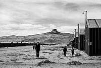 Heart Mountain Relocation Center
After Japan bombed Pearl Harbor during World War II, Japanese-Americans were rounded up and placed in camps throughout the United States. One of the ten internment camps was located between Cody and Powell near the eastern slopes of Heart Mountain. At its peak, the Heart Mountain Internment Camp was the third-largest city in Wyoming with a population of almost 11,000 people. In spite of the injustice that was being done to them and their families, many of the internees served in the U.S. army and fought and died for the country that had imprisoned them; an Honor Roll with the names of these soldiers and several original buildings still stand at the location of the camp. In 1988, President Reagan signed legislation that apologized for this terrible episode in the nation's history, and the government paid out $1.6 billion in restitution to all survivors of these camps.
The Big Horn Basin
 Bighorn Canyon
The Big Horn Basin is home to four counties (Park, Big Horn, Hot Springs, and Washakie) and twenty small communities, the largest of which is Cody with almost 9,000 people.
Cody is home to the world famous Buffalo Bill Historical Center, which is a complex of five museums known as the "Smithsonian of the West;" this, combined with the fact that the town is only 50 miles from the East Entrance to Yellowstone Park, makes it a huge tourist town during the summer months. It is the county seat of Park County.
Powell is a farming community of just over 5,000 people and is home to Northwest College, a two-year community college with about 2,000 students. Powell was voted an All-America city in 1994.
Worland also has about 5,000 people and is the county seat of Washakie County. It is one of the main bottling centers for Pepsi products, and is located near the southern end of the Big Horn Range.
Thermopolis is located in the southern part of the Basin just north of the Wind River Canyon. With a population of just over 3,000, it is home to the world's largest mineral hot springs and is the county seat of Hot Springs County.
Lovell is another farming town with a population of about 2,000. It is located near the northern part of the Big Horn Range and is also close to the Bighorn Canyon National Recreation Area. This place is one of the greatest treasures of the area, with a beautiful lake at the end of a deep and breathtaking gorge that runs for miles to the northern end of the Big Horn Mountains. View pictures of the canyon here.
 Shoshone Canyon and Buffalo Bill Dam
Other towns with less than 2,000 people in the Big Horn Basin include Basin (county seat of Big Horn County), Burlington, Byron, Cowley, Deaver, Frannie, Greybull, Hyattville, Manderson, Clark, Otto, Shell, Ralston, Ten Sleep, and Meeteetse.
When the Basin was being settled in the late 1800's, its dry climate made agriculture very difficult. Between 1905 and 1910, the Buffalo Bill Dam was constructed in the Shoshone Canyon, creating the Buffalo Bill Reservoir below Sheep Mountain on the eastern edge of the Absarokas where the North and South forks of the Shoshone River meet. A canal system was constructed that provided water for irrigation for farmland surrounding the cities of Cody, Powell, and Lovell, which is over 50 miles from the dam. Important crops grown in the area include sugar beets, pinto beans, barley, and alfalfa.
Much of the Big Horn Basin is rich in oil, and over 1.4 billion barrels have been extracted since the early 1900's. Uranium was mined in the northern part of the Basin.
The area has many dinosaur fossils sites, many of which can be seen at the Wyoming Dinosaur Center in Thermopolis. The Red Gulch Dinosaur Tracksite is located near Shell, Wyoming, and is managed by the BLM.
This region is home to three wild horse herds; the Pryor Mountain Herd is located near the Bighorn Canyon area, the McCullough Herd is found in the McCullough Badlands east of Cody, and the 15 Mile Herd is located in the badlands east of Meeteetse. All of these horses are under the management of the BLM.
Mountains of the Big Horn Basin
 Summit view from McCullough Peak. The peak in the foreground is Peak 6442 (McCullough Peak B); visible in the distance from left to right are Dead Indian Hill, Heart Mountain, and the eastern Beartooths
The peaks in the Big Horn Basin are rarely large or breathtakingly spectacular, but they do have a certain amount of charm because of their remote and often desolate feel; summit views revolve around panoramas of long sections of the surrounding ranges which tower 4,000 to 6,000 feet above the floor of the Basin. If you set out to hike these mountains, expect lots of sage brush, badlands formations galore, and rattlesnakes! Beauty can be found here in the hearty wildflowers and brightly colored dirt that abounds around these places.
Heart Mountain is the king of all peaks in the Big Horn Basin. Rising well over 2,000 feet above the surrounding terrain, this mountain is supposed to have slid to its current location from the edge of the Absaroka Range. At 8,123 feet, it is over 1,000 feet higher than any other mountains in the Basin.
This section will not include a list of all of the mountains in the area, but it will provide links to all of the peaks in Big Horn Basin that have pages on SummitPost. Additional information about specific areas can be found on the McCullough Badlands and Badger Basin pages.


Other Mountains
This section includes information about some mountains and unranked hills that are found in the Big Horn Basin that are very easy hikes (or drives) or are not prominent enough to have their own SummitPost pages. The descriptions only include basic route information, so it would be a good idea to study Google Earth and a topo map before driving to some of these places.| Name | Image | Description | Image | Lists of John Link |
|---|---|---|---|---|
| Peak 6730 |  |
Found just east of Meeteetse, Wyoming, this peak has some radio towers on it and is north of the highway. Park off of the highway and cross the pasture and another fence for a short scramble up the south side; there are two summits of similar height. There were no signs posted in October 2009, but this land is private property, so be respectful of it. |  |
Link |
| Buck Buttes |  |
This small butte-like formation offers wonderful views of the SE Absarokas. Follow the directions for driving to the Squaw Teats and look for the radio tower area about ten miles in on top of a plateau. The hike to the top takes all of five minutes; watch out for rattlesnakes. |  |
Link |
| Peak 6123 |  |
This gentle mountain is northwest of the town of Clark and has fine views of the eastern Beartooths. Take Road 1AB north of town as it heads around to the north side of the mountain. Look closely on the left for an opening between some fences with a very small sign for Wyoming Trust Land. This is the only way I could find to the peak without crossing private property, which is generally a really bad idea in this particular area. Park here and head south through the drainage or go right and bear left along the ridge to the twin summits, which are a just a couple of feet different in elevation. |  |
Link |
| Grass Benchmark |  |
This small but interesting sandstone formation is situated just behind the rest area on the highway about fifteen miles east of Meeteetse. I have no idea who owns this land, but I did not see any signs at the rest area in October 2009 discouraging exploration on this hill. Reaching the summit requires some route-finding; I went way left to scramble up past the first major band of sandstone before traversing all of the way across to the right side to walk up the easy slopes on the back of the peak. |  |
Link |
| Little Sheep Mountain |  |
This is the prominent peak just southeast of the town of Lovell; it has the white rock "L" on its northern slopes. Travel south from Lovell on the highway and turn left on Road 16.5. Stay on the main road until you can fork right and pass through a gate, which needs to stay closed behind you. Drive this easy 4WD road to the radio towers on top of the peak, which offers fine views of the surrounding area. |  |
Link |
| Sugarloaf Butte |  |
Follow Road 1AB north from Clark around the west slopes of this butte before turning right and driving on the dirt road to the north side. Walk south across unposted land to the top; a round trip can be completed in about 30 minutes. |  |
Link |
| Peak 4150 |  |
This small mountain overlooks the Bighorn River southeast and across the river from Little Sheep Mountain near Lovell. From Lovell, Wyoming, travel east on Highway 14A and turn left (south) on Crystal Creek Road, which is 3.1 miles after you cross the bridge over Bighorn Lake. The peak is off to the right as you travel along this road; look for a 4WD road that turns right and travels up the gentle slopes to the top. |  |
Link |
| Peak 3990 |  |
One of only three ranked peaks in the state under 4,000 feet, this hill is located in the Bighorn Canyon National Recreation Area. Take the first paved road to the right after the toll area, which heads to lake and a docking area. There is an RV camping area off to the left, which is where the Mouth of the Canyon Trail begins. Follow this trail for less than a mile to the highest point in the area, which is the summit. Amazing views of the river are found by continuing past the summit down to the cliff's edge. |  |
Link |
External Links and Sources
Wikipedia article on the Big Horn BasinHeart Mountain Relocation Center
Wyoming Dinosaur Center
Wyoming Tales and Trails - Extensive Resource on Wyoming History
Lists of John Website