
-
 3277 Hits
-
 78.27% Score
-
 9 Votes
|
|
Mountain/Rock |
|---|---|
|
|
44.56130°N / 108.9116°W |
|
|
Park |
|
|
Hiking, Scrambling |
|
|
Spring, Summer, Fall, Winter |
|
|
5616 ft / 1712 m |
|
|
Overview
 Ridge on Peak 5616
Located in the McCullough Peak Badlands just east of Cody, Wyoming, Peak 5616 is situated to the south of Peak 6442 between Penney Gulch and Rough Gulch. Its long gentle slopes make for fairly easy climbing, and the views of the impressive mass of Peak 6442 are very nice; a good part of the Absaroka Range takes up most of the skyline to the west.
One of the best parts about this hike is seeing one of the best badlands formations in this whole area. Shaped like a pyramid and located just west of the peak, this spire rises almost 200 feet above the surrounding area and is well worth a look.
 Pyramid
Getting There
 Route near the base of the mountain
 Summit with Peak 6442 in the background
To reach Peak 5616, start by heading east from Cody on Highway 14/16/20. Start marking miles at the place where Highway 120 turns south towards Meeteetse and continue on Highway 14/16/20 for 4.7 miles. Turn left on McCullough Peaks Road and start heading into the badlands. Turn left after 3.6 miles and drive for 2.3 miles, staying left at the one fork; these roads are easily drivable and are regularly graded. There is a small and very rough road at this point that turns right and heads down into Penney Gulch; park here and hike down this road.
At the bottom of the valley, start climbing up the obvious ridge that heads northeast up the mountain. There are game trails that take you most of the way up to the top. Just before you reach the top, there is a fence that must be crossed in order to reach the summit; you can also follow the small road left down a little ways and around the end of the fence.
The distance for this hike is 1.0 mile and about 500 feet of elevation gain, all of which takes place over the last half mile.
 Summit view southwest
Red Tape
There are no access fees to enter the McCullough Wilderness. The sign system marking access to roads was overhauled in 2004, and as a result, the roads are very clearly marked; there are more than 230 miles of roads marked with white arrows that are open to motorized travel, 20+ miles of roads open to ATV and non-motorized travel, 30 miles of administrative roads, and 60 miles of existing roads that are now permanently closed. Roads that enter this area from the south via Highway 14/16/20 are generally easy and don't require 4WD until you are several miles in, while the roads entering from the north from the Willwood District south of Powell need high clearance 4WD and very good judgment on the part of the driver to avoid getting into places where it is impossible to continue or turn around. The entire badlands area is prone to flash flooding which can quickly make travel impossible in places, so keep an eye on the canyon west of Cody to gauge the approach of any storms.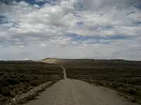 Road on southern side
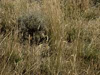 Rattlesnake in the sagebrush
All it takes is one look at this harsh rocky environment covered in sagebrush to know that this is prime rattlesnake country! They like to sunbathe on the rocks and curl up in the brush, so it is not uncommon to have close encounters with snakes that are on or next to the trail. Be extremely careful when hiking anywhere that is off of the road or trail because of the abundance of sagebrush; a slower pace will allow you to listen for the rattle, and will also give the snake a chance to leave as it senses your approach. Make sure you know how to look for them and how to act around these animals, in addition to knowing what to do if you are bitten by one (see link below).
Be sure to bring in enough water to drink, as suitable drinking water is not found in the badlands.
Camping
Camping is allowed in the McCullough Wilderness, with a maximum stay of 14 days in any 28-day period. For more information, visit the BLM camping rules page at:http://www.blm.gov/pgdata/etc/medialib/blm/wy/information/docs.Par.1775.File.dat/wynf-0019.pdf
External Links
Information on the McCullough wild horse herd:http://www.blm.gov/wy/st/en/field_offices/Cody/wh.html
http://www.friendsofalegacy.org/mustangs.htm
Horse Tour Information:
http://www.wildmustangtours.com/index.cfm
What to do in case of a Rattlesnake bite:
http://www.whmentors.org/saf/snakes.html