
-
 3046 Hits
-
 81.18% Score
-
 13 Votes
|
|
Mountain/Rock |
|---|---|
|
|
44.64230°N / 108.7198°W |
|
|
Park |
|
|
Hiking, Scrambling |
|
|
Spring, Summer, Fall, Winter |
|
|
4890 ft / 1490 m |
|
|
Overview

Peak 4890 stands alone in the northeast corner of the McCullough Peak Badlands south of Powell, Wyoming. It feels higher than it actually is due its relative isolation; from its summit you can look out over the wide expanse of sage-covered plains and hills that are roamed by the wild horse herd that lives in this area. It also offers good distance views of the rest of the McCullough Peaks to the south, as well as the Beartooth, Pryor, and Big Horn mountain ranges.
The hiking and scrambling found on and around this mountain offer a good introduction to peak bagging in this area; the ridges leading up to the top are gentle and lack (for the most part) the dangerous hard ground covered in pebbles that is found on many of the other mountains around here. Wildlife, especially deer, is abundant in this area, and it hard to hike far without finding a good game trail.
Getting There
To get to this mountain, start at the light in downtown Powell at the Subway restaurant. Travel south on Highway 295 for 8.0 miles, rounding left around the corner in Willwood. Turn right on Road 5, which passes left around a small airstrip and goes around to the back of the small hill which is directly ahead of the road. There is an intersection here, at which point you want to get on the long straight road that heads southwest. This is a pretty good road and does not require high clearance or 4WD unless it gets driven on and rutted out after heavy rainstorm. After 3.0 miles you will arrive at the brown BLM sign that provides some information about the area, mountain lion warnings, and a map. After this point, driving becomes more difficult as creeks appear with more frequency, so it might be a good idea to park here and hike from this point. Game trail up the ridge
 Summit view west
Peak 4890 is due south from here, and the walk to it is on the road for about a half mile. After this, leave the road and walk for about 0.75 mile towards the ridges on the left side of the mountain and look for one of several game trails that will take you up one of the ridges. Keep an eye out for rattlesnakes in the brush or on the rocks! Once on top of the ridge, head left towards the summit, which has a short and steep Class 2 section right before the top.
One way, this hike totals 1.5 miles and 500 feet of elevation gain.
 Just before the summit
Red Tape
There are no access fees to enter the McCullough Wilderness. The sign system marking access to roads was overhauled in 2004, and as a result, the roads are very clearly marked; there are more than 230 miles of roads marked with white arrows that are open to motorized travel, 20+ miles of roads open to ATV and non-motorized travel, 30 miles of administrative roads, and 60 miles of existing roads that are now permanently closed. Roads that enter this area from the south via Highway 14/16/20 are generally easy and don't require 4WD until you are several miles in, while the roads entering from the north from the Willwood District south of Powell need high clearance 4WD and very good judgment on the part of the driver to avoid getting into places where it is impossible to continue or turn around. The entire badlands area is prone to flash flooding which can quickly make travel impossible in places, so keep an eye on the canyon west of Cody to gauge the approach of any storms.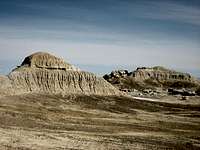 Badlands hills
 Beetle
All it takes is one look at this harsh rocky environment covered in sagebrush to know that this is prime rattlesnake country! They like to sunbathe on the rocks and curl up in the brush, so it is not uncommon to have close encounters with snakes that are on or next to the trail. Be extremely careful when hiking anywhere that is off of the road or trail because of the abundance of sagebrush; a slower pace will allow you to listen for the rattle, and will also give the snake a chance to leave as it senses your approach. Make sure you know how to look for them and how to act around these animals, in addition to knowing what to do if you are bitten by one (see link below).
Be sure to bring in enough water to drink, as suitable drinking water is not found in the badlands.
Camping
Camping is allowed in the McCullough Wilderness, with a maximum stay of 14 days in any 28-day period. For more information, visit the BLM camping rules page at:http://www.blm.gov/pgdata/etc/medialib/blm/wy/information/docs.Par.1775.File.dat/wynf-0019.pdf
 Small lake in the McCullough badlands
External Links
Information on the McCullough wild horse herd:http://www.blm.gov/wy/st/en/field_offices/Cody/wh.html
http://www.friendsofalegacy.org/mustangs.htm
Horse Tour Information:
http://www.wildmustangtours.com/index.cfm
What to do in case of a Rattlesnake bite:
http://www.whmentors.org/saf/snakes.html