
|
|
Mountain/Rock |
|---|---|
|
|
50.08623°N / 17.23137°E |
|
|
Hiking, Skiing |
|
|
Spring, Summer, Fall, Winter |
|
|
4892 ft / 1491 m |
|
|
Overview
Praděd /pol. Pradziad, ger. Altvater, engl. Great Grandfather/- 1491 m- the mighty king of the Jeseniky. The highest peak of the Eastern Sudetes, Morava and Upper Silesia. The fifth highest mountain in the Sudetes and the Czech Republic, but the highest outside Krkonose. The Czech ‘big five’:- Snezka: 1602 m
- Studnicni Hora: 1554 m
- Lucni Hora: 1547 m
- Vysoke Kolo: 1509 m
- Praděd: 1491 m
 Praděd
Praděd is located in the center of the highest part of the Jeseniky- Hruby Jesenik in its main ridge.
Ridges that branch off on Praděd:
- North- main: to Maly Děd /1354 m/ and further to Cervenohorske Sedlo /1020 m/- the pass that separates Praděd Massif and Serak- Keprnik Massif
- South- main: to Vysoka Hole /1463 m/ and Kamzicnik /1419 m/
- West: to Velky Děd /1379 m/
- East: to Prostredni Vrch /1139 m/
- North- East: to Sokol /1186 m/
Praděd is notorious for cold climate. The annual average temperature is +1 degree Celsius. The extremely strong winds make the summit of Praděd even a colder place.
The top of Praděd rises over the forest line and that makes the mountain a fantastic view point. In clear days you may see theSudetes, the Tatras and even an Austrian part of the Alps.
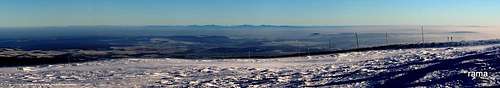 Panorama from the summit
The highest parts of Praded is natural reserve established in 1991 after connecting 6 smaller reserves:
- Petrovy kameny
- Velká kotlina
- Malá kotlina
- Vrchol Pradědu
- Divoký Důl
- Bila Opava
The protected area is over 2000 ha.
Info in English about the reserve.
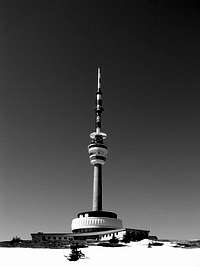
The tower
 The tower
The tower on Praděd is really characteristic. The main architect, Jan Liska created a project of concrete tower that is similar to a taking off space-rocket. The works started in 1968 and during next the 9 years an asphalt road was constructed. The tower was built between 1977 and 1983 and it’s 162 meters high. The top of the tower is the highest /although not natural/ point in Sudetes and Czech Republic: 1491+ 162= 1653 m and exceeds the observatory on Snezka: 1602+18= 1620 m. Next to the tower there’s a mountain hotel with a restaurant and a meteorological observatory. The tower itself offers also an view terrace located 77 m above the ground.
 The old tower The old tower |
 The new tower The new tower |
 The new tower The new tower |
The old tower- Altvaterturm /later: Adolf Hitler Turm/ was built in 1903. The tower was 32 meters high and created by an architect Franz Ritter von Neumann. The tower built in the Neoghotic style wasn’t capable of withstanding severe weather conditions so it had to be permanently repaired. During the Second World War there was a Wehrmacht meteorological observatory on the summit. After the war the tower was closed and finally it collapsed in 1959.
Routes
The shortest route is from parking lot next to Ovcarna pod Pradědem. The parking lot is accessible by several marked paths from all sides of the mountain or by bus from Parking lot Hvezda near Karlova Studanka /you have to leave your car here/. From Ovcarna take the red marked path to a crossroad called Pod Pradědem /1420 m/. There starts the final part and the only possibility to reach the summit of Praděd: blue marked path /30 minutes/.For other routes in the area of Praděd see the map below:
 The map
Getting there
The nearest airport is in Mosnov.The main cities in the nearby area are: Sumperk, Bruntal and Jesenik. Good bus and train. A little smaller but located closer to Praded cities are Vrbno pod Pradedem and Rymarov, also accessible by train.
Starting point for buses to Ovcarna pod Pradědem is Karlova Studanka /parking lot Hvezda/, located just north of Mala Moravka.
Online map of the area
 Praděd in the distance
Accommodation/ camping
 Ovcarna
There are three mountain huts located on Praděd:
- Ovcarna: 1300 m, accessible by asphalt road or by bus. Official site.
- Svycarnia: 1315 m, north from the summit. Official site.
- Barborka: 1320 m, just south from the summit of Praded. Official site.
Accommodation: nasehory.cz
Accommodation: jeseniky.net
Camping is not allowed.
Cycling and skiing
 Summer
Cycling
For detailed info about cycling in Praděd area see mbpost page: Praděd on mbpost
 Winter
Skiing
Centrum Figura- Praděd:
6 ski lifts and 7 ski trails. 4 easy /up to 800 m long/, 2 moderate and 1 difficult.
Info, map, webcam.
Centrum Mala Moravka
17 ski lifts, 11 ski trails.
Info, map, webcam.
Cervenohorske sedlo
8 ski lifts, 10 ski trails.
>Info, map, webcam.
Red tape
 Ski area
Because the area is a natural reserve hiking is possible only using marked paths. There’s a possibilty of driving a car to Ovcarna but it must be annouced in the office:
 Praděd
Správa CHKO Jeseníky
Šumperská 93
790 01 Jeseník
Tel.: +420 584 458 659
Fax: +420 584 458 646
E-mail: jeseniky@nature.cz
Emergency
Stanice HS Ovčárna,79324 Karlova Studánka 273,
tel: 554 799 020
Emergency numer: 602 666 603
Horska Sluzba(Jeseniky) official site
Horska Sluzba (main) official site
When to climb
WeatherWeather forecast for Praděd
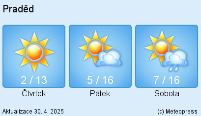
Weather forecast for Jeseniky
Webcams
Essential gear:
Best time for hiking is summer season: June-September. In summer no special equipment is needed.
In winter conditions: casual equipment for hiking in winter. Expect a lot of snow.