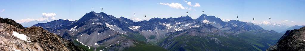
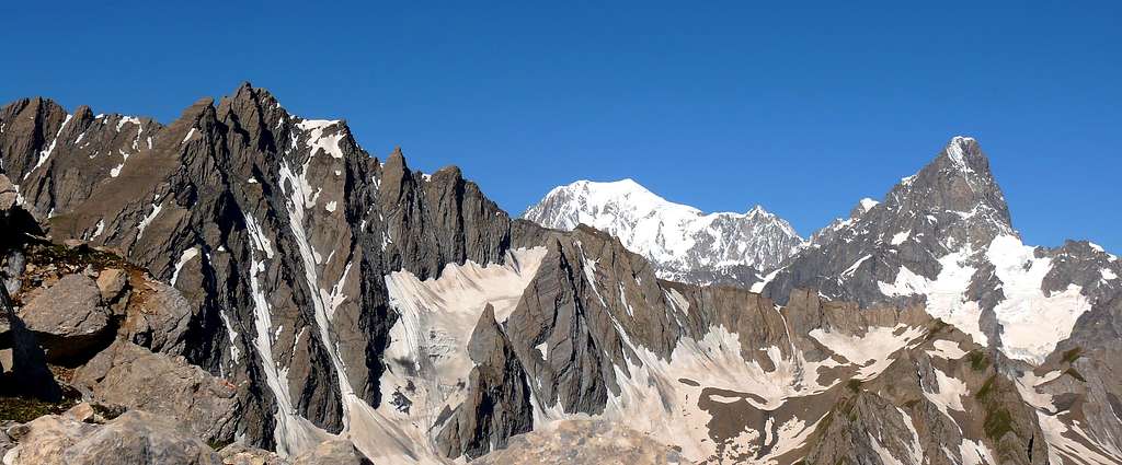
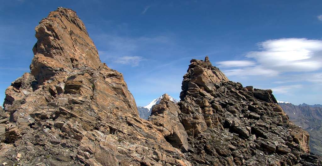
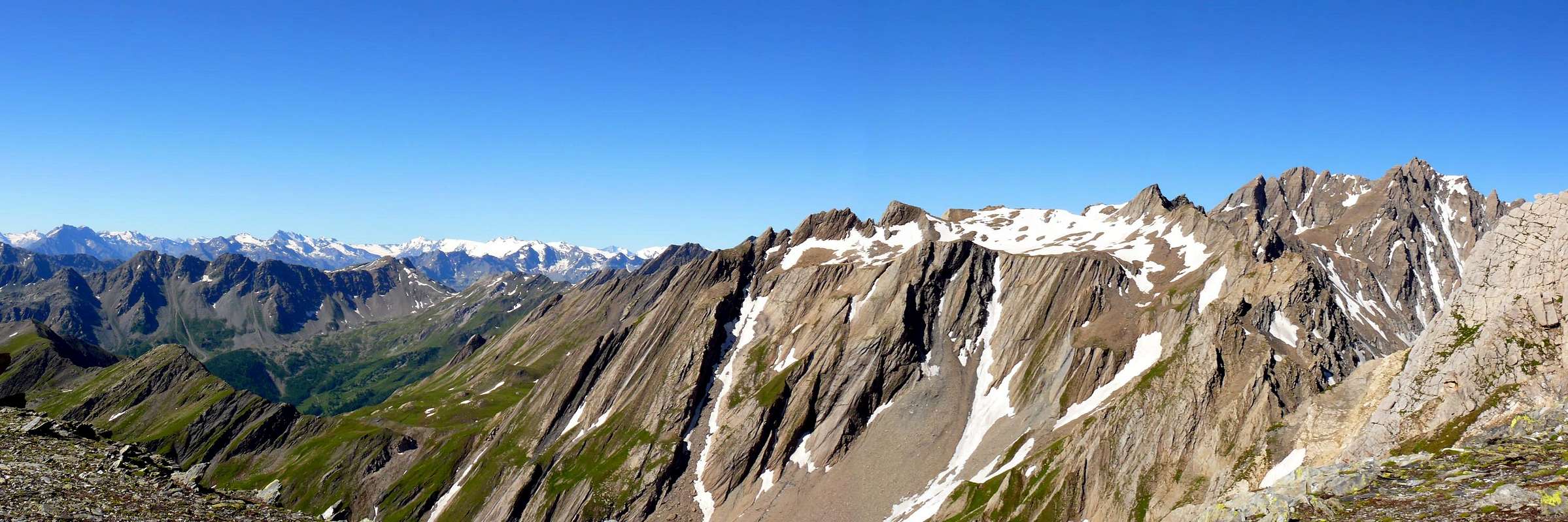
Huge bulwark made by two summits justified S-N: the Piccolo (3.234m) and the Grand Golliaz or Golliat (goille = water spring); the most important summit of the range between Mont Blanc and Velan-Combin Groups on the border ridge between Italy and Switzerland. Magnificent panoramic tower in the NW side of Val d'Aosta with a great round view even on Swiss giants. The bad quality rock doesn't allow fine climbing routes, the icy routes (N wall) are interesting but dangerous for the continuous rock falls in the channels. The SE side, ski-mountaneering route, requires well tidy snow. From the topographical point of view it has three ridges and as many slopes, while, if one considers it as one with the Petit Golliaz, it assumes, at least when viewed from the East, the shape of a large armchair with the tiny Glacier des Bosses. The two border crests (North-Northwest and East) are more beautiful to see from an aesthetic point of view than to climb, as the rock is made up of dangerous calcescists (as well as for the walls) that are easily disintegrated and such as to form a constant danger of falling stones on the slopes (especially on the steep North Face). The third, or South-southwest Arête, has little of this term, appearing, when seen in conjunction with the opposite crest from Petit Golliaz, as a broad crescent-shaped summit saddle, before heading decisively to the East towards the peak of the Vetta, characterized by a large stone cairn. Below the convexity of this saddle descend the two Western slopes of the Grand and the Petit Golliaz, separated by a small gully that starts at the Western ante Summit of the first (3.225/30 meters approximately); the same precipitate for over 350 meters above the Bellecombe little Valley in the Italian Ferret Valley (Arnuva locality). Observed from this side, not considerend the three meters difference in height, the toponyms should be reversed, because the mass of the Petit dominates that of the Grand Golliaz. In fact, while the Grand has an oblong triangular wall formed at the top by a small irregularly trapezoidal rocky band, the West Side of the Petit Golliaz (3.234m) is formed by two robust rocky ribs in the middle of which it wedges a much larger gully-couloir, often snowy. There remains the North Wall which, with its bizarrely Gothic architecture, if it were not for the poor quality of the rock, could compete with the great walls of the Mont Blanc Chain. It, formed by a series of obliquely laid out pillars to the right (West), as well as alternating with horrid gullies, projects for almost 500 meters above the underlying Glacier des Angroniettes.. HISTORICAL NOTES: North Face, as attractive as it is more than difficult, dangerous because it is considerably exposed to falling stones, it has been revisited, after the first routes between 1892, 1898 and 1905, between the end of the Nineties and the beginning of the new Millennium. Also for the historical part, note the first winter ascent in February 1917 by Aldo Bonacossa with Mountain Guide Alexis Brocherel , two famous names in classic mountaineering of the early 1900s. As for the other two sides (East/West) little to report, if not some "explorations" on both the Grand-Petit Golliaz. With regard to ski mountaineering, it is generally limited to the Eastern great shoulder of the East Crest starting, both on the Italian and Swiss side, from Col des Angroniettes (2.974 m), but, as far as known, with very rare climbs.
Potente bastionata composta da due cime allineate sull'asse S/N: il Piccolo (3.234 m) e il Grand Golliaz o Golliat (da goille, ovvero sorgente d'acqua); prima e unica grande cima tra la Catena del Monte Bianco e il Gruppo Vélan-Combin, sulla cresta di confine italo-elvetica. Magnifica torre panoramica posta a NW della Valle d'Aosta con splendida vista a 360°, anche sui colossi franco-svizzeri. La cattiva qualità della roccia non permette grandi itinerari di arrampicata; le vie glaciali (parete N) sono tecnicamente interessanti, ma pericolose per le continue scariche di pietre nei canali. Il versante SE sci-alpinistico richiede neve trasformata e ben assestata. Dal punto di vista topografico si presenta con tre creste ed altrettanti versanti, mentre, se lo si considera come un tutt'uno con il Petit Golliaz, assume, almeno se visto da Oriente, la forma di una grande poltrona con ai suoi piedi il minuscolo Glacier des Bosses. Le due creste di confine (Nord-nordovest ed Est) risultano più belle da vedersi sotto il profilo estetico che non da scalarsi, essendo la roccia formata da pericolosi calcescisti (come daltronde anche per le pareti) facilmente disgregabili e tali da formare un costante pericolo di caduta di pietre sui versanti (soprattutto sulla ripida Parete Nord). La terza, o Sud-sudovest Arête, poco ha di questo termine, apparendo, se vista in connubio con l'opposta cresta proveniente dal Petit Golliaz, quale ampia sella sommitale dall'aspetto a mezzaluna, prima di dirigersi decisamente ad Oriente verso la cuspide della Vetta, caratterizzata da grande ometto in pietra. Al di sotto della convessità di questa sella scendono i due Versanti Occidentali del Grand e del Petit Golliaz, separati da un piccolo canalone che prende l'avvio presso l'antecima Ovest del primo (3.225/30 metri circa); i medesimi precipitano per oltre 350 metri sopra il Vallone di Bellecombe in Val Ferret italiana (in località d'Arnuva). Osservate da questo lato, al di là dei tre metri di differenza in altezza, si dovrebbero invertire i toponimi, perché la massa del Petit sovrasta quella del Grand Golliaz. Infatti, mentre il Grand presenta un'oblunga parete triangolare formata al sommo da una piccola fascia rocciosa irregolarmente trapezoidale, il Versante Ovest del Petit Golliaz (3.234 m) è formato da due robusti costoloni rocciosi in mezzo ai quali si incunea un canalone di dimensioni ben più grandi, nonché spesso innevato. Rimane la Parete Nord che, dall'archittettura bizzarramente gotica, se non fosse per la cattiva qualità della roccia, potrebbe fare concorrenza alle grandi pareti della Catena del Monte Bianco. Essa, formata da una serie di pilastri obliquamente adagiati verso destra (Ovest), nonché alternati ad orridi canaloni, si proietta per quasi 500 metri al di sopra del sottostante Glacier des Angroniettes. NOTE STORICHE: la Nord, tanto attraente quanto, più che difficile, pericolosa perché esposta notevolmente alla caduta di pietre, é stata rivisitata, dopo i primi percorsi tra il 1892, 1898 e 1905, tra la fine degli Anni Novanta e l'inizio del nuovo Millennio. Sempre per la parte storica, da annotare la prima salita invernale nel febbraio del 1917 da parte di Aldo Bonacossa con la Guida Alexis Brocherel, due nomi celebri dell'alpinismo classico d'inizio '900. Per quanto concerne gli altri due versanti (Est ed Ovest) poco da segnalare, se non alcune "esplorazioni" sia sul Grand che sul Petit Golliaz. Riguardo allo sci-alpinismo, ci si limita, in genere allo spallone Orientale della Cresta Est con partenza, sia sul lato italiano che su quello svizzero dal Col des Angroniettes (2.974 m), ma con, per quanto é dato a conoscersi, ben rare salite.
First Ascents
Grand Golliaz:
First in the summit: Ten. Cornaglia of I.G.M., (1879).
In winter: A. Bonacossa and A. Brocherel, (Feb, 1917).
SE Slope: Ten. Cornaglia of I.G.M., (1879).
E-SE Wall (Direct Route from Glacier des Bosses): Osvaldo Cardellina and Alessandro Cardellina, (Sep 07th, 2011).
S-SW Arête: Unknown.
W Slope: Mario Gabinio and Luigi Galeani, (Jul 16th, 1896), in descent.
W Wall: Osvaldo Cardellina, (Sep 19th, 1993).
W Slope and N-NW Arête: Adolfo Hess and Laurent Croux, (Jul 15th, 1898).
N-NW Arête: Alessio Alvazzi and David Quaizier, (Jun, 1918).
N Wall and NW Arête (right couloir): Abbé Joseph Henry, (Aug, 1892), in descent.
N Wall and NW Arête (right couloir): Alfred George Topham, Jean Maître and Pierre Maurys, (Jul 06th, 1898), in ascent. First repetition? Osvaldo Cardellina, lone, (Jun 26th, 2010).
N Wall and E Arête: Marcel Kurz and Eberhard Phildius, (Aug 19th, 1905).First repetition? Osvaldo Cardellina and Alessandro Cardellina, (Jun 17th, 2010).
N Wall and E Arête (left couloir): Osvaldo Cardellina, lone, (Aug 30th, 1997).
E Arête: Alfred George Topham, Jean Maître and Pierre Maurys, (Jul 06th, 1898), in descent.
Petit Golliaz:
First on Summit: unknown.
First ascent in winter: unknown.
Southern Wall: Gino Buscaini and Silvia Metzeltin; July 14th, 1970, in descent by Southwest Crest into the more Western Couloir towards Bellecombe Pass. In ascent: Osvaldo Cardellina and Giuseppe Lamazzi; August 04th, 1996, in ascent and in descent through the Southwest Crest.
Southwest Crest (Normal Route from Val Ferret): Unknown.
Western Crest: Osvaldo Cardellina, lone; June 20th, 1996, in ascent and traverse to Grand Golliaz, climbed along the Southwestern Ridge with descent through North-northwest Ridge up to the Altitude 3.082 meter and descent on West-northwest Edge of the same to Bellecombe Valley-Arnouva .
Western Face: Osvaldo Cardellina, lone; September 19th, 1993, in descent after the traverse from Grand Golliaz, climbed through Western Wall.
Northern Crest (standard Route by Gran St. Bernardo): Martino Baretti and Augusto Sibille; August 12th, 1881, in descent.
Northeast Slope: unknown.
East-northeast Face between the Top and Northern Antesummit (Couloir of Right): Osvaldo Cardellina, Marco Cossard and Giuseppe Lamazzi; August 01th, 1982, in ascent with traverse to Grand Golliaz by Southwestern Ridge, in ascent and in descent.
Getting There
BY CAR:
From Torino, Milano, etc: Motorway A5. Exit Aosta Est.
From Switzerland: through the Grand St. Bernard Tunnel or the homonym pass.
From France: through Mont Blanc Tunnel or Petit St. Bernard Pass. It isn't necessary to enter in Motorway A5, you can drive through SS.26 Aosta direction.
BY PLANE:
Aeroporto "Corrado Gex" Saint Christophe (Aosta).
Route
From Mottes (1.670m - Hamlet of Bosses, reachable from the route SS.27 of Gran San Bernardo) toward W, descending a little to pass under the highway near the "big bend". Cross the Artanavaz Stream on a small bridge the on to the Pastures of By (1.767m), Potz-Ardusi (1.784m) and Moindaz (1.973m), bordering the waterfalls of Thoules stream. You can arrive here also starting from the Devies car parking, just beyond the "big bend", through the Pastures of Merdeux Desot (1.919m) and Côtes (1.930m). From Moindaz cross twice the stream and follow the Eastern bank till the Pastures of Comba Toula and near the Saint Rhémy Pass; follow the path coming from it and, passing some dry channels toward West, up toward the moraine of the small Glacier des Bosses. Get it at about 2.700m, leaving on the left the path to Col de Sauliè. On along the moraine (steep and tiring) to get the remains of the glacier; after a short and steep (35/38°) slope face the rocky bar in the middle, starting from left, then to the right along a system of ledges with some tracks (I° e II°, ice or water on the rock). Once at the upper debris/snow band, toward NW to a narrow very steep channel of about 100m (rocks and debris) on the SSE side getting the big cairn on the summit (5h'00). Variant: in the lower part you can get the high Comba Toula from the hairpin bend 2.079m of the road SS.27 beyond the Praz d'Arc Pasture along the military road of Colle di Saint Rhèmy (2.540m).
Descent: Retracing the route.
Da Mottes (1.670 m, Frazione di Bosses, raggiungibile dalla Strada Statale n°27 del Gran San Bernardo) indirizzarsi ad O scendendo leggermente a sottopassare l'autostrada alla "grande curva". Superato il Rio Artanavaz su un ponticello, si raggiungono in progressione le Alpi di By (1.767 m), Potz-Ardusi (1.784 m) e Moindaz o Muenda (1.973 m), dopo aver fiancheggiato le cascate del Torrent de Thoules. Qui giunge anche il sentiero dell'Alta Via n° 1 che parte dal parcheggio di Devies, appena oltre la "grande curva", per le Alpi Merdeux Desot (1.919 m) e Côtes (1.930 m). Dall'Alpe Moindaz attraversare il torrente due volte proseguendo senza percorso obbligato sulla sponda E e portarsi sui pascoli della Comba Tula sino nei pressi del Colle di St. endoRhémy; seguire il sentiero proveniente dallo stesso e con direzione W, superati alcuni solchi torrentizi asciutti, puntare alla morena frontale del minuscolo Glacier des Bosses. Raggiungerla a quota 2.700 m~, dopo aver lasciato a SW il sentiero per il Col de Sauliè. Risalirla con percorso ripido e faticoso e raggiungere i miseri resti del ghiacciaio; dopo breve e ripido scivolo (35/38°) affrontare la fascia rocciosa nel mezzo dapprima a sinistra, poi a destra su una serie di cenge con alcune tracce (I° e II°, verglass o acqua sulla roccia). Raggiunta la falda detritico-nevosa superiore puntare a NW verso un canalino di rocce rotte e detriti di 100 m~ piutosto ripidi sul versante S-SE raggiungendo il grosso ometto di vetta (5h'00). Variante: Si può accedere all'alta Comba Toula dal tornante 2.079 m della SS.27 oltre l'Alpe Praz d'Arc per la strada militare del Colle di Saint Rhèmy (2.540 m).
Discesa: Lungo la via di salita.
Difficulty
The route can be classified as PD or PD+.
L'itinerario è classificato da PD (Poco Difficile) a PD+ (Poco Difficile+).
Gear
Rope, iceaxe, crampons and helmet.
Corda, piccozza, ramponi e casco.
Campings
Remember that free camping is forbidden (except for emergency reasons, over 2.500m, from darkness until dawn).
Climbing Shots
Mountain Conditions
You can get meteo information at the official site of the Regione Valle d'Aosta:
A.I.NE.VA. (Associazione Interregionale Neve e Valanghe).
Useful numbers
Protezione Civile Valdostana località Aeroporto n° 7/A Saint Christophe (Ao) Tel. 0165-238222.
Bollettino Meteo (weather info) Tel. 0165-44113.
Unità Operativa di Soccorso Sanitario Tel. 118.
Acknowledgements
I am greatly indebted to my friend "Osva" for the detailed description of the route. In addition i want to thank Gabriele Roth for the translation of the text from italian.
Parents refers to a larger category under which an object falls. For example, theAconcagua mountain page has the 'Aconcagua Group' and the 'Seven Summits' asparents and is a parent itself to many routes, photos, and Trip Reports.

 16357 Hits
 92.85% Score
 40 Votes