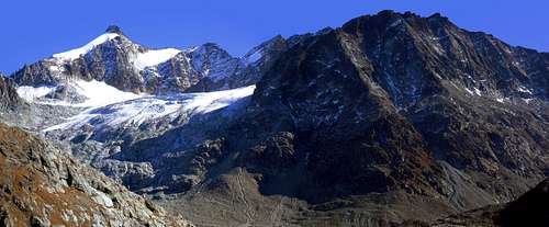
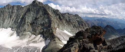
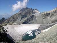
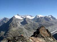
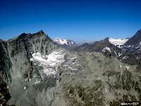
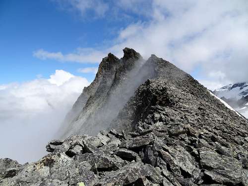
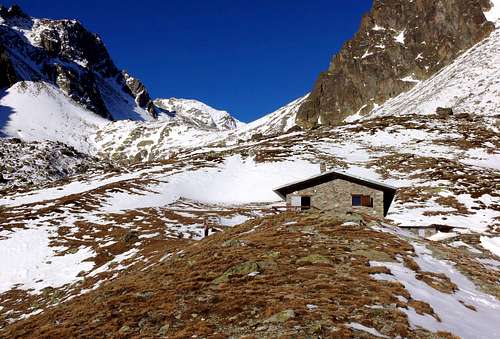
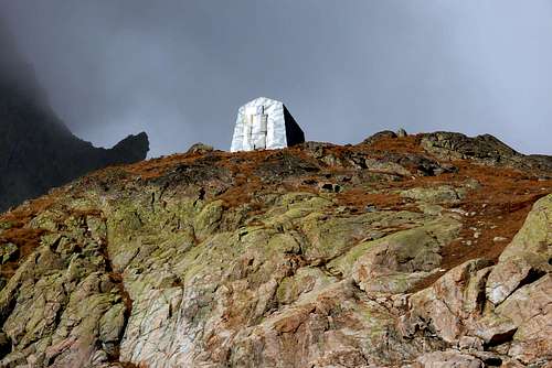
The Trouma des Boucs raises on the border between the Valle d'Aosta (Italy) and the Switzerland. The mountain is climbed in winter by ski and in summer. The rocky environment of this trekking is really wild and offers an inusual panorama on some Switzerland mountains as the south east face of the Grand Combin, the massif of Mont Blanc de Cheillon and the big Glacier d'Otemma. On the Italian side, more than the far Gran Paradiso, the view includes the severe walls of the Morion Group and the Mont Gelé. The easy ridge of the Dents d'Oyace and the high part of the way for the Trouma des Boucs is appreciated by people loving a little of adventure because there is no path and the course from the Col of Crête Sèche to the Col of Chardonney is not fixed. The use of the ancient Bivacco Spataro in place of the Rifugio Crête Sèche add some more adventure and an old alpinism atmosphere. Of course in this case it's necessary to carry his own food or to buy it in the Rifugio. Starting from the Bivacco Spataro or the Rifugio Crête Sèche it's possible to climb more difficult summits as the Mont Gelé (harness, crampons, axe and rope), or some interesting rock walls as the Vierge de l'Arolletta (IV), the Morion (IV;V), the Becca di Chardonney (IV).
La Trouma des Boucs si pone al confine tra la Valle d'Aosta (Italia) e la Svizzera. La montagna viene salita in inverno con gli sci e in estate. L'ambiente roccioso di questo trekking è davvero selvaggio ed offre un panorama inusuale su alcune montagne in Svizzera, come la Parete Sudest del Grand Combin, il Massiccio del Mont Blanc de Cheillon e sul grande Ghiacciaio d'Otemma. Da parte italiana, oltre all'estremo Gran Paradiso, la vista include le severe pareti dei Gruppi del Morion e Mont Gelé. La facile cresta del Dents d'Oyace e la parte alta della via per la Trouma des Boucs è apprezzata da chi ama un po' d'avventura, perché non vi è alcun percorso ed il tratto dal Col di Crête Sèche al Col di Chardonney non é prefissato. L'uso dell'antico Bivacco Spataro al posto del Rifugio Crête Sèche aggiunge un po' più d'avventura e una vecchia atmosfera dell'alpinismo. Naturalmente in questo caso è necessario portare il proprio cibo o comprarlo nel Rifugio. A partire dal Bivacco Spataro o dal Rifugio Crête Sèche è possibile scalare vette più difficili come il Mont Gelé (imbragatura, ramponi, piccozza e corda), o alcune pareti rocciose interessanti come la Vierge de l'Arolletta (IV), il Morion ( IV, V), la Becca di Chardonney (IV).
First Ascent
First on the summit: Unknown.
In winter: Unknown.
Getting There
BY CAR:
From Torino, Milano, etc: Motorway A5. Exit at Aosta Est.
From Switzerland: through the Grand Saint Bernard Tunnel or the namesake pass.
From France: through the Mont Blanc Tunnel or Petit Saint Bernard Pass. It is not necessary to take Motorway A5: you can drive on SS.26, in the direction of Aosta.
BY PLANE:
Aeroporto "Corrado Gex" Saint Christophe (Aosta).
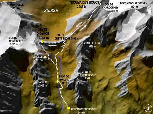
WGS84 UTM Zone 32T Rifugio Crête Sèche 375.849 E 5.082.405 N Col de Crête Sèche 375.291 E 5.084.358 N Bivacco Spataro 375.368 E 5.083.032 N Trouma des Boucs 376.146 E 5.085.727 N Dents d'Oyace 374.609 E 5.084.009N
Itinerary
From highway toll of Aosta Est follow the SS.27 of Gran San Bernardo Tunnel, drive for about ten km and turn, to the right, toward Valpelline (964m), pass through it and follow for Oyace (1.377m). Once in Dzovenno (1.575m), turn to the left toward the small Village of Ruz (1.697m), park the car and start walking along a comfortable dirt road leading to the Baou de Bouque (2.129m) and to the Berrier Pastures (2.192m)1h'30.
Dall'uscita del Casello Autostradale di Aosta Est, proseguire sulla SS.27 in direzione del Tunnel del Gran San Bernardo; dopo circa un decina di chilometri svoltare sulla destra verso il Paese di Valpelline (964 m). Dopo averlo superato ed aver ignorato il bivio sulla sinistra che conduce a Ollomont (1.335 m) proseguire verso l'abitato di Oyace (1.377 m). Raggiunta la Frazione di Dzovenno (1.575 m), svoltare a sinistra verso il piccolo Villaggio di Ruz (1.697 m); qui posteggiare l'auto e iniziare la salita a piedi lungo la comoda strada poderale che conduce all'Alpeggio Baou de Bouque (2.129 m). Dopo averlo oltrepassato si raggiunge poco dopo l'Alpeggio di Berrier (2.192 m),1h'30.
Route
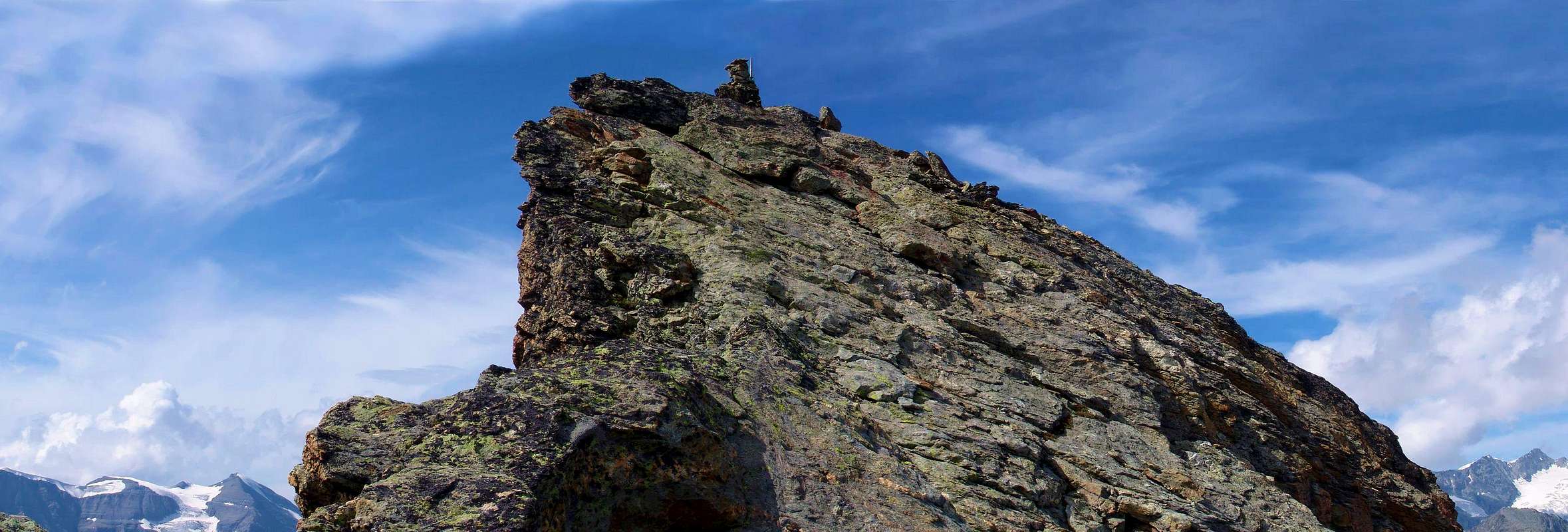
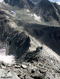
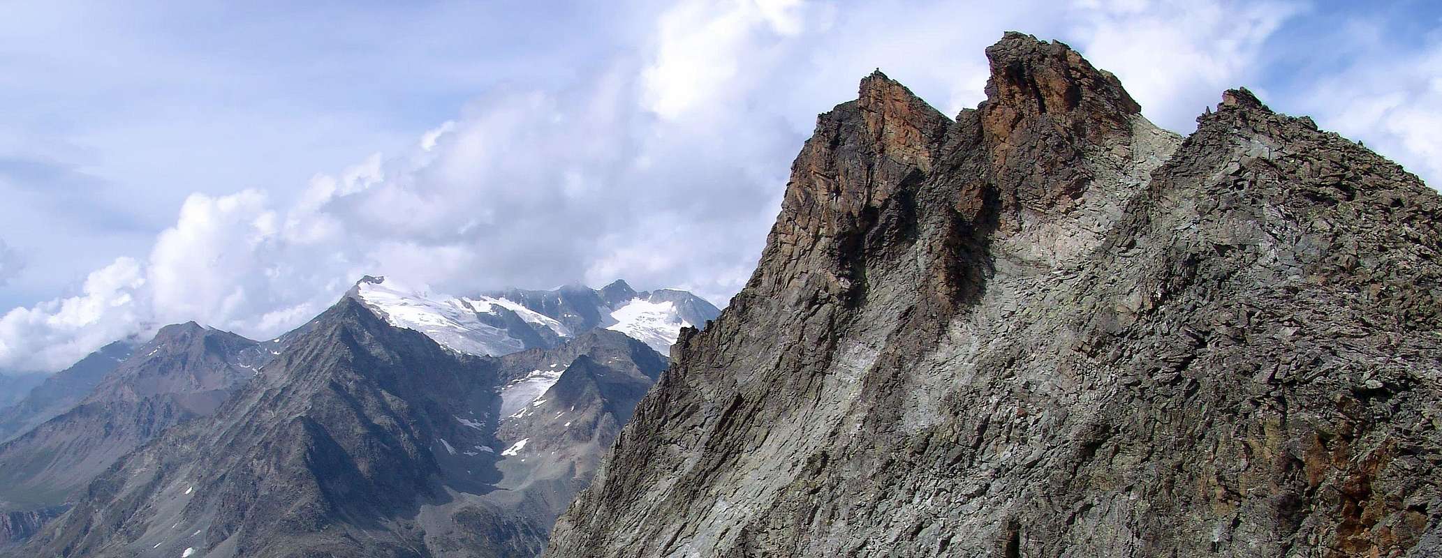
The route from Trouma des Boucs
Trouma des Boucs
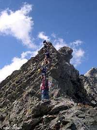
From Refuge Crête Séche or the former Bivouac Franco Spataro (2.600m) cross the "Plan de la Sabbla" moving toward the Crête Séche Pass (2.899m), but not achieve the same. After passing to the right altitude 2.906 meters fall back towards the top of the Comba de Crête Séche is no set path to Col Chardoney (3.186m), below the Becca Chardoney. From this follow the easy and Southeast Ridge, passed a most challenging stretch at the end, the little cairn to reach the Summit (EEA; 2h'45/3h'15 from the refuge). Descent: coming back is along the same route.
Dal Rifugio di Crête Séche o dall'ex Bivacco Franco Spataro (2.600 m) attraversare il "Plan de la Sabbla" indirizzandosi verso il Colle di Crête Séche (2.899 m), ma non raggiungere il medesimo. Superata verso destra la quota 2.906 metri ripiegare verso la parte alta della Comba de Crête Séche e senza percorso obbligato raggiungere il Col Chardoney (3.186 m), sottostante alla Becca Chardoney. Da questo percorrere la facile Cresta Sudest e, superato un tratto più impegnativo nella parte terminale, raggiungere il piccolo ometto della Sommità (EEA; 2h'45/3h'15 dal rifugio). Discesa: per la stessa via di salita.
Difficulty
The route is rated EE/A; from F to F+.
L'itinerario è da classificarsi in EE/A; da F a F+.
Gear
For Mountaineering with rope, ice-axe and crampons.
Da Alpinismo con corda, piccozza e ramponi.
Camping
Remember that free camping is forbidden (except for emergency reasons, over 2.500m, from darkness until dawn).
When To Climb
The mountain is climbed in winter by ski and in summer: march and april for ski and in summer from june to september.
Children refers to the set of objects that logically fall under a given object. For example, the
Aconcagua mountain page is a child of the 'Aconcagua Group' and the 'Seven Summits.' The
Aconcagua mountain itself has many routes, photos, and trip reports as children.
Parents refers to a larger category under which an object falls. For example, theAconcagua mountain page has the 'Aconcagua Group' and the 'Seven Summits' asparents and is a parent itself to many routes, photos, and Trip Reports.


 8175 Hits
 91.14% Score
 34 Votes