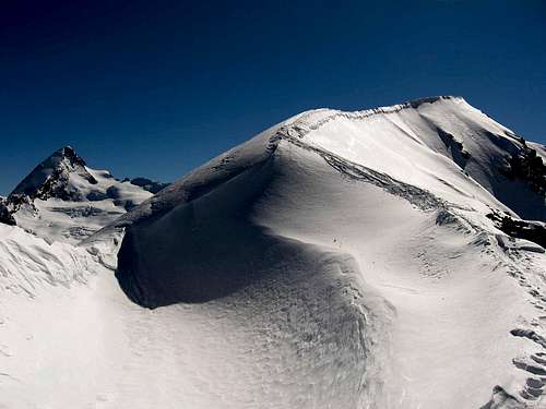
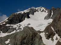
Nice mountain situated in a not very specific area af Pennine Alps on boundary Italy-Swizzerland. The name of it is dedicated to the famous swiss climber/ski-mountaineer/cartographer Marcel Kurz (1887-1967). Is not easy to named this area because this with other summits aren't a part of chains or mejour mountais as the neighbour Grand Combin de Grafeneire and Dent d'Herens. This area may be called "Collon Area", by the important numerous crossings through the Col Collon,often crossed by many routes. Other important Summits of this area are: Gran Becca d'Oren, Eveque, Mont Collon, La Vierge, Mont Brule' and Dents des Bouquetins. It's almost totally covered of ice(impressive the serracs on the North Side), and it's connected by the West-northwest fronter Ridge to the near Mont Brule', and to Becca della Vannetta (3.361m) by the South-southwestern Ridge, through the Col du Laurier Noir (3.291m).
Bella montagna situata in una zona non molto specifica delle Pennine Alpi sul confine Italia-Svizzera. Il suo nome è dedicato al famoso scalatore/ sci-alpinista/cartografo svizzero Marcel Kurz (1887-1967). Non è facile nominare, questa zona perché questo monte con altre cime non fanno parte di catene o montagne tanto maggiori quanto famose, come il vicino Grand Combin de Grafeneire e la Dent d'Herens. Questa zona può essere chiamata "Area del Collon", per l'importante passaggio tramite il Col Collon, spesso attraversato da molti percorsi. Altre Vette importante di questa zona sono: Gran Becca d'Oren, Eveque, Mont Collon, La Vierge, Mont Brule e Dents des Bouquetins. È quasi totalmente coperto di ghiaccio (impressionante i seracchi sul lato Nord), ed è collegato dalla Cresta frontaliera Ovest-nordovest al vicino Mont Brule ed alla Becca Vannetta (3.361 m) dal Crinale Sud-sudovest, attraverso il Col du Laurier Noir (3.291 m).
Who's Marcel Kurz and the origin of cross-country skiing
The origin of cross-country skiing The theories of the origins of cross-country skiing are different: there who want even be traced back to prehistoric times when hunters from the Bronze Age is addentravano in the Alpine valleys with snow moving on leather shoes, following the retreat of glaciers and who content to find in the more recent history of "Esquimesi" or Eskimos or that of Italian Alpine Troops during the WW1. Without trying to go but those that are more than anything else the origins more or less of an ancient search tools to move the snow, there is a specific date that conventionally takes birth as a ski mountaineering: 1893. The affirmation of ski mountaineering, intended as a real sport, it is usually done to coincide with the publication released in 1923, a famous book: "Alpinisme Hivernal" by Marcel Kurz. At the patronage of the mountain during the winter was very timely topic. Kurz's book was a revelation for many, and scored the final development of the practice of mountain skiing. "It was only in January 1893-recalls that the author-Christopher Iselin of Glaris and three of his friends managed to overcome ... the Hill of Pragel (1.554m), crossing regarded as the origin of mountain hiking in ski ". In the same year, in Davos, were born of seal skins, then the famous knives Bilgheri,sticks. Kurz recalls the history of mountain skiing from the precursors to the first hesitant to use experience of skiing in the high mountains and the next triumph with the completion of major crossings like Chamonix-Zermatt: the fascinating saga of what the same Kurz called "second conquest of the Alps.
L'origine dello sci di fondo Le teorie delle origini dello sci di fondo sono diverse: quelle che vogliono persino essere ricostruite nei tempi preistorici quando i cacciatori dell'età del bronzo si addentravano nelle valli alpine con la neve fresca sulle scarpe di cuoio, dopo il ritiro dei ghiacciai e che conprendono per trovare nella storia più recente le azioni di caccia degli "Esquimesi" o quella delle Truppe Alpine Italiane durante la Prima guerra Mondiale. Senza cercare di andare alla ricerca di tentativi varii, ma con quella che risultano come, più di ogni altra cosa, le origini più o meno di un antico strumento di ricerca per suparare la neve, c'è una data specifica che nasce normalmente come sci alpinismo: 1893. L'affermazione dello sci alpinismo, intesa come un vero e proprio sport, di solito è fatta coincidere con la pubblicazione pubblicata nel 1923, di un famoso libro: "Alpinisme Hivernal" di Marcel Kurz. La frequentazione nonché il patrocinio della montagna durante l'inverno era un argomento molto sentito. Il libro di Kurz è stato una rivelazione per molti e ha segnato lo sviluppo finale della pratica dello sci alpino. "Fu solo nel gennaio del 1893 - ricorda che l'autore Christopher Iselin di Glaris e tre suoi amici riuscirono a superare ... la collina di Pragel (1.554 m), attraversando la medesima e con un'azione considerata l'origine degli escursioni in montagna in sci". Nello stesso anno, a Davos, sono "nati" le pelli di foca, poi i famosi coltelli Bilgheri ed i bastoncini. Kurz ricorda la storia dello sci alpino dai precursori al primo tentativo esistente nell'esperienza di sciare sulle alte montagne e nella susseguente affermazione di effettuare il completamento di importanti traversate come Chamonix-Zermatt: l'affascinante saga di quello che lo stesso Kurz ha chiamato siccome "seconda conquista Delle Alpi.
Who's Marcel Kurz (1887-1967) was born in Neuchatel,where he lived and where today the seat of the foundation that bears his name. He was the father Louis, passionate musician, explorer and mountain climber, to start youth in the high mountains. Topograph engineer,Kurz followed in the footsteps of parents working with him to the realization of the first paper scale 1:50.000 in the region of Mount Blanc and the "Guide de la Chaîne du Mont Blanc", which would be transformed over time in the french, famous and renowned "Guide Vallot". He entered a student became part dell'Akademischen Alpen Club of C.A.S., turned his mountaineering activities especially to four thousand: between 1907 and 1920 went up all those Valais. Kurz gathered his experiences in the book "Alpinisme Hivernal", fundamental work for the development of mountain skiing.Later he published three volumes of "Guides du skieur dans les Alpes Valaisannes" and four of "Guides des Alpes Valaisannes".
Chi è Marcel Kurz (1887-1967) è nato a Neuchatel, dove ha vissuto e dove oggi é collocata la sede della fondazione che porta il suo nome. Era il padre Louis, musicista appassionato, esploratore e alpinista, per iniziare la gioventù nelle alte montagne. Kurz ha seguito le orme dei genitori che lavorano con lui per la realizzazione della prima cartina in scala 1:50.000 nella regione del Monte Bianco e la "Guida della Chaîne du Mont Blanc", che si sarebbe poi trasformata nel tempo nella francese nonché famosa "Guida Vallot". Entrato come studente divenne parte dell'Akademischen Alpen Club di C.A.S., ha trasformato le sue attività alpinistiche soprattutto nei confronti dei Quattromila: tra il 1907 e il 1920 ha salito tutti quei Vallese. Kurz ha raccolto le sue esperienze nel libro "Alpinisme Hivernal", fondamentale per lo sviluppo dello sci di montagna. Più tardi ha pubblicato tre volumi di "Guides du skieur dans les Alpes Valaisannes" e quattro di "Guide des Alpes Valaisannes".
Getting There
Area reachable from Italy and Swizzerland
Route from ITALY: Via Valpelline-Comba d'Oren-rif Nacamuli. From Turin, Milan. Leave motorway A5 in Aosta Est, then follow Grand Sant Bernard tunnel direction. Once passed Valpelline village, take the direction to lake of Place Moulin.
Route from SWIZZERLAND: Via Arolla. From Geneva, Sion. Arolla is the topmost village of the uppermost valley of the Val d'Hérens. In former times, you could reach it only on foot. Now, there exists a road. You reach Arolla by car from Sion via Evolène and Les Haudères.
First Ascents & Routes
Very good place fo ski-mauntaineering. The very famous hauteroute Chamonix-Zermatt, passes through this region with same variants.
First ascent: Unknown.
First winter: Unknown.
Northwest Ridge (Standard Route from La Vierge): the Normal Via both caming from Switzerland or Italy. This route usually start from the most recent Refuge Nacamuli (2.828m) nearby the old Col Collon Bivouac (2.816m), frequented even by ski (Classic Via). Difficulty F+/BSA. Generally macthed to the ascent on Mont Braoulé (3.581m).
North Wall (Central Via): Ugo Manera and Gian Carlo Ricompensa, Aug 10th, 1962. This route can change every year in all ic sector. Many seracs and ice falling warning (Apparently safe via, but which requires constant assessment of ice conditions). Ascent entirely on ice with length over 500 meters; difficulty: from AD+ to D/D+. First Repetition?: Jurgen? (Switzerland): "North face Sucess!". Date Climbed: Aug 01th, 2008; Jurgen: "Perfect conditions in the face! We were able to climb it in 3 hours. The serac was very enjoyable to climb. One steep pitch (80degrees). Continued to the Mont Brulé. Descent towards Arolla". (Posted Aug 24th, 2008 4:01 pm). Second Ripetition?: skileraar? (Netherlands): "Vooruit.. laat ik deze dan ook maar even signen: nice route, climbed a week after Jurgen.. Good conditions!". (Posted Sep 11th, 2008 5:34 am).
North Wall (Left Route on rock Central Spur-Direct Route): Osvaldo Cardellina and Marco Périen, Jul 30th, 1970, first ascent round trip in day from Place Moulin towards Collon Bivouac (now flanked by Nacamuli Refuge) and until the Collon's Pass through Southern Slope; descent with the North-northeast Flank on Haut Glacier d'Arolla and traverse before to the Northeast, after Southeast doubling La Vierge (3.232m). Route of over 500 meters before on rock rib, climbing an initial slab in diagonal to the left followed by a small rock couloir narrow often with "verglass" until the hanging snowfield to the right; immediately after on steep ice up to the terminal horizontal ice crevice and finally with direct ascent to the Summit, tilting slightly to the left. The route change every year in the superior sector. Caution: many seracs and ice can falling above the first rock part (much exsposed to the ice falls; very dangerous via, probably no longer repeated). Difficulty AD/AD-/D+/D/AD.
East Crest (to Mont Braoulé): unknown; ice ridge linked with Mont Braoule', short and easy. Pay attention to the North Side (Continuous and small snowy frames; dangerous corniches in the final part, much exposed above the Northern Wall of Mont Braoulé). Continue slightly below the ridge to the right (South-southwest).
Southern Face (from Braoulé Glacier): Osvaldo Cardellina, Sandrino Casalegno, Maurizio Castellan, Marco Cossard and Giuseppe Lamazzi, Jul 15th, 1984, after the ascent (in day from Place des Moulins) on Mont Braoulé with Direct Variant in the last 220 metres (PD+/AD-). Partial descent through the "Gino Buscaini/Silvia Metzeltin Buscaini Via 1970" (Northwest Crest and Western Face) to Braoulé Glacier in altitude about 3.200 meters (F+/PD-/PD+) and ascent, with sinuous line, of ice and rock short wall (about 300 meters). Caution: route often exposed to stones falls; PD/PD+/AD-.
Southwest Ridge (from Becca Vannetta, bypassing Col du Laurier Noir and subsequent Pointe du Laurier Noir): Osvaldo Cardellina, Alessandro Cardellina (10 years), Marco Cossard and Giuseppe Lamazzi, Jun 29th, 1986, in day from Place des Moulins. It's a very long rocky ridge. Unusual route, perhaps it traveled in this unique opportunity. Surely interesting and airyal if connected with the ascention on Becca Vannetta (3.361m). From this last descent on Col du Laurier Noir (3.295m), ascent to North-northeast towards Quota 3.373 meters or Pointe du Laurier Noir and followed Saddle (3.282m), Altitude 3.401 meters (exsposed to the North with some avoidances to the left of the crest) and final part, after a short snowy crest, bypassing various gendarmes and a snowfield to Northeast. Difficulty PD/PD+/AD-/AD.
West-northwest Face (Direct Route): Osvaldo Cardellina, Roy Cardellina, Marina Catani, Marco Cossard, Luca Ferronato, Luigi Gadin, Danilo Garzotto and Giuseppe Lamazzi, Aug. 01th, 1993. After the climb on La Vierge (3.232m) from Col Collon (3.080m), direct ascent from Glacier du Laurier Noir to Summit through the snowy West-northwest Face (snowy slope of 30°/35°/38°/40° for a length of about 350/400 meters. A fun way and without objective dangers. Subsequent crossing to Mont Braoulé to the Northwest Crest by Osvaldo Cardellina, Roy Cardellina, Ferronato Luca "Gigi" Gadin and Danilo Garzotto with descent to Collon on the fronter ridge. All ascents in day from Place Moulin.
West Flank ("Minispur") and in final part North-northeast Crest (Variant of Normal Route): Osvaldo Cardellina, François Pompignan and Franco Stradella, Aug. 19th, 1973. Different, diversionary and mixed climb in the ascent immediately below the altitude 3.283 meters through the small rock spur between the Glacier du Col Collon and Glacier de la Pointe du Laurier Noir, after the ascent on La Vierge with Franco Stradella. Then follow a solitary climb by Osvaldo Cardellina with traverse to Punta Marcel Kurz (difficulty on rock face: from MD-/AD+ to PD+; lengthiness: about 230/40 meters) and towards Mont Braoulé, round trip and new ascent to La Vierge with François Pompignan.
Accomodation
Italian side
Ref. Nacamuli-Col Collon 60 places. 2.828m at the head of Comba d'Oren, 3h'00/4h'00 from the dike of Place Moulin. Open summer and spring for ski-mauntaineering. Difficulty EE.
Swiss side
Ref. Des Bouquetins 25 places. 2.980m at the head of Glacier d'Arolla. 3h'00/4h'00 from Arolla. Open summer. Tel0041 21 845 63 21. Difficulty F.
Cabanes des Vignettes 125 places 3.160m, situated near the "Col des Vignettes". 3h'00/4h'00 from Arolla. Tel. 0041 27 283 13 22. Open summer and spring. Difficulty F.
Mountain Conditions
You can get meteo information at the official site of the Regione Valle d'Aosta:
Children refers to the set of objects that logically fall under a given object. For example, the
Aconcagua mountain page is a child of the 'Aconcagua Group' and the 'Seven Summits.' The
Aconcagua mountain itself has many routes, photos, and trip reports as children.
Parents refers to a larger category under which an object falls. For example, theAconcagua mountain page has the 'Aconcagua Group' and the 'Seven Summits' asparents and is a parent itself to many routes, photos, and Trip Reports.

 12129 Hits
 91.45% Score
 35 Votes