
-
 3400 Hits
-
 79.78% Score
-
 11 Votes
|
|
Mountain/Rock |
|---|---|
|
|
44.88130°N / 109.2643°W |
|
|
Park |
|
|
Hiking, Scrambling |
|
|
Spring, Summer, Fall, Winter |
|
|
5532 ft / 1686 m |
|
|
Overview
 Indian Paintbrush
 Peak 5532
Peak 5532 is a mountain that is situated near the town of Clark, Wyoming. Its location near Clarks Fork Canyon and proximity to the Beartooth Range make for some wonderful summit views, and the climb itself presents a fun variety of challenges, including a 150-yard traverse of the knife-edge ridge leading to the summit. The west side of this mountain is very steep (about a 50+ degree slope) and loose, and the north side is on private property (posted and fenced off), so the ridge on the southeast part of the mountain is the only feasible way to climb the peak.
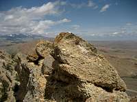 Summit block
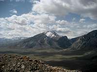 Bald Peak
All of the formations around Clarks Fork Canyon were formed by a rock uplift that slopes downward from west to east, and some of the layers and spires that can be seen on the north side of the canyon are especially impressive. Peak 5532 is about 2.5 miles from the canyon, but it is made up of the same kind of rock formations. These layers of rock can be seen near the summit and a few other places, but the peak is covered in dirt and loose rock for the most part. Plant life is similar to that found on the Rock Benchmark to the south, with lots of wildflowers mixed in among the sage brush and pine trees. Peak 5532 has 832 feet of prominence.
 Summit view towards the Beartooths
Getting There
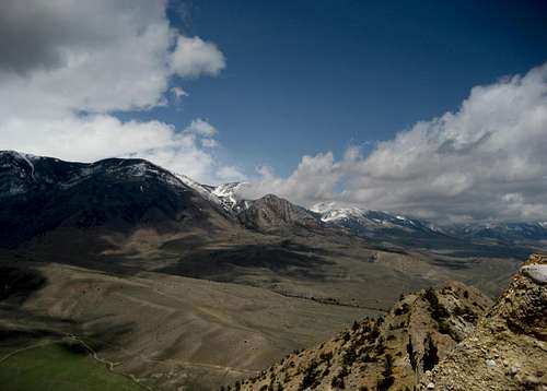
From Cody, Wyoming, follow Highway 120 north for about 29 miles until you come to the Edelweiss area and turn left onto County Road 1AB (292). Travel for 7.6 miles, staying left at the fork which becomes Canyon Road; turn right on County Road 8RA and park immediately on the side of the road. Rock Benchmark
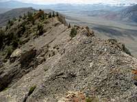 Looking back down the summit ridge
Cross the small creek (which was dry in early May) and head about halfway up the ridge on the left side of the mountain that is closest to the road. Look for the first rock formations off to the right and head right to cross below them. If you follow the ridge past this point, you will reach a dead end. After crossing below the rocks, continue around all of the rock formations until you can rejoin the ridge. From here, head up the steeper section to reach the south summit, which is only about 10 feet lower than the true summit.
At this point you will get your first good look at the remaining climb along the summit ridge. There is about 600 feet of steep exposure off of the left side, and the right side falls slightly less sharply down a gully of about 800 vertical feet. Much of the 150 remaining yards to the summit can be walked, but there are numerous places where both hands must be used and several places where it easiest to sit down and scoot across the exposed slabs of rock. There are two large boulders that are fairly close to each other; the first one you reach is the summit. Crawl under and to the left of the overhanging summit block (watch the loose rock) and climb it from the north side. The summit is very small, so have fun if it is windy!
It is three quarters of a mile and 1,000 vertical feet from the car to the summit, and the climb is Class 2 except for the summit ridge, which is exposed and more difficult Class 3.
 The summit ridge from the south summit