Bakersfield to Horseshoe Meadows
Despite months of trying to nail down a group for our planned stroll up the Mt. Whitney Mountaineer’s route, the final roster wasn’t decided until the Monday before our Saturday permit date. Todd, Niall, and I would be leaving Thursday afternoon (Niall’s flight was to arrive that morning) to head up to the Eastern Sierra for a couple days of acclimatization. Trevor would come over on Friday afternoon from the Bay area. A four-person team was good, although we were certainly sad to be missing Jonathan, who had been the chief organizer for most of my trips to the Sierras, including the Mt. Whitney main trail hike in 2007.
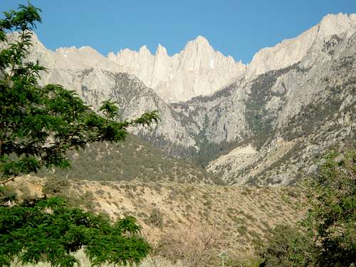
I was really looking forward to the drive over. It is usually full of spectacular scenery as you make the climb over the Tehachapi Mountains to the Mojave Desert, and then head north along the eastern scarp of the Sierra Nevada. As you enter the Owens Valley and come to the town of Lone Pine, the higher peaks really start to rise up and close in on you, along with the White Mountains to the east. The drive this time, however, was a hazy blur, with wildfire smoke cutting visibility to about nothing. I was not happy about this, as I had told Niall that the drive to Whitney Portal alone would be worth the trip.
At the Eastern Sierra Interagency Visitor’s Center north of Lone Pine, a ranger informed us there were more than 2,000 wildfires burning in the state. This explained why we could barely see the Sierras or the White Mountains, which are normally displayed here in such a majestic and imposing fashion that it makes me laugh. Not only was the view less than spectacular, but also it got me thinking about hiking in smoke-filled air. Perhaps this is what caused me to make one of my biggest blunders of the trip. Halfway through the Alabama Hills, nearing the turnoff for Horseshoe Meadows Rd., I realized I had left our permit behind- in the visitor’s center bathroom. This was an unfortunate 20-minute delay, and could have been disastrous if someone had thrown it away assuming it was trash.
The rest of the evening was relaxing, having dinner and a beer at 10,000’ at my favorite campground in California. One of the highlights of the trip was finding the beer we had forgotten after a backpacking trip a month earlier, still nice and cool in the bear bin. We went on a 15-minute hike just for fun, and the thinner air was definitely noticeable. I knew we’d have a head start on the elevation adjustment after a night of camping up here.
![Bear Bin]()
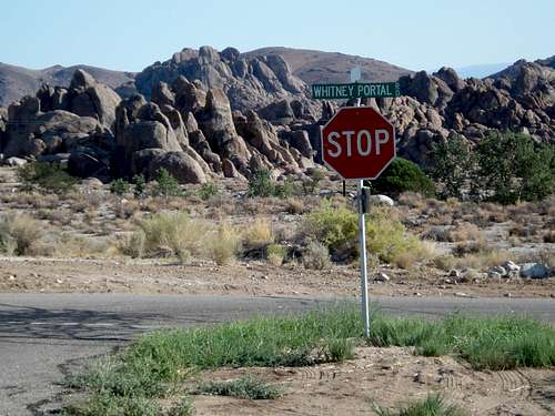
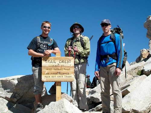
Waking up at Horseshoe Meadows is always relaxing when you’re not among those scrambling to tear down camp and get on the trail. We didn’t hang around very long, just enough time to pack up and eat a breakfast bar or two. By 8 am we were on our way down to the valley. The air was quite smoky again today, but it seemed perhaps a bit better than yesterday. Soon we reached my favorite spot in the Alabama Hills, the stop sign at the intersection of Horseshoe Meadows Rd. and Whitney Portal Rd. I always feel as though it’s somewhat of a warning. Once you make the left turn, you’re heading straight for Mt. Whitney, which is staring down at you in a very imposing and inspiring fashion. In our excitement to get to the portal and set up camp, we decided against checking in at the campground we’d be staying at Saturday night. We hoped to be down early enough that our site wouldn’t be given away.
Whitney Portal and The North Fork Trail
The drive up to the Portal was great, and a bit intimidating, as I had remembered. We soon lost sight of our goal as the walls of the canyon closed in tight. When we got out of the car, I remembered my thinking last year looking up at the spectacular relief on both sides- “we’re going higher than that in one day?”. After getting camp set up, we got ready for our practice hike, the goal of which was to both get the legs and lungs a little warm-up for the big hike tomorrow, and to find the start of the Ebersbacher Ledges, which some trail descriptions seemed to indicate could be a bit tricky. We thought we might be doing that portion of the hike before dawn, so we wanted to have a look and perhaps save some time in the morning.
It’s always encouraging when the trail you mean to take is marked with a sign warning away anyone who does not have superior routefinding skills. The fact that the sign also instructs you to “pack out your poop!” makes it an irresistible photo opportunity. We disregarded the sign’s warnings and started up the North Fork trail. It was steep, but easy to follow. It took longer than expected to find the start of the ledges, and the stream crossings immediately before seemed like they’d be a real treat to do in the dark. After relaxing for a bit, and following Todd on an impulsive scramble up the opposite side of the canyon from the ledges, we made our way back down. One of the descriptions we had read told of a shortcut that leads from the portal parking lot to very near the North Fork and main trail intersection, and we took that on the way back. It took us only a couple minutes less going down the “shortcut” as it did going up the main trail, so we didn’t figure it would make much difference which path we took in the morning.
![This is NOT the Mt. Whitney Trail]()
Dinner was an adventure. The mosquitoes were harassing us so fiercely, I wonder if I had a net gain of calories after moving around and swatting them away. After cleaning up, there wasn’t much to do but start to get packed up for the morning and wait for Trevor to show up. This went on until 9:30, when we finally decided to give up and go to sleep. About 10 minutes after getting in my sleeping bag, I heard from Todd that he had finally arrived. I was relieved to finally have the wait over with after trying to reach him all afternoon. I was also nervous about how he’d do on the hike after getting in so late, my tiredness overwhelmed my concerns and I was able to get some sleep.
The alarm went off at 4:00 am, and I was wide awake. I hit the snooze a couple times before calling the others, who were probably also awake, if not yet out of their bags. It felt good to get moving, the anxiety and anticipation put on hold while completing the necessary tasks of dressing and tearing down the tent. Similar to last year, my thoughts quickly turned to my goal of removing any waste I could in the outhouse before setting off. We were pretty slow getting things packed up, and Niall and I were the first two at the trailhead, just before 5:00 am. Waiting for the others, Niall elected to set off on the trail, and I stayed behind to make one last bowel evacuation attempt before shutting it in for the day. Todd and Trevor made it up a few minutes later, and also opted for a final trip to the outhouse. We started on the trail at 5:15, and it was already light enough for us to pack our headlamps.
Trevor’s pack was huge. I told him it was huge, and “that’s what she said” made its first appearance of the day (and not the last). He weighed it on the scale at the trailhead, and it came in at 24 lbs. I was less than optimistic about someone who had done no acclimatization and carrying enough weight for an overnight backpacking trip making the 6,000’+ elevation gain, but I wouldn’t bet against Trevor. Todd convinced him to drop some items from his pack and hide them off the trail, and a couple of these stops meant that Niall ended up waiting for about 15 minutes for us at our turn off.
Once again, the North Fork trail got our legs and lungs working hard. Just before heading down to the stream crossings and the start of the ledges, we met another hiker who was planning to go up Mt. Russell. He set off while we waited for Trevor, who had decided to lighten his load again (internally this time) before starting the scramble up. While we waited, we were able to spy another group making their way along the ledges, which gave us some ideas on where to go after passing our stopping point from the previous day.
The scramble up and the traverse was fun, very exposed, and mostly easy, other than a couple spots that looked like they might be tricky for a shorter individual like myself on the way down. I was definitely glad to be carrying only a daypack, and not a full backpack. After finishing a couple zig-zags to the upper ledge, the path to Lower Boy Scout Lake was another section of easy but steep trail.
We finally reached the lake, but even before dropping the packs for a break the next obstacle on the route was quite obvious, a section of low angle granite slabs leading up from the far side to Upper Boy Scout Lake. Little did we know that before negotiating the slabs, some route-finding confusion would give us a nastier problem to solve. There were paths leading both to the right and left of the lake, and we chose the right, hoping to avoid some of the boulder-hopping that looked prevalent on the left side before reaching the slabs. After passing the lake, it didn’t look like there was a good path to get over to the easiest entry point for the slabs up ahead, and we could see the trail at the base of the boulder slope across some marshy ground, so we decided to try to cross over to it. Soon we were fighting through some very dense willows, and had to cross a stream a few feet wide. I would have had a tough time getting across without jumping, and the thick willows made this impossible, so Niall stuck his trekking pole across, and I used it for leverage to pull myself over. The diversion probably cost us 10-15 minutes and drained a bit of energy, but we figured it just gave the hike more character.
The slabs were a fun variance from steep dirt trails. We didn’t know precisely where on the horizon we should be targeting, so we just followed the cairns that were spaced out every couple hundred feet or so. They didn’t appear to be leading in any one particular direction. Mt. Whitney made an appearance while we were working our way up, and it was quite a sight. It looked a long ways off, and still very high. We were not almost there. We saw the Mt. Russell hiker again across the way up higher on a snow slope, and we wondered if he had chosen the better path. He yelled something to us at one point, but we couldn’t make out what he said, and continued on.
![Slab skipping]()
Eventually we reached the top of the slabs, and ran up a very steep section of trail to the level of Upper Boy Scout Lake, which was a ways off to our right. In all the trail descriptions I had read, the route from Upper Boyscout Lake to Iceberg Lake, which I knew to be a common camping spot and staging point for the mountaineer’s route as well as east buttress climbers, was described very vaguely. There was some talk of a glacial moraine landscape, but most just said things like “if you’re doing the hike in a day, you’ll just blow on by Upper Boy Scout and make your way up to Iceberg Lake”. Very helpful.
Now our unfamiliarity with the route finally caught up with us, as none of us knew the best path to take. After milling around near the lake for a while, getting a snack and a quick rest for the legs, the Mt. Russell hiker met up with us again. He was planning to summit via the West ridge, and his approach took him past Upper Boy Scout Lake. He mentioned that he had taken the less direct path on the snowfield earlier to avoid boulder hopping as much as possible. We should have asked more questions about the best way to the start of the mountaineer’s route, but instead just wished him luck on his hike and went our separate ways. It looked like the lake was rimmed on three sides by steep ridges, and so we worked our way south taking the easiest looking slope to try and find a way up. We found what looked like it could be a use trail, and followed it up and along the south side of the ridge. It was fairly slow going, and there wasn’t a nice route to the top that we could see.
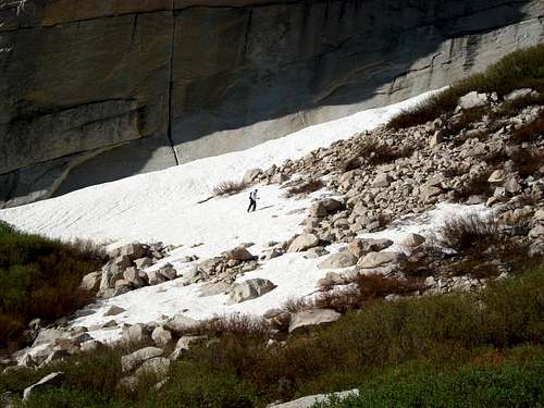
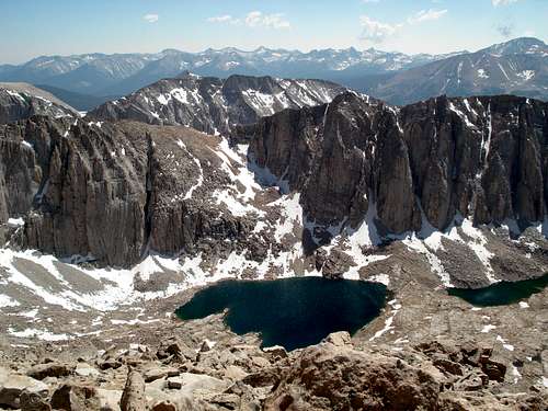
We were all running a bit low on water by this point, and were hoping to fill up at Iceberg Lake, but were now beginning to regret not filling up earlier when we had the chance. After some more trudging along underneath the cliff face, we found a small stream that would serve for a fill-up. Once that job was done, much to our relief, we started trying to locate where we were and where to go next. Todd was under the impression that Iceberg Lake was ahead and to our left, hidden behind a big boulder pile in the valley. This didn’t seem right to me, because I remembered Iceberg Lake being on the North side of Mt. Whitney, and we knew that Whitney was off to our right, not our left. This was obvious once we were above the level of the boulder pile, and not a drop of water was to be found. After some rambling, and second-guessing of our path, Todd calmed me down, and we agreed that Iceberg Lake was on the other side of the ridge we were walking along, so we simply had to find a way over it. Eventually, we found a route that just might work, although it didn’t look easy. We’d have to work up and across another set of ledges, and these looked like they might just lead to a point where we could scramble over the top. Overall this worked out quite well, but there were a couple tricky spots, one of which included traversing snow melt trickling down over some steep rock, which looked like it might be icy. Luckily it wasn’t, but the apprehension on my part cost us some time. Eventually, we made it up and over the crest of the ridge, and there was Mt. Whitney, staring us in the face. Now it was quite apparent where we were headed next. As we made our way over to the camping area near Iceberg Lake, we were all impressed at the size and steepness of the East Col, and how much elevation we had yet to gain. As we sat eating a snack before setting off, Todd was the most optimistic about our chances, suggesting “it won’t seem as steep once we get closer”. I didn’t quite know how that could possibly be the case, but I tried really hard to make myself believe it.
![User Profile Image]() Wow.
Wow.The Mountaineer’s Route
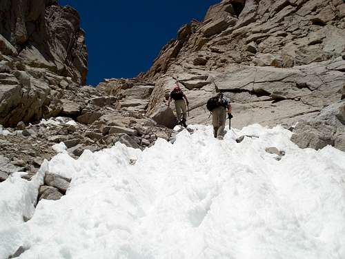
"Well, we’re here, may as well go have a look at her”, I said, and moved to pick up my pack. The others followed, and we made our way along the trail to the base of the East Col. We lost the trail a few times, and just sort of made our way up the rocks and scree until we reached the level of the snow, which covered the center of the steep gully most of the way up. In retrospect, the boulder scrambling was likely the faster and easier choice, but already tired from lots of uphill marching, the nice steps in the snow looked comparably easy and inviting, so we made our way down and right into the couloir. Looking back towards the lake, we could see another trail leading up from the opposite side of the ridge that we had come up. Potentially this would be a more direct (and hopefully easier) route down.
The steps were great, and the climbing was easy going up. Occasionally a sloping or icy step made me glad for having my ice axe, but mostly they were only necessary for balance, and I was happy to have left the extra weight of my crampons behind. After about 20 minutes of climbing steps, taking 10-second breathing breaks every 10-15 steps, the sun began to be very noticeable. Thinking of keeping my breathing deep and steady, pretty soon we were high enough to look up and down and get a true sense of how long this snowy staircase was. I also began to realize why pictures on internet trail descriptions tend to be mainly from the base or the top of this slope, and hardly ever from mid-way up. While the steps were nice, it wasn’t worth the risk of twisting and fidgeting with my pack to get my camera out to try to capture the length and steepness of the slope.
Todd had led up the slope, with Niall and Trevor following, while I hung at the back. This was nice for me, as those in front were improving the steps as they went, leaving me little work. That went well until I fell about 30 feet behind Trevor. There were so many steps and sun-melted holes, I quickly lost the train of steps the others were using. The steps were also quite far apart for my short legs, making it more difficult to keep up the pace. A little over halfway up, Todd had to take a break due to some mild nausea, likely from the effort of leading the way. Smartly, he decided to have a snack to get some energy back, always a tough thing to do with an uneasy stomach. At this point, Niall and Trevor began a terrific effort leading the way to the top of the snow, as they were both ready to be done with it. I gave my best effort to catch up, reaching the end a couple minutes after them. Todd joined us shortly after for what we thought would be easier going now that we were done with the heat and monotony of the snow steps.
![From Snow to Scree]()
Our gratefulness lasted only briefly, as we begun slogging up the loose scree and any welcome boulders we could find. I thought later how miserable a mid to late summer trip up the route must be, and how nice it would have been having snow all the way to the top. We were moving along fairly slowly, but finally reached level ground below the notch on the North side of the mountain. At this point, the group was feeling ok, but everyone was tired and ready to be at the top. We reached what we thought was the class 3-4 scramble onto the summit plateau. Unfortunately, the class 4 bit is at the beginning, and after some discussion we decided on the “easy traverse”. As I had been prepared for by some good route descriptions, the easy traverse is not easy. More loose scree and boulders, with no obvious route to follow. We made our way along the North slope below the summit plateau, unsure where to attempt to climb higher. A few scattered cairns kept our spirits up, and finally when we got to a section that looked manageable, Todd offered to climb up and have a look over the ridge to try and figure out our next move. Much to our relief, he announced that he was on the summit plateau, and had found the trail to the top. The rest of us made our way up and we had a mini-celebration, and one heck of a view.
![The Easy Traverse]()
At this point, we discussed what route we would take down. I was more in favor of taking the main trail down, for two reasons. First, it would be much less risky with a tired group to follow a trail with a comparably easy grade than going down the steep scree and snow-filled gully we had just come up. We had all nearly made it to the top, and I was ready for the difficult work to be over with so we could just enjoy the rest of the day. Second, there are great views in to Sequoia National Park along the way to the trail crest, and I wanted Niall and Trevor to see them, and also what the main trail route was like, as they hadn’t been along for that trip the previous year. Todd advocated taking the Mountaineer’s route down for the obvious reason of a speedier decent and earlier arrival back at the portal (he had remembered how long of a slog the main trail is). We were both willing to take whichever route the majority decided on. Niall and Trevor didn’t have strong opinions either way, and without actually taking a vote we came to an agreement that we’d take the easier path and follow the main trail down. With that decision made, my anxiety was completely gone, knowing the only hazard remaining was taking care not to turn an ankle on the way down.
After another 15 minutes of walking, we could see the summit hut, and I became a tourist, happy to be back at a neat place I’d been before, and eager to see the reaction of those taking it in for the first time. We reached the summit blocks a few minutes before 2 pm. The hike up had taken us an hour or two longer than we had anticipated. The air was surprisingly even clearer than the previous year, with wonderful views in every direction. The mosquitoes at dinner and Trevor’s very late arrival the night before, the willows and other rout-finding difficulties on the way up, the endless snow, scree, and sun in the East Col, all of this seemed now just to be part of the fun, making our trip a story worth telling. I was happy our whole group had made it to the top, for the most part feeling very good. I was especially happy for Niall, that his trip out had now certainly been worthwhile, and that he’d been able to perform so well despite having done no hiking at elevation all summer.
![Summit Hut]()
We hung out on the summit for 40 minutes, chatting with other hikers, eating some well-deserved snack, signing the summit register, and taking lots of pictures. Now we had a new goal in mind, getting back to the trailhead for our victory dance, a beer at the Whitney Portal store (not to mention dinner and a sleeping bag).
Down the Mt. Whitney Trail
The trek along the back side of the mountain was easy going, and the views were spectacular. I was very happy with the decision to come down on the trail.
![Main Trail Views]()
About two thirds of the way to the trail crest and the start of the long decent, Trevor was getting quite tired, and also low on water. I gave him my reserve water bottle, as I still had plenty in my bladder to get me down to the lakes below. Once we passed the trail crest and started down on the switchbacks, Trevor’s pace started to slow even more. I stayed behind him for a while, but he stopped for a quick rest break and said I could go on ahead. He seemed fine, and I went on to try to catch up with Todd and Niall. Todd eventually found a good spot to fill up our water supplies about halfway down the switchbacks, and Trevor caught up to us there. It was at this stop that Todd found the Gatorade he had been looking for earlier on the snow slope. He was at once glad that he had in fact remembered to pack it, and a bit upset that he hadn’t been able to find it when he needed it the most. Having the water situation in hand, we set off on the seemingly endless march down. And it did seem endless. Todd had certainly been right about that.
![Trail Crest]()
We only took one brake longer than a couple of minutes the rest of the way back. The trudging was monotonous, the feet were beginning to get sore, and the sun seemed as eager to set as we were to get to the portal. In some ways it was enjoyable to see areas along the trail that I remembered from the year before, except for the realization that there was still a long way to go as we passed each one.
Finally, we started the last set of switchbacks, and the mixed feelings of happiness at being nearly finished, and exhaustion as you realize just how wiped you are after walking all day long, begin to set in. Everyone had been mostly silent for a while, and now talk finally started again as we got closer to the trailhead. We arrived at 7:45, having taken 14 ½ hours to complete the loop. We had to hurry over to the portal store to get our beer order in before they closed. We got set up with our victory beers out on the patio, and had another few minutes of relaxation before we had to figure out what to do for dinner. I made my post-hike trip to the outhouse, and we made our phone calls to let people know we had gotten up and down safely.
![Victory Dance]()
The trailhead campground wasn’t full, and we probably could have just set up camp there for the night, but our rule-following nature won out. We also decided to head down to Lone Pine for dinner before returning to the campground where we had a site reserved. We were all so hungry that we decided on McDonalds after seeing how crowded the restaurants were in Lone Pine. Trevor mentioned that he might try to head back to Bakersfield after dinner, and despite our attempts to convince him to come back to the campground, the prospect of his own bed after a week on the road was too tempting. Upon making it back to the campground, we learned that our site had been given to someone else, so we had to go driving around to find an empty spot. There were lots of parties going on, but I wasn’t worried in the least that it would keep me from sleeping soundly. We set up camp, and I was out by 10:30. Waking up in the morning, the happiness of a mission accomplished was just as strong as the soreness in the legs. The view of Mt. Whitney and the route we went up in the distance made me laugh. What a trip.
![The Morning After]()


Comments
Post a Comment