Preface
Being that the tallest mountain in the lower 48 is 3 ½ hours away from where we live, we decided it was about time to go bag the summit. I’ve driven past it for years heading up towards Bishop and Mammoth Lakes areas, but never summated Mt. Whitney.
We planned the trip in January and new we wanted to make an attempt at the Mountaineers Route in mid to late spring. The team consisted of four people: Jeff (the sheriff), Steph (the pastor) and Matt (the teacher). We had all been training together for a while but slowly and surely people started dropping like flies. Jeff was the first one to bail. We had gone up for a quick hike up in the San Bernardino Mountains and he had some leg problems so he decided it’d be best to not go. Steph was next to bail the day before the trip due to work issues, so it was down to Matt and I. This changed the pack situation greatly. I was looking forward to my 22lb pack with three people but with Steph dropping, it made our packs jump up to about 38lbs give or take.
Thursday night came and we were off by 6:30pm, after saying goodbyes to our loved ones. We drove straight through and got to Lone Pine by 5 after 10pm. We stopped at the self register box for our permit and then headed up the mountain only to find a large “ROAD CLOSED” sign. Naturally this was not okay with us, so we decided to move the sign and drive up to find about 8 other cars at the portal. We spent the night there. I spelt outside in my bivy while Matt slept in his car. Finally got to sleep around 11:45pm.
Day 1 – Portal to Base Camp (below Iceberg Lake)
![Early Morning Sunrise...]() Beautiful Sunset Morning of our First day From Whitney Portal
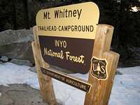
Beautiful Sunset Morning of our First day From Whitney Portal![Whitney Portal]() Whitney Portal Sign
Whitney Portal Sign5:50am came very fast but I was awake and ready with anticipation of the day. We boiled some water to make oatmeal, gathered our gear together and hit the trail by 7am. There were two guys who had parked next to us who left about the same time as us. We ended up hiking with them for a majority of the day, especially since neither Matt nor I really knew where we were going and one of the other guys had done the route 3 times before.
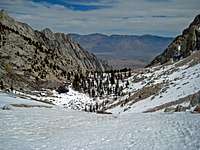
We headed up the South side of the canyon and steered clear of the ledges (bad story about the ledges later). We eventually crossed the creek and followed the end of the semi well traveled trail up to Lower Boy Scout Lake where we took a breather.
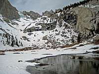
![Leaving LBSL]() Looking back at LBSL, and almost to UBSL
Looking back at LBSL, and almost to UBSL![LBSL]() Looking at LBSL and the next ridge to UBSL
Looking at LBSL and the next ridge to UBSL
After a few minutes we headed on and started making our way up to Upper Boy Scout Lake. We got up about 50 feet on the ridge and decided it was time for snowshoes. It’s funny how they are highly debatable if you’ll use them or not, but we figured since it was spring time and most likely soft snow, we might need them AND WE DID! Once we put the snow shoes on it was smooth sailing. We hauled to UBSL, where we had lunch. After a PB&J, we made the steep assent from UBSL to the ridge between UBSL and Iceberg Lake. We tried to make it all the way to Iceberg but decided right before the last chute that we were going to stay below the ridgeline and make camp. We found a nice little rock area with decent wind shelter (or so we thought) and set up shop. We were both pretty tired and slightly dehydrated so Matt got right to boiling snow. We wanted to each get at least 1 more liter in before bed.
As he was getting water for us, I was setting up the tent. I’m not sure what I was thinking but I got it set up and walked away to go get the stakes and out of no where a huge gust of wind came up and started blowing the tent, end over end, away!!! Away and Away it blew about 100ft. I started springing across the 30degree snowfield sinking a lot into the snow and finally the tent stopped between some rocks. I caught up to it and grabbed it. I THEN REALIZED I HAD THE WORST HEADACHE EVER. ***NOTE*** - Don’t sprint at 11,500ft unless it’s chasing after your shelter!
![Base Camp below Whitney]() Our basecamp at 11,500ft. Mt. Whitney in the background
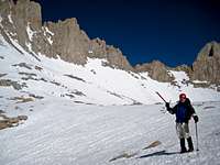
Our basecamp at 11,500ft. Mt. Whitney in the background![Matt approaching UBSL]() Matt, almost to UBSL. The weather this day was amazing!
Matt, almost to UBSL. The weather this day was amazing!
We got the tent back to camp, staked it down, threw a rock in the corner of the inside as well just for extra protection and had dinner, drank water and got in bed by 6:30pm. I didn’t realize how cold it was but it got pretty cold. My fingers were getting REAL COLD so I grabbed the bottle we put the boiling water it. It was nice and warm so helped defrost my fingers. I was asleep by 6:35pm.
Day 2 – Base Camp to Summit & Summit to Portal
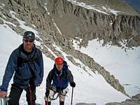
![Matt & I on MR]() Matt and I about Half Way up the MR
Matt and I about Half Way up the MR![Looking towars the Mountaineers Route]() Looking up towards the Mountaineers Route
Looking up towards the Mountaineers Route
6am came way to fast. It was pretty cold as well during the night. (I think I need a new sleeping bag, my old NF Synthetic bag isn’t cutting it anymore) We rose and started boiling more snow for the days journey. Several parties passed us as we were getting ready, including a party of 10 from San Diego. We were on the trail by 8am heading to Iceberg Lake. We made it up the final chute to Iceberg with no troubles and saw the large group ahead of us. We were shocked to see them so close to us, considering they passed us 45 minutes before.
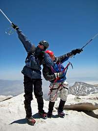
We started heading up the mountaineers route. It was VERY WELL TRAVELED. Lots of packed snow and several switchbacks heading up the first few hundred feet made it very simple. Eventually we got to a point where we decided to harness and rope up for the rest. We got to the notch where it became EXTREMELY WINDY!!! Several people headed towards the traverse but we decided to go the normal route. This was the only part of the route that Matt and I were slightly nervous about considering everything that people had told us about it. After a few feet of 4th class and a nice long steep snow chute, we had reached the summit! IT WAS THE WINDIEST SUMMIT I’VE EVER BEEN ON! We stayed for about 20 minutes taking some pictures and enjoying the views to the west of Kings Canyon and Sequoia National Parks. So beautiful!
We started heading down and made it back to base camp where we gathered the rest of our gear and headed back down the mountain. A few hours and a few thousand feet later, we reached the ledges. We were too high to cross where we did the first time and we ended up getting lost on the ledges. We missed a turn somewhere and ended up way to far down the ledges and very high! We had to turn around and luckily Matt found where to go. We made it out before dark and headed to the Carl’s Jr in Lone Pine for a quick chicken sandwich before heading back to Rancho.
All in all it was an amazing trip. It was good to knock out Whitney from our list of CA 14er’s that were doing. Highly recommended for anyone to go and attempt it.
![Summit Pose]() SUMMIT POSE
SUMMIT POSE


Comments
Post a Comment