The Challenge
Over the years I've done a Whitney Loop dayhike where I try to do just a little bit more each time. In 2007, during Bob Burd's Sierra Challenge, I used the acclimation I had gained over the week to summit 10 peaks (if you want to call them that) in the Whitney vicinity. Afterwards (even though I was physically destroyed) I wondered if I could have done more. I later gave it another try but had to abort early due to deteriorating weather and lack of acclimation. Then in 2010 I suffered a severe ankle injury which threatened to keep me from attempting such extreme adventures (perhaps for the rest of my life).
In the past few months I've been tagging Sierra Peaks pretty much every single weekend. By last weekend I figured I was in the best shape I would ever be at this point in my life ... but was it good enough? Nearly every single weekend lately I failed to tag all the peaks I had intended to. Was I trying to bite off more than was realistic? Or am I basically getting old and have no hope of returning to the days of glory? I wasn't entirely sure. Fortunately the ankle had become less of an issue but it certainly doesn't like some of the hikes I do.
I decided it was time to test myself. The Whitney Loop would now become a Whitney Basin Traverse (similar to Fiddler & Moynier's basin traverse described in their book but with a focus on tagging as many peaks in a single day as possible while avoiding the most difficult terrain). I had a particular selection of peaks I was hoping to summit. The traverse would start with Carillon at the north end and then finish with Lone Pine Peak at the southern end. Or at least that was the goal.
Peak 3985m
![Peak 3985m]() Peak 3985m
Peak 3985m
I had intended to start earlier but a fire near Big Pine caused a closure on the 395 and my meticulously planned schedule was then hosed. By the time I got to Lone Pine I would now only have 2 hours to sleep before my intended 2am start time. I had almost decided to give up without trying. I figured I was more than likely going to fail anyway. I didn't really have a backup plan though so I decided to go ahead. I gave myself 1 additional hour of sleep and started off from the Portal at 3am.
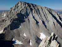
Perhaps the biggest threat to success I faced was what is simply referred to as "Peak 3985m". This is an unnamed peak or ridge between Mount LeConte and Lone Pine Peak. It's basically just class 3 (with maybe 1 or 2 easy 4th class moves if you do it right) but the navigation is difficult and the ridge is tedious. Since I had done this ridge once before (from south to north) I felt compelled to do it the same way. Bob Burd had reported getting into some tricky 5th class when he attempted the ridge in the opposite direction. I didn't want any unnecessary complications. The problem was that by doing the loop in the counter clockwise direction I'd run the risk of hitting Peak 3985m at or after dark. Since the navigation is tricky enough during daytime I figured getting caught on the ridge after dark would almost certainly result in a bivy and failure. Thus, the entire day the threat of that one peak kept me moving. If I ran out of light before reaching it I'd basically just have to abort early. It might still be a big day but I wouldn't achieve my primary goal (to traverse the entire Whitney/Meysan basin area).
Whitney and Beyond
![Whitney s North Face]() Mount Whitney
Mount Whitney
Because I had done Russell, Carillon, & Whitney many times I was quite familiar with this terrain. I went up the sand slope from near UBSL to the Russell/Carillon saddle, tagged Carillon, went up the east ridge to Mount Russell, descended Russell's south face, and then ascended Mount Whitney via the north face / slope. It pretty much went like clockwork and indeed I reached the summit of Mount Whitney in just under 7 hours (after also having summitted both Carillon and Russell). I was pleased with this time and felt more optimistic about my chances.
After Whitney I tagged the trivial summits of Keeler Needle and Crooks Peak. Then down the trail and up to Muir followed by Trail Crest and the Discovery Pinnacle. Last time I ended up having to abort off the side of the ridge to get to Marsh. I thought I could do better this time but in the end had to do the same thing. It was just before 1pm when I summitted Mount Marsh. And thus ended the easier half of the day.
![Mount McAdie]() Mount McAdie
Mount McAdie
After Marsh the crest becomes extreme. To avoid it (yeah it would be sweet to climb it but I'm just not that kind of soloist) I would have to descend down the bowl north of Crabtree Pass. It doesn't look like a big deal until you get into it but this area is very unpleasant with a cliffy section followed by a substantial amount of broken boulders / talus. I had hoped I could hit this area more effectively this time but no dice. It sucked just like last time. It took about an hour to get to Crabtree Pass which was followed by the difficult ascent of a loose talus/boulder filled chute up to the McAdie notch. This was just as unpleasant as I had remembered.
I reached the summit of McAdie at 3:24p, then on to Arc Pass, and up to the Irvine/Mallory saddle. At this point I started to go for Irvine but after some time calculations it didn't appear I'd have time (and it's slightly off the loop) so I very reluctantly decided to leave it. Since Fiddler & Moynier didn't include it in their traverse either I didn't feel it was an absolutely mandatory peak. So it was then onward to Mallory after negoitating the gendarmes on the ridge. On the summit of Mallory it was now 5:44pm and I definitely began to feel pressed. After Mallory it was on to LeConte where I passed 2 climbers who were just completing a traverse of the Langley-Corcoron-LeConte ridge. After getting down off LeConte I could now see that Peak 3985m was now mostly in shadow. I raced over to it and started up the ridge as quickly as possible. Unfortunately even though I had done it once before everything seemed new. None-the-less I worked things out and hit the summit of the ridge at 8:32pm. There was still a fair amount of ridgeline to deal with but I was pretty sure I was in good shape at this point. I ran out of light before getting off the ridge but only had to do 1 or 2 tricky moves in the dark. Beyond this point I knew I had only one more summit left and no tricky terrain so I was quite relieved.
Lost
Once on the Lone Pine Peak pleateau it was quite dark and I followed my gps (and prior knowledge of the area) up to my final peak. I summitted Lone Pine Peak (my 13th "peak") just before 10pm.
After that I thought everything would be easy. I've been here a number of times in the daytime so even though it's dark I should easily be able to find my way down. I knew not to descend the wrong chute down to the Meysan basin and so I was quite meticulous in following a trail and ducks as well as looking around at the terrain in the dark. I found the "correct" chute, followed an obvious use trail, and descended (with a ridge on the right as I remembered). It didn't take long though before I encountered something I didn't remember. Things seemed to be dropping away quicker than I expected and it just didn't look right. I was perplexed because I knew I was where I should have been. I explored one direction then the other assuming I must just be too far to one side or something. Unfortunately by using the high beam on my headlamp I exhausted the batteries just when I needed them most. No problem, I'll just whip out my spare batteries. Unfortunately these had gone missing and I was then down to a keychain light I carry as a backup. I felt a bit desparate at this point and there was a significant possibility I could go over 24 hours if I couldn't work it out in time. I finally decided to reascend to see if I could figure out what went wrong.
Back above the chute it didn't take long to see that another use trail continued on over to the next chute. Ahhh! Problem solved. So now it's a quick descent down the correct chute right? Well, in the daytime it is, but at night it sucked. I kept slipping and falling on my ass and it took a lot longer than I expected.
Finally I reached the bottom and tried to find my way to the Meysan Lakes trail. Again, during daytime this wasn't too difficult, but somehow I ended up in some evil maze of swamp, lakes, and streams. Even with gps it was very time consuming to get my way to the trail because of all the water obstacles in the way. Damn it! I didn't come this far to fail so close to the trail! Anyay, I finally worked it out and once on the trail I knew it was just a matter of time. Down the endless switchbacks (damn you evil trail builders!!!) and then finally down to the Portal campground area around 2am. That was then followed by what seemed like an hour long hike back up the road to my car (in reality it was only 15-20 minutes). A long day to be sure but less than 24 hours and a complete traverse of the Whitney/Meysan basins.
Peaks
Carillon 13552,
Russell 14086,
Whitney 14494,
Keeler 14240+,
Crooks 14080+,
Muir 14015,
Discovery Pinnacle 13680,
Marsh 13550,
McAdie 13680+,
Mallory 13850,
LeConte 13960+,
Peak 3985m 13016,
Lone Pine Peak 12944
Log
03:01a - Left car (approx)
03:05a - Portal TH
03:22a - North Fork trail junction
03:49a - E Ledges
04:11a - LBSL
05:58a - Topped out on the upper plateau
06:35a - Summit Carillon
07:27a - Russell East summit
07:36a - Russell West summit
08:21a - Snow patch between Whitney & Russell
10:00a - Summit Whitney
10:26a - Summit Keeler
10:42a - Summit Crooks Peak
11:19a - Summit Muir
11:36a - JMT junction
11:41a - Trail Crest
11:50a - Summit Discovery Pinnacle
12:50p - Summit Mount Marsh
02:08p - Crabtree Pass
03:24p - Summit McAdie
04:12p - Arc Pass
05:44p - Summit Mount Mallory
06:37p - Summit Mount LeConte
07:34p - Starting up ridge to Peak 3985m
08:32p - Summit Peak 3985m
09:10p - Off the ridge and onto the plateau
09:56p - Summit Lone Pine Peak
01:54a - Start of the Meysan Lakes trail
02:16a - Back to the car
Stats
Total time: 23 hrs 15 mins
Time from Portal TH to Whitney summit: 6 hrs 55 mins (via Carillon & Russell)
Time from Russell to Whitney: 2 hrs 24 mins (via North Face)
Time from Portal TH to Trail Crest: 8 hrs 40 mins
Time from Trail Crest back to car (via Meysan Basin): 14 hrs 35 mins
Topo
![My Track]() My Track
My Track


Comments
Post a Comment