
|
|
Area/Range |
|---|---|
|
|
Hiking, Mountaineering, Trad Climbing, Sport Climbing, Toprope, Bouldering, Ice Climbing, Mixed, Skiing |
|
|
Spring, Summer, Fall, Winter |
|
|
9500 ft / 2896 m |
|
|
Overview
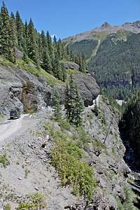
Camp Bird Road is a dirt road, located above Ouray. This road provides an access to Yankee Boy Basin and Imogene Pass. The road starts at the elevation of 7800 feet and continues up to Yankee Boy (the elevation over 12,500 feet = dead end), or over the Imogene Pass 13,000 and down to Telluride. Most of the ice climbing is around 9500 feet elevation. The road is very popular in the summer with 4 wheelers and high clearance 4WD vehicles, during the winter the road gets plowed only for the first 4 miles - to the Senator Creek area. There is usually a gate, and you cannot drive pass this area. Even if the gate would be open, do not drive further. The snow gets very deep, and the road is very exposed, some parts of the road may be buried in the snow and huge icicles often fall from the cliffs above. There is an avalanche danger on the road, always check the conditions before venturing out.The road is named after a mining company called Camp Bird. Camp Bird Mine was the second largest gold producer in Colorado in 1898 to early 1900s. The company was responsible for building this exposed and at some sections very dramatic road.
 Busy weekend day Busy weekend day | 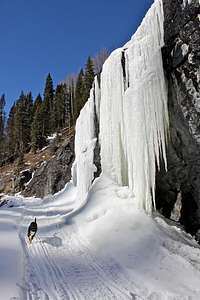 Camp Bird higher up Camp Bird higher up |  Dramatic section of the road Dramatic section of the road |  Dry Tooling Dry Tooling | 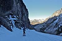 Cross country skiing Cross country skiing |
The Camp Bird Road area is very popular with ice climbers due to the abundance, variety, and quality of routes that form just a short distance from the road. There are more than two dozen climbs in this area, primarily appealing to intermediate and expert climbers. The majority of climbs here form from the snowmelt, so this area may not come into shape until mid- to late winter, but I have done some climbs there as soon as late November, and the ice was ok.
Always check for an avalanche danger prior going to this area. The Ribbon area is especially threatened by avalanches. Above the Ribbon is a large deposition zone, and climbers heading towards Birdbrain or Walkin' the Line must crossed a large, loaded slope. Sorry for mentioning the avalanches again.
The Camp Bird road is also popular with backcountry/cross country skiers, and hikers (I met several people training for high altitude climbs here in the winter), and in the summer the road is packed with outdoor lovers heading for Yankee Boy Basin or for Imogene Pass. Imogene Pass Run takes place on this road and continues over the Imogene Pass down to Telluride.
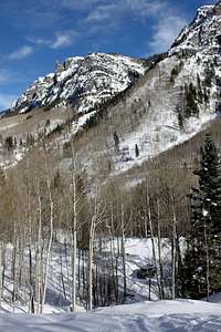
Yankee Boy Basin is a very spectacular alpine basin and provides an access to many peaks frequently photographed and mentioned on SP, e.g. Mount Sneffels, Gilpin Peak, Teakettle Mountain, and Potosi Peak to mention a few.
Getting There
Drive on Ouray Main Street = U.S. 550 road south, and turn just past the first switchback on the well signed Imogene Pass/Camp Bird Road (# 361). This road goes through the Ice Park. It is a well maintained dirt road, snow plowed in the winter for the first 4.5 miles to the Senator Gulch area. It is better to have a 4WD vehicle, but if you have snow chains you can drive to the parking lot at the Senator Gulch even with a low clearance car. The road is exposed and can get very icy.The parking lot is not very big. It can accommodate about 15 cars, and I have seen it full on busy winter weekends.
 Ouray Main Street Ouray Main Street | 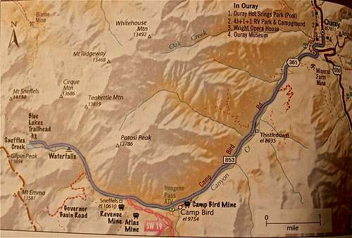 Map of the Camp Bird Road Map of the Camp Bird Road |  Heading for the hills Heading for the hills |
After a snow melt, two-wheel-drive can take you up to about 7 miles high up, four-wheel-drive vehicles can go all the way to the end at Yankee Boy Basin. The road gets rougher higher up.
 |  |  |  |
Ice Climbing
The Camp Bird Area is one of the most popular destinations in the region. There are many ice climbs located just off the road, and within a few minutes of an easy walk on a snow covered road. Some climbs are located across the creek, and those require some scrambling and a little longer approach.The Camp Bird Road is a nice place to visit even for non climbers. You can hike along the route and take photos of different routes and admire skills of climbers. You may be lucky and run into Steve House, who just moved to this area, and often plays here. Weekends are guaranteed that you will find someone battling on the icefalls, or dry tooling on canyon's steep walls.
The best guide book describing this area is Colorado Ice by Jack Roberts. You can pick up this book at Ouray Mountain Sports as well as your ice climbing gear. They are renting ice tools and crampons, and are a very good resource for all climbing in the area.
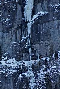
| The Ribbon |  Climbers on Ribbon Climbers on Ribbon | WI4 | This climb is located just across the parking at Senator Gulch, a striking line of ice that splits the cliff across the canyon. It is among the top 10 ice climbs in this area. Drop through the trees into the main drainage and head toward the climb. Hike time takes about 45 min. Death route - very exposed to avalanches. Descent: rappel the route using bolts stations left of ice.The Ribbon does not form every year, 2009 was a bad year for this ice climb. (2010 was good, 2011 and 2012 were bad, and 2013 season started great, good conditions).SP route description for The Ribbon |
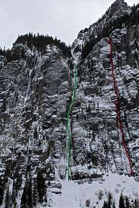 Birdbrain is red Birdbrain is red | WI5M6 | This is the narrow gully/chimney system to the right of the Ribbon. There is possible avalanche danger on approach slopes. Hike time is about 60 min. Birdbrain is a classic San Juan testpiece. For a long time, climbers would wait and wait, sometimes for several years, for the "right" conditions to arrive. As mixed climbing became more popular, this route gets climbed more. The climb usually takes six to eight pitches. The climbing in the first couple of pitches tends to be easier WI4 with some mixed climbing, depending on conditions. Generally, the fourth and fifth pitch comprise the crux and involve difficult mixed climbing with poor protection. Bring more rock than ice gear. Descent: Rappel the route via trees on the left side of the climb or from fixed belay anchors (not placed at each belay station). SP route description | |
 Off Limits Off Limits | WI4/5 | This climb is supposedly OFF limits, there are no trespassing signs. However, I am mentioning this because this climb is located right next to the parking area, and I know climbers who climbed it, and have seen climbers trespassing over there many times. It is a 1 pitch climb, about 40 meters long. And a pretty popular one. Local tend to climb in in the mid week - less likely to be caught by the owner. Senator GulchThere are two small ice falls below this one - Lower Senator Gulch, which are practically next to a parking lot. The lower ice falls are easy WI2, and are ok for climbing. Ouray high school sometimes takes their students up there. An excellent place to learn your first ice lead. Or you can set up a top rope on these lower icefalls, one leads to the top of the road above. | |
 Dry Tooling Dry Tooling | M5-10WI3-5 | The Skylight area is second only to the Ouray Ice Park in popularity due to a concentration of high-quality climbs and ease of access. Avalanche danger can be extreme here, again always check conditions before venturing out. Most of the climbs face east to southeast and form from snowmelt; they tend to get thicker as the season progresses. Several days may be spent here sampling excellent climbing. Some of the climbs are: Poser's Lounge, Just Another Duncan Route, Sans Nom, Sven's Route, Ass in Space, Road Warrior, The Cleft, The Skylight, Killer Pillar, Choppo's Chimney, Chopped Suey, Another Climb, Tourist Trap, Fractured Fairytales, Slip Slidin' Away, Heart of Darkness, Slippery When Wet, AC/DC, Chock Up Another One, Chockstone Chimney etc. I am hoping to be writing more detailed route descriptions as I get to climb these icefalls.There is plenty of ice at Skylight area, don't get discouraged by looking at the Dry Tooling photo | |
 Midsection Midsection | WI6+M7 | The climb is located above the Skylight area, it is a difficult route. You have to drop down the side of the road and cross the stream below in the canyon. Hiking time is about 45 minutes. There are a couple of variation to this climb, but all are difficult. The first pitch ascends a steep, smooth slab with a very poor protection. Pitch 2 ascends a pillar of thin ice, and at higher sections you are forced to climb on rock. Conditions on this pitch vary from year to year. The 3rd pitch is on ice, very steep. |
The Original Page by CClaude
This paragraph below lists some of the climbs in the Skylight area.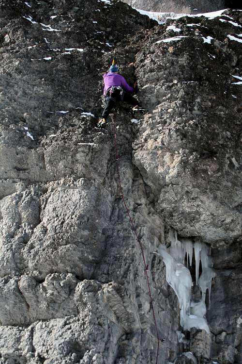 Easy Mixed Climb at Camp Bird
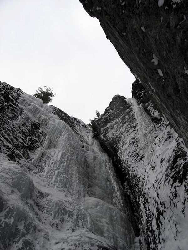 Choppos Chimney
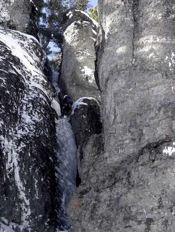 Slippery When Wet
 Chockstone Chimney Chockstone Chimney |  Skylight Skylight |  Skylight detail Skylight detail |  Slip Slidin' Away Slip Slidin' Away |  Slippery When Wet Slippery When Wet |  Choppos Chimney Choppos Chimney |
Essential Gear

Broken Crampon
Good and hopefully warm boots, crampons (not broken ones!), and ice tools.
Leashes for ice tools are better in the wilderness. Most climbers in the ice park climb leash less, but the real ice, and especially a multi-pitch route is another story. I had an incident that while following on a multi pitch route, I slipped, left my ice tools lodged in the ice, and with the rope elongation I dropped a couple of feet down. I was not able to reach my tools! So, now I remember, always to use leash on my tools when climbing outside the park.
An assortment of ice screws of different lengths.
Slings, rappel back up (some have bolts for descent, and some have anchors around trees - but always check its condition, could be a few years old).
Rock gear if you are planning to climb mixed routes. Some of the dry tooling routes in Skylight area are bolted, so at least quickdraws.
Rope - most climbs require only 60 meter one (70 meter rope is popular in the Ice Park, so you can belay across the stream, and not stand right below your climbing partner).
Harness, and warm clothes with many layers. Ice climbing can get very cold. I love my Arcteryx pants and underwear - knee pads, very warm and a zipper over midline letting me use the bathroom even with the harness on.
Red Tape
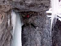
Photo by Ice Man Jerry Van

Photo by Ice Man Jerry Van
Camp Bird Road access is free, as well as parking at the Senator Gulch, and ice climbing.
Locals tend to buy a Membership to the Ouray Ice Park. Climbing at the Ice Park is free, and the membership helps with the maintenance of the park, water delivery system etc.
Always check Avalanche Conditions before venturing out into the backcountry.
Senator Gulch ice fall is currently off limits, no trespassing sign. I have seen many people climbing it, but if you get caught (unlikely) by sheriff, you will be punished.
Winter Mountaineering
Camp Bird Road provides the easiest access the the Yankee Boy and Governor Basin. Yankee Boy Basin is very popular in the summer, there are number of peaks surrounding this beautiful alpine scenery. You can drive to over 12,500 feet in the summer, but the winter is a different story. There is solitude, and most people do not venture more than 1 mile above the Senator Gulch parking are. The approach to the Yankee Boy basin takes about 2 days on snowshoes or skis depending on the snow. You follow the road, and always check for avalanche conditions. Snowshoeing Snowshoeing |  Camping out Camping out |  Pulling the sled Pulling the sled |  Climbing Mt. Emma Climbing Mt. Emma | 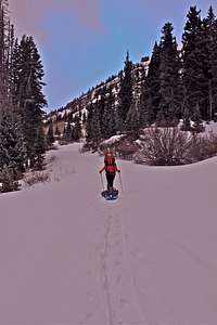 Sunset Sunset |
| Peak | Elevation | Note |
| Mount Sneffels | 14,156 ft / 4315 m | The only fourteener in this basin with several interesting routes. |
| Gilpin Peak | 13,694 ft / 4174 m | Gilpin Peak is directly south from Sneffels, not very commonly climbed. You can climb it directly from the Yankee Boy Basin, or from Blue Lake Pass. |
| Kismet | 13,694 ft / 4174 m | Kismet is the cluster of points directly north of Wright's Lake and 0.5 miles east-southeast of Sneffels. You may need rope for the last section. |
| Cirque Mountain | 13,686 ft / 4171 m | Cirque Mountain is 1.2 miles east of Mount Sneffels on the continuing range crest. It has a gentle west ridge. It it best approached from the Dyke Col between Kismet and Cirque. |
| Teakettle Mountain | 13,819 ft / 4212 m | Teakettle Mountain continues the range summits east of Sneffels. The standard approach starts around 11,400 ft (=the toilet trailhead). The scramble is on a very loose rock, but the reward of standing in the teakettle handle is amazing. The final scramble sometimes requires rope (low 5th class). |
| Coffeepot = S1 | 13.568 ft / 4136 m | Usually climbed together with the Teakettle Mountain. It is a little protruding knob. Some people bag Teakettle, Coffeepot and Potosi all in one day - summer, during the winter very hard. |
| Potosi Peak | 13,786 ft / 4202 m | Potosi Peak is the southeast termination of the Sneffels Range crest. Potosi has a formidable looking summit block, and is more easily climbed from the east, where there is a break in the cliffs. |
| Stony Mountain | 12,698 ft / 3870 m | Stony Mountain is the little peak, but looks very impressive from the dirt road, that splits Governor Basin off from Yankee Boy basin. It is a fun scramble up its west ridge. |
| Mount Emma | 13,581 ft / 4139 m | Mount Emma is climbed to the northwest from upper Governor Basin or southwest from the jeep road in Yankee Boy Basin. It form the north end of Saint Sophia Ridge. |
| Mendota Peak | 13,275 ft | Mendota Peak forms the south termination of Saint Sophia Ridge. You have to climb on the Telluride side of the ridge to reach its summit. |
Weehawken Trail
Weehawken Trail # 206 is a nice trail along the lower Camp Bird Road.Traihead just off the Camp Bird Road, past the bridge, 2.7 miles from the highway 550 and 0.7 miles beyond the second bridge.
Desriptions The first mile of this trail climbs through aspen groves and open meadows. The views of Mt. Hayden are beautiful. The trail splits after 1.3 miles. The right fork is the Alpine Mine Trail. Take the left fork for the Weehawken Trail, which takes you up and down on a narrow trail into the Weehawken valley. The effort taken on this trail will reward you with views of waterfalls, alpine meadows, flowers in the summer and canyon walls of gray volcanic rock. The trail reaches an open avalanche basin at 2.7 miles, then enters forest and follows a gorge where cascades may be seen. The maintained trail ends at the boulder-strewn Weehawken Creek bed, at 3.1 miles.
Weehawken Trail is also popular with backcountry skiers. Avalanche danger is relatively low there, and you can ice climb in the morning and ski in the afternoon - that is what I do.
 |  |  |  |  |
 |  |  |  |  |
Bouldering
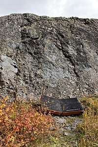
Bouldering is obviously not a winter activity, and since the boulders are above 9000 feet high, the conditions may be different from climbing down in the town. Boulders are type of volcanic ash called welded tuff. The area is largely undeveloped. Expect to do some cleaning on many of the problems.Boulders are past the Skylight Climbing Area - pretty obvious group of boulders with a pull out on your right.
 |  |  |  |  |
Camp Bird Road in the summer
The Camp Bird Road is very popular in the summer. As mentioned above it provides access to the Yankee Boy Basin, where a number of 13ers and Mount Sneffel, one of the Colorado fourteeners are located.You can also turn onto Imogene pass road and drive on a rough 4WD road to Telluride.
 Exposed Road Exposed Road | 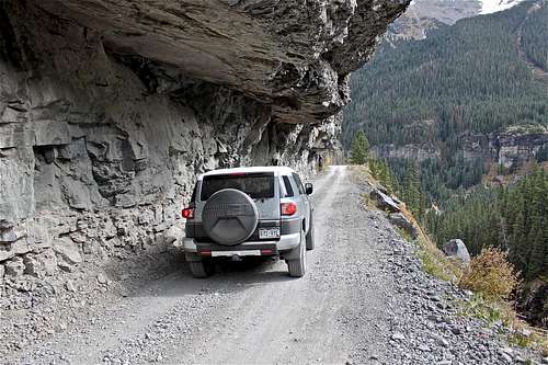 Dramatic section of the road Dramatic section of the road |  Mountain biking Mountain biking |
Weather
