
|
|
Mountain/Rock |
|---|---|
|
|
37.98660°N / 107.7924°W |
|
|
Ouray & San Miguel |
|
|
Hiking, Mountaineering, Ice Climbing, Mixed |
|
|
Spring, Summer, Fall, Winter |
|
|
13694 ft / 4174 m |
|
|
Gilpin Peak Overview
 Gilpin Peak
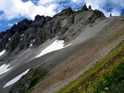
Gilpin Peak is a major summit in the Sneffels Range section of Colorado's spectacular San Juan Mountains. With its excellent access, you can easily climb this peak in a short morning from a 'base camp' in Ouray. Gilpin rests at the spot where the serpentine Sneffels Range splits in two to accommodate the great basins between Telluride and Ouray, namely Imogene, Governor and, most famously, Yankee Boy Basin. These basins are well-known for the abundant wildflowers that carpet the tundra there during the summer months. Gilpin has a rugged quartet of subpeaks, known locally as The Block Tops, which lie to the west along the ridge that leads to Dallas Peak. The easternmost Block Top takes on the appearance of a teapot from some perspectives, so Teakettle Mountain isn't the only place in the area where you can view a culinary silhouette! The brilliant colors and ragged spires of the rock in the Sneffels range are due to its variety of igneous sources, including magma and ash. Gilpin lies due south of Mount Sneffels, and most climbers of that delightful 14er have no doubt cast an awestruck eye toward Gilpin's beautiful northeast face. Boringly, Gilpin is named for a politician. William Gilpin was the territorial governor of Colorado for two years in the 1860's, and he's the same person for whom Gilpin County is named.
The peak is Colorado's 149th tallest (sixth tallest in the Sneffels Range), and it offers a variety of routes from Yankee Boy Basin. The standard route up Gilpin ascends its Northwest ridge from Blue Lakes Pass, and it's a straightforward scree slog that takes you through some beautiful terrain. There's also the precarious Southeast Ridge route -- the route that's described in Garratt & Martin's book -- which makes the most sense only if you're trying to combine a climb of Gilpin with its neighbor Mount Emma. I've only heard bad things about this route, but it may serve as some good training for the Sneffels Range's more difficult peaks. Lastly, there's the steep North Couloir that splits Gilpin's northeast face. I have no beta on this route, but the summit register indicated that more than one party has climbed it in recent years, reporting icy conditions.
Getting There
Gilpin Peak is most easily accessed from Yankee Boy Basin. To reach Yankee Boy Basin, head south from Ouray on US-550. Just past the first major switchback, turn right onto CR-361. There are signs here for Box Canyon Falls and some other attractions. The road has a few shelf sections -- including one part that was cut right into the cliff! -- but a two-wheel-drive vehicle can make it at least to Camp Bird. With a high clearance vehicle, proceed into Yankee Boy Basin as far as you are comfortable (with a 4WD you can obviously go the furthest). There's parking available all along the road with especially good parking at the various campsites, the Sneffels townsite, the turnoff for Governor Basin, at 11,400' next to an outhouse, and beyond.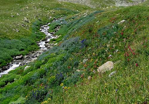 Sneffels Creek, Yankee Boy Basin
Red Tape
Gilpin Peak is located in San Juan National Forest. Contacting the managing agencies (see 'Mountain Conditions') is the surest way to get up-to-date information. There are no fees in Yankee Boy Basin unless you decide to camp there.Leave No Trace suggests you observe these principles when traveling and camping in all public lands:
1. Plan Ahead and Prepare
2. Travel and Camp on Durable Surfaces
3. Dispose of Waste Properly
4. Leave What You Find
5. Minimize Campfire Impacts
6. Respect Wildlife
7. Be Considerate of Other Visitors
When To Climb
The easiest time to climb Gilpin Peak is June-September, but this varies year-to-year with the snowpack. Access to Yankee Boy Basin remains pretty good year-round, so winter-season ascents are certainly not out of the question.Camping
Camping is permitted in Yankee Boy Basin via a permit system in designated sites.Mountain Conditions
The Ouray Ranger District (970-240-5300) of the San Juan National Forest is your best bet for gathering information on current snow conditions and other information. Other resources include Ouray Mountain Sports and Ouray Mountain Rescue.For weather information, the National Weather Service is a good place to start:
Gilpin Peak experimental point forecast