
-
 21490 Hits
-
 94.02% Score
-
 45 Votes
|
|
Area/Range |
|---|---|
|
|
47.07760°N / 9.73380°E |
|
|
Hiking, Mountaineering, Trad Climbing, Sport Climbing, Aid Climbing, Big Wall, Skiing |
|
|
Summer, Fall, Winter |
|
|
9724 ft / 2964 m |
|
|
1 - Overview
 Sporaturm (by herbie) Sporaturm (by herbie) |
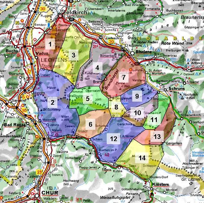
The Rätikon Range is located in the border region between three of the smallest European countries: Austria, Switzerland and Liechtenstein. Liechtenstein, in fact, is completely contained in the range. While generally qualified as belonging to the eastern central Alps from a geological point of view the Rätikon mountains have much more in common with the northern limestone Alps, such as their northern neighbours in Bregenzer Wald and Lechquellengebirge. One specific type of limestone, Sulzfluhkalk, has obtained its name from one of the most important mountains of the range. The range is the westernmost range of the eastern Alps (see below).
Basically, Rätikon consists of a long and winding main ridge, which starts in the north-west of the group and end in its south-east. The border between Liechtenstein and Austria follows the ridge in the north while the border between Switzerland and Austria follows close in the south. Along this ridge you will find the main mountains of the Group, Schsaplana, Drusenfluh, Sulzfluh, Madrisa, all well below 3000m. To its side there are quite a number of side ridges, few in the south and many impressive ones in the north. Overall, the range gives the impression so typical of the Limestone Alps – smooth green meadows in the valleys out of which very impressive limestone towers rise.
Rätikon is bounded by three sides by profound valleys. To the west there is the young Rhine River which separates the range from The Glarn and Appenzell Alps and which also serves as the geographical boundary between Eastern Alps and Western Alps. The southern boundary is Prättigau, the valley of the Landquart River, ending at Klosters. The northern boundary is Montafon and Walgau, in other words the valley of the Ill River which joins the Rhine River near Feldkirch. In the east Schlappiner Joch is the ultimate boundary, a pass which connects the Schlappintal Valley in the south with the Gargellental Valley in the north. It also separates Rätikon from the Silvretta Group.
As a hiking ground the range stands in the shadow of its taller neighbours, especially Silvretta in the south east. There is a 9 day trekking trail, the Rätikon Tour and there is one via Ferrata (Klettersteig). Then, there is beautiful Lünersee, a large lake right underneath the central mountains of the group, as beautiful a lookout spot as you may wish.
 Schesaplana (by Mathias Zehring) Schesaplana (by Mathias Zehring) |
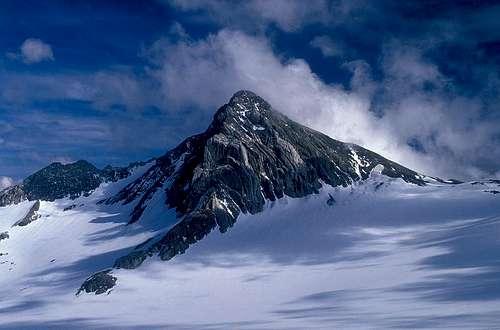
However, in terms of climbing there are only few alpine groups which match its importance. The highest mountain of Rätikon, 2965m high Schesaplana, was already climbed back in the early 17th century by David Pappus, Christa Barball and Claus Manall, all of them from the eastern Vorarlberg (Austrian) side of the range. The other important peaks followed suit so that around 1875 the last of them had been climbed.
In the 20th century, notably in the late 20s and 30s, modern climbing started in the Drusenfluh area when the south face of the mountain and two of the south-eastern towers – Drusentürme (Drei Türme) were climbed. In the 50s more routes followed on the towers, on Sulzfluh and on neighbouring Schijenfluh. But all these routes where laid to rest after the first routes were established on the south-west faces of the seven Kirchlispitzen.
The Kirchlispitzen, seven peaks, following very close to each other on the ridge between Schesaplana and Drusenfluh, offer profound south faces with superb slab climbing. Vital Eggenberger and U. Hew established the first route on any of the Kirchlispitzen in 1974 and from then on one ultra-difficult route followed another. Protagonists were Martin Scheel and Beat Kammerlander. The routes that they established read like a who-is-who of routes: Amarcord (9-), Accacia (9+), Unendliche Geschichte (10+), Silbergeier (10+), WoGü (11-). Apart from these ultra-hard routes a lot of shorter and/or easier ones exist, most of them on Schweizereck (a rock on the other side of the Schweizer Tor Pass from 7. Kirchlispitze) and Drusenfluh. In the External Links section of this page you will be directed to several climbing sites of the area.
2 - Rätikon on SP
 |
3 - Drei-Schwestern-Chain
The Drei-Schwestern-Chain is the north-westernmost group of Rätikon. It is a single ridge, located between the Rhine River Valley to the west and Saminatal Valley to the east. One third of the Liechtenstein border with Austria runs across this chain, which culminates in Garsellakopf (2105m) in its centre. The chain received its name from the three-headed peak of Drei Schwestern, which is widely visible, especially from the west.- Frastanzer Sand (1634m)
- Sarojahöhe (1559m)
- Drei Schwestern (2053m)
- Garsellakopf (2105m)
- Garsellatürme (1848m)
- Kuegrat (2123m)
- Gafleispitz (2000m)
- Alpspitz (1942m)
- Chemi (1937m)
- Helwangspitz (2000m)
4 - Naafkopf-Falknis-Chain
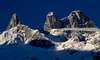
 Naafkopf-Falknis Chain from Buchs (by McCannster)
The Naafkopf-Falknis-Chain constitutes the southern and eastern border of Liechtenstein. The subgroup – which is the largest one of Rätikon in terms of area – encompasses several other ridges, mainly in the north of the main ridge. At Naafkopf the borders of the three countries Liechtenstein, Switzerland and Austria join. In the west the subrgroup is bounded by the Rhine River, in the south by the Landquart River. The eastern boundary is at Barthümeljoch, where the Trieserbach Valley from the south joins the Gamperdona Valley from the north. The northern boundary is at Sareiserjoch, where the Malbrun Valley joins the Gamperdona Valley.
- Guschner Gir (1581m)
- Wörnerhorn (1713m)
- Mittagspitz (1857m)
- Mittlerspitz (1899m)
- Rotspitz (2127m)
- Mazorahöhi (2045m)
- Falknishorn (2451m)
- Falknis (2562m)
![]()
- Vorder Grauspitz (2566m)
![]()
- Hinter Grauspitz (2599m)
![]()
- Naafkopf (2571m)
![]()
- Augstenberg (2359m)
![]()
- Spitz (2186m)
4.2 - North-Western Side Ridge
- Plasteikopf (2356m)
- Rappastein (2222m)
![]()
- Koraspitz (1927m)
- Goldlochspitz (2110m)
- Kolme (1993m)
- Heubüal (1936m)
- Chrüppel (1707m)
4.3 - North-Eastern Side Ridge
- Silberhorn (2150m)
- Tälihöhi (2056m)
- Nospitz (2091m)
- Kirchlespitz (1819m)
4.4 - South Ridges
- Tannkopf (1864m)
- Mazorakopf (2164m)
- Schwarzhorn (2346m)
![]()
- Glegghorn (2447m)
- Vilan (2375m)
- Larnoz (1717m)
4.1 - Main Ridge


5 - Galina-Group
Named after ist highest summit, Galinakopf, this group is a jumble of several (mostly) short ridges. It is located between Gamperdonatal Valley to the east and the Saminatal Valley to the west. Up north both valleys join the broad Montafon Valley, where most of the habitation (and accommodation) can be found. The southern border is formed by the Rätikon Main Ridge. The border between Liechtenstein and Austria follows this ridge. To the south-west of the group, the only Liechtennstein village of the group can be found: Malbrun.- Gamsgrat (2246m)
- Ochsenkopf (2286m)
- Scheienkopf (2159m)
- Wurmtalkopf (2008m)
- Galinakopf (2198m)
- Hohe Köpfe (2066m)
- Haarkopf (1638m)
- Goppaschrofen (1791m)
- Gurtisspitze (1778m)
5.2 – Schönberg Group
- Stachlerkopf (2084m)
- Schönberg (2104m)
5.3 - Älpele Ridge
- Innerer Älpelekopf (2122m)
- Äußerer Älpelekopf (2063m)
- Jochgrat (1937m)
- Eckskopf (1563m)
5.4 - Hachlakamm Ridge
- Zigerbergkopf (2051m)
- Hachlaköpfe (1731m)
- Söllerseck (1198m)
5.5 - Lohnspitz Ridge
- Lohnspitz (1758m)
- Gampberg (1708m)
- Brandlekopf (1481m)
5.1 - Main Ridge
6 - Fundelkopf-Group
The Fundelkopf Group, also named after its highest summit, is one of the smaller groups of Rätikon. It is located between Gamperdonatal Valley, Brandner Tal (west and east) and Montafon to the north. Its southern boundary is Oberzalimscharte, which separates it from the Montafon main ridge. In terms of tourism, the Fundelkopf Group is one of the hotspots of the range as Brand and the neighbouring villages developed quite a number of ski runs here. Especially the lower mountains in the east and north are affected.- Fundelkopf (2401m)
- Kleiner Fundel (2104m)
- Tuklar (2318m)
- Alpilakopf (2150m)
- Zwölferkopf (1644m)
- Spießeck (1614m)
- Schillerkopf (2006m)
![]()
- Mondspitze (1967m)
![]()
- Klamperschrofen (1755m)
- Schwarzkopf (1753m)
6.1 - Loischkopf Ridge
- Taleu (1748m)
- Loischkopf (1805m)
![]()
- Mottakopf (1221m)
6.1 - Main Ridge


7 - Schesaplana-Group and Zalimkamm
 Schesaplana (by Cyrill)
Schesaplana is the highest mountain of Rätikon and consequently the surrounding subgroup is among the most important ones of the range. It is a small group, however, consisting of a short part of the Rätikon main ridge with several short side ridges. The eastern and western boundaries are two saddles, Gafalljoch and Barthümeljoch. The group contains Rätikon’s sole remaining glacier: Brandner Gletscher. The border between Austria and Switzerland runs across the main ridge here.
- Augstenberg (Tschingel, 2541m)
- Hornspitze (2537m)
- Saruelkopf (2841m)
- Schesaplana (2965m)
![]()
- Totalpköpfe (2587m, 2556m)
- Kanzelköpfe (2437m)
- Lüneregg (2297m)
7.2 - Zalimkamm
- Rote Wand (2050m)
- Zalimwände (1950m)
- Strahleck (2068m)
- Galamant (1730m)
- Planüeler Kopf (2859m)
- Pfannenknechtle (2234m)
- Otterkirchle (1964m)
- Kämmerlischrofen (2132m)
- Blankuskopf (2334m)
- Windeggerspitze (2331m)
7.3 - Wildbergkamm
- Wildberg (2788m)
- Mottakopf (2176m)
![]()
- Mittelberg (1493m)
7.4 - Zirmenkopf Kamm
- Felsenkopf (2835m)
- Zirmenkopf (2806m)
- Seekopf (2698m)
7.1 - Main Ridge

8 - Girenspitz-Sassauna-Ridge
Similar to the Fundelkopf Group, the Girenspitz / Sasauna Group does not touch the Rätikon main ridge. It is located on Swiss ground completely between Schindsbachtal Valley in the west and Schraubachtal Valley in the east. To the south the boundary is Prättigau and the Landquart River, while to the north Golrosa Saddle separates the group from the main ridge. Girenspitz and Sasauna are the only two important summits of the group, which also sports a few ski lifts in its southernmost area.- Schafbüel (2027m)
- Girenspitz (2394m)
- Drosbüel (2002m)
- Waldbüel (1901m)
8.2 - Sassaunakamm
- Tüff Sagettis (2273m)
- Lägend Sagettis (2169m)
- Picardichöpf (2076m)
- Pfärvi (2306m)
- Glattberg (1820m)
- Sassauna (2308m)
8.1 - Büelkamm
9 - Zimba Group and Vandanser-Wand
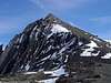
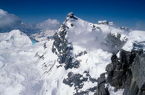
 Zimba Group behind Kleine Sulzfluh (by Mathias Zehring)
Zimba easily is the most impressive and outstanding mountain of Rätikon. Dubbed the "Rätikon Matterhorn" thanks to its steep pyramid-like form it dominates the ridges between Brand and Vandans. This Group is located between Brandner Tal Valley and Vandanser Tal Valley with Montafon as the northern boundary. The southern boundary is Saulajoch Saddle, which separates it from the Kirchlispitzen Group.
- Saulakopf (2517m)
![]()
- Brandner Mittagspitze (2557m)
![]()
- Zimba (2643m)
![]()
- Steintälikopf (2443m)
- Großer Valkastiel (2449m)
- Kleiner Valkastiel (2233m)
- Mittagspitze (2107m)
- Gulmkopf (1781m)
- Rosskopf (2080m)
- Steinwandeck (1996m)
9.2 - Northern Ridges
- Gottvaterspitze (2438m)
- Schafgufel (Dreispitz) (2351m)
- Zwölferkopf (2271m)
- Kannerberg (2099m)
- Valbonakopf (174m)
- Tantermauses (1821m)
- Matätschrüfi (1580m)
9.3 - Southern Ridge
- Wildberg (2372m)
- Sarotlahörner (2192m)
- Wasenspitze (2009m)
9.1 - Main Ridge


10 - Kirchlispitzen-Group
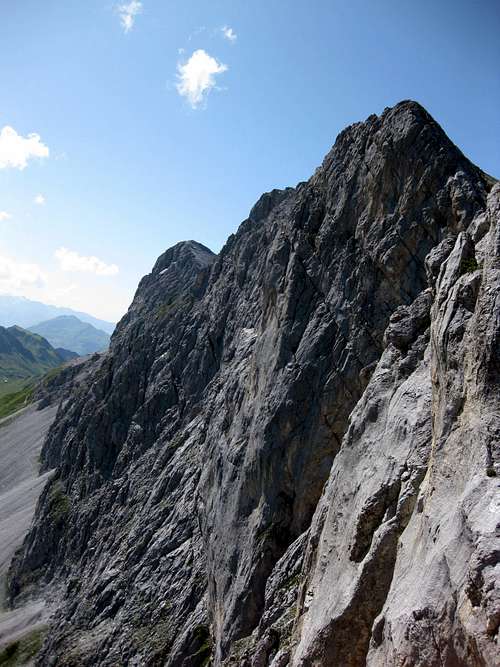 Kirchlispitzen south faces (by Jurgen Mesman)
Easily the smallest subgroup of Rätikon the seven summits of Kirchlispitzen are among the most important climbing walls of the Alps. They stretch on the Rätikon main ridge (on the Swiss - Austrian border) between Gafalljoch and Schweizer Tor. A popular hiking trail circles the group, starting at Lünersee, a large mountain lake to the north-west of the group. Northern and southern boundaries are Saulajoch Saddle and Golrosa Saddle respectively.
- Kirchlispitzen (2551m)
![]()
- Rossberg (2452m)
- Zalundakopf (2487m)
- Freschluakopf (2314m)
- Schafgafall (2414m)
![]()
- Gipsköpfle (1975m)

11 - Golmer Grat and Zerneuer Grat
Another very small group (not in terms of area but in terms of summits) is located to the north-east of Kirchlispitzen between Vandanser Tal Valley and Gauertal Valley. It is separated by Öfapass Saddle and Schweizer Tor from the Rätikon main ridge and consists of a handfull of mountains. It is quite popular among hikers, tank to the short access routes. Golmer Joch is the ski mountain of Vandans and thus nut the most beautiful of destinations.- Vandans (2345m)
- Kreuzspitze (2353m)
- Geißspitze (2334m)
- Wilder Man (2291m)
- Latschätzkopf (2219m)
- Golmer Joch (2124m)
12 - Drusenfluh-Group
 The Drusenfluh Group seen from the Swiss side (by Mathias Zehring)
Back to the main ridge and tot he border between Switzerland and Austria. Between Schweizer Tor and Drusentor, two saddles on the ridge, you can find some of the most important mountains of the range. Again, the group consists only of half a dozen named summits but Drusenfluh and Drei Türme are among the best known mountains of the whole range. Öfapass is the saddle which sparates the group from Zerneuer Grat.
- Schweizereck
- Drusenfluh (2827m)
![]()
- Eisjöchle (2638m)
- Drei Türme
![]()
- Kleiner Drusenturm (2754m)
- Mittlerer Drusenturm (2782m)
- Großer Drusenturm (2830m)
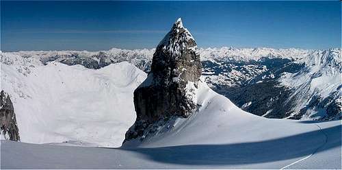
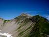
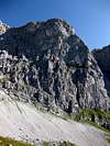
- Sporaturm (2489m)
- Gamsfreiheit (2445m)

13 - Sulzfluh-Group
 Sulzfluh seen from Weißplatte(by Mathias Zehring)
To the east of the Drusenfluh Group, the next important mountain of Rätikon waits for description: Sulzfluh. Its group is part of the Rätikon Main Ridge, which runs a loop here. In addition the Schwarzhorn Ridge to the north of Sulzfluh is also considered as belonging to the group. The western limit is Drusentor Saddle, the eastern one Plaseggenpass. To the north the group ends with Tschagunser Mittagspitze, high above the upper Montafon Valley.


14 - Schafberg-Group
South of Sulzfluh there is a large group in terms of area but small in terms of mountains. Five smaller summits make out the Schafberg Group, which lies above the villages St. Antönien and Partnun. It is bounded by Schraubbachtal Valley in the west and Schanielatal Valley to the east. Southern boundary is Prättigau the northern boundary the Carschinafurgga Saddle.- Schafberg (2456m)
- Girenspitz (2369m)
- Chüenihorn (2412m)
- Chrüx (2196m)
- Alpbühel (2021m)
15 - Gweil-Sarotla-Crest
The Ridge between Gweilspitze in the north and Schollberg in the south, which in its southern part belongs to the Rätikon Main Ridge, is the easternmost subgroup of Rätikon. Its north ridge is separated from the main ridge and forms the backdrop of the village of St. Gallenkirch. The southern part of the group joins the main ridge at Plasseggenpass and ends at St. Antönier Joch (saddle). The most important summits are the Sarotlaspitzen.- Sarotlaspitzen (2563m, 2545m)
- Innerplatinak (2505m)
- Außerplatinak (2416m)
- Rutihorn (2348m)
- Tilsuna Seehorn (2342m)
- Außergweilkopf (2406m)
- Gweilspitze (2187m)
- Alpilakopf (2255m)
- Motadenser Kopf (2041m)
15.1 - South Ridge
- Röbispitzen (2466m)
- Borstkopf (2304m)
- Rotspitze (2517m)
- Rongspitze (2534m)
- Riedkopf (2552m)
- Schollberg (2570m)
15.2 - North Ridge
16 - Madrisa-Group
The southernmost subgroup of Rätikon is the Madrisa Group. Beyond Madrisa, its highest summit, the Rätikon main ridge comes to an end at Schlappiner Joch, the saddle which separates Rätikon from Silvretta. In general the group is part of said main ridge (south of St. Antöönier Joch) but it also contains a jumble of side ridges, forming a large cirque on the southern (Swiss) side of the mountain. There are two summits, named Madrisa, one on the Austrian side (2770m), one on the Swiss side of the border (2826m).- Gämpiflue (2390m)
- Gargellener Köpfe (2482m, 2506m, 2482m, 2320m)
- Frygebirg (2741)
- Madrisa (Au, 2770m)
- Gandataler Köpfe (2732m, 2653m, 2497m)
- Madrisahorn (2809m)
- Madrisa (Ch, 2826m)
- Sant Juggem (2542m)
- Barnett (2378m)
16.2 - North-Western Ridge
- Plattenflue (2648m)
- Hasenflüeli (2341m)
![]()
- Geistschuggen (2295m)
- Ammaflue (2217m)
- Eggberg (2202m)
![]()
16.3 - South-Western Ridge
- Rätschenhorn (2703m)
![]()
- Nollenchöpf (2285m)
- Jägglisch Horn (2290m)
- Saaser Calanda (2556m)
- Bockhorn (2351m)
- Geisshorn (2270m)
16.1 - Main Ridge

17 - Getting There
Access to the group is a not difficult but rather remote. The following itineraries are from the closest international airports at Innsbruck, Stuttgart and Zürich.- From Innsbruck
Simply take motorway A12/E60 west until you reach the exits Bludenz or Feldkirch. For the eastern part of the group follow the Ill Valley southwards from Bludenz, for the western and southern parts leave at Feldkirch and take B191 to Liechtenstein or A13 southward to Bad Ragaz.
- From Stuttgart
Take Motorway A8 east until you reach Ulm. There turn onto A7 south. At Memmingen leave A7 for A96, direction Bregenz. In Austria the motorway is called A14 and leads to Feldkirch. Here either cross over to Liechtenstein for the western and southern parts of Rätikon or stay on A14 until you reach Bludenz for the eastern part.
- From Zürich
From Zürich take motorway A1 east to Bregenz where you cross the border into Austria. Take A14 south, which will lead you to Feldkirch and Bludenz.
18 - Red Tape
There are two Natural preserves, one in the Austrian part, one in the Swiss part of the range. The Austrian preserve is Naturschutzgebiet Gamperdonatal while the Swis one is Naturschutzgebiet Plasseggen-Schijenflue. Here the usual restrictions apply.19 - Mountain Huts and Refuges
| Refuge / Hut | Height | Summer | Winter | Tel. | Thumbnails |
| Voralberg | |||||
| Douglashütte | 1976m | beg June – mid Oct | winter room | +43/5559/206 | |
| Feldkirchner Hütte | 1204m | beg May – mid Oct | beg Nov – mid April | +43/5522/77979 | |
| Haus Matschwitz | 1500m | mid June – mid Oct | Christmas - Easter | +43/5556/73700 | |
| Heinrich-Hueter-Hütte | 1766m | mid June – mid Oct | winter room | +43/5556/76570 | |
| Lindauer Hütte | 1744m | beg June – mid Oct | Christmas / Jan 6th, March | +43/664/5033456 |  |
| Madrisahütte | 1660m | all summer | all winter | +43/6283/225244 | |
| Mannheimer Hütte | 2679m | beg June – mid Sept | winter room | +43/664/3524768 | |
| Oberzalimhütte | 1889m | end June – end Sept | mid March - mid April | +43/664/1229305 | |
| Sarotlahütte | 1611m | mid June – beg Oct | winter room | +43/664/9652995 | |
| Schwabenhaus | 1198m | all summer | all winter | +43/5552/65686 | |
| Tilisunahütte | 2211m | mid June – mid Oct | winter room | +43/664/1107969 |  |
| Totalphütte | 2385m | beg June – mid Oct | winter room | +43/664/2400260 |  |
| Alpengasthof Gamperdona | 1370m | beg June – mid Oct | closed | +43/5525/63200 | |
| Liechtenstein | |||||
| Gafadurahütte | 1428m | mid May – mid Oct | closed | +41/79/2601458 | |
| Pfälzer Hütte | 2111m | mid June – end Sept | closed | +423/2633679 | |
| Graubünden | |||||
| Enderlinhütte | 1501m | beg June – end Oct | closed | +41/79/6816129 | |
| Schesaplanahütte | 1908m | mid June – mid Oct | closed | +41/81/3251163 | |
| Carschinahütte | 2236m | mid June – mid Oct | closed | +41/79/4182280 |  |
20 - Accommodation
 Saess pasture (1941m) (by Mathias Zehring)
Each of the towns and villages of the area has a homepage with the possibility to book hotel rooms and apartments. Follow one of the links below.
20.1 –Bodensee – Vorarlberg Region
20.2 – Bludenz Region
20.3 – Montafon
20.4 – Graubünden
20.5 – Liechtenstein
21 - Weather Conditions
In addition to the weather information on the sites you find under accommodation you can look up these sites:22 - Maps & Books
22.1 – Maps
- Digital Maps
- Regular Maps
- Feldkirch-Vaduz
Kompass Map WK 21
1:50.000
ISBN: 3-85491-023-1
- Bludenz-Schruns-Klostertal
Kompass Map WK 32
1:50.000
ISBN: 3-85491-035-5
- Feldkirch-Vaduz
22.2 – Books
- Bündner Alpen, Bd.7, Rätikon
Paul Meinherz
Rother Verlag
ISBN: 3-8590-2099-4
- Bodensee bis Rätikon
Herbert Mayr
Rother Verlag
ISBN: 3-7633-4197-8
- Rätikon
Alpenvereinsführer
Günther Flaig, Walther Flaig
Rother Verlag
ISBN: 3-7633-1236-6
Out of Print
- Kletterführer Rätikon Süd
Mario Luginbühl, Achim Pasold
Panico Alpinverlag
ISBN-10: 3-9268-0738-5
- Kletterführer Rätikon
Vital Eggenberger
SAC-Verlag Schweizer Alpen-Club
# ISBN-10: 3-8590-2086-2