
-
 10417 Hits
-
 79.88% Score
-
 12 Votes
|
|
Area/Range |
|---|---|
|
|
46.21170°N / 10.65540°E |
|
|
Hiking, Mountaineering, Trad Climbing, Sport Climbing, Ice Climbing, Mixed, Scrambling, Skiing |
|
|
Spring, Summer |
|
|
11667 ft / 3556 m |
|
|
intro
Hikers and Climbers are really "strange people" ... in fine weather weekends and during the summer vacations you can see some sites full of people, the meadows host families with playing childern, on certain paths you can see the classic "Indian file", on certain rocky structures, edges, walls, chimney ecc. you can see coloured spots indicating that many climbers are disputing the grips... no, this is a really too pessimistic vision but ... in the Alps there are some ranges, little known, that offer a great variety of amusing "adventures" both for hikers and climbers
one of them is the PRESANELLA GROUP.
Presanella group features
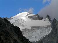
When you hear "Presanella" you normally (of course if you have a minimum knowledge of the Alps) think to a fine mountain, not too high and not too low, with a well visible (from the road) Northern iced wall, very elegant.The ones that have a better knowledge know also the name of the summit W of Presanella, the Cima di Vermiglio whose rocky triangular N wall closes to the W the big wall.
It's really rare finding someone who knows also the names "Cercen" and "Busazza" that are the 2 more main summits belonging to the main watershed between the Tonale valley and the Val Genova.
I think that some small further info could be useful to discover some ranges that are very little known, almost wild, for hikers and some very very fine edges and walls made in a fantastic kind of granite (Tonalite) that looks created just to be climbed ... difficulties range is the widest, you can find there, in some subvalleys, even structrures that have nothing to envy to the ones belonging to the more famous Masino, Gotthard and Val dell'Orco.
As for the "use" of the group we can distinguish 3 parts very different from each other :
This range is rather wild, few and very steep paths, few or no (some small valleys) shelters, big differences in elevation : some very fine rock bulwarks, spurs, edges are the rewards for the ones that dare to enter here: feeling like explorers and "old time climbers"
The range from Tonale Pass toward East, till the big Costone dei Pozzi is very rarely frequented, looking like the opposite (S) side, but with much less difference in elevation - I've never met someone that had climbed one of the tens routes on the N side of Busazza ...
On the contrary the big valley of Stavel (Vermiglio), whose S border is the "wall" of Presanella (Presanella-Cima di Vermiglio) has well marked paths and a really comfortable refuge (Stavel-Denza) ... and this is the range that all have seen and put in their cameras and the most frequented for the ski-mountaneering route and the absolutely classic routes in ice and mixed.
This is the kingdom of hiking but absolutely not to be underestimated - out of the few well marked paths the range can offer tricky and somewhere dangerous passages.
It's really difficult to find, in the whole Alps a group similar to this one.
Getting there
Two main accesses to the group :Boundaries
W - Passo Presena - to the N the Presena valley - to the S the Mandron valley (rifugio Mandron) and the MaroccheN - the Val di Sole - from Passo del Tonale to Dimaro
E - the Val Meledrio and the Val di Campiglio - from Dimaro to Carisolo
S - the Val Genova - from Carisolo up the to rifugio Bedole
the main ridge is the watershed between the Sarca valley (S) and the Noce valley (N)
Main Ridge - W to E summits
passo Cercen - 3022m the only easy door S-N
East of the Cima Giner the ridge breaks in some small subridges bordering small valleys that end with the grassy meadows of the ski area of Madonna di Campiglio, Marilleva and Folgarida
Accesses - from South
from Val Genova - rifugio Bedole :| Conca del Mandrone |
Marocche ridge
| Val Ronchina |
for a photo | sperone della Ronchina - from Cima Presena to S : |
| Val Zigola ending to the Passo dei Segni 2875m on the main ridge between the Presena and the W summit of Busazza Circo del Dosso |
 | here 2 minor spurs, coming down to S from the main ridge, host some small towars (Punta Silvia and Torre Oggioni) sperone di Cercen - from E summit of Busazza to S |
| Val Cercen - starting point from Val Genova is the Rifugio Stella Alpina divided, in the high part, into two subvalleys : |
 | the E border of Val Cercen is the Gabbiolo ridge hosting some very fine rocky summits : |
| Val Gabbiolo - starting point from Val Genova is the Rifugio Stella Alpina very wild ... |
 | between the Gabbiolo Ridge and the Nardis ridge that is the most important one in the S side of the group hosting on its S side even some minor valleys from this summit the ridge splits in two parts, - the left one (W) hosts some minor rocky summits and ends with the Cima Brescia and Torrione delle Rocchette - the right one (SE) goes down with a long very wild rocky ridge with unnamed summits (maybe some never climbed) |
| Val di Nardis - maybe someone doesn't know the famous Nardis waterfalls ? - I still can remember a winter Sunday afternoon when on TV I saw "live" my old friend Cesare Maestri climbing for the first time an iced waterfall ... This valley, the biggest of the "Sarca side" has 2 "commodities" : the Bivacco Presanella (~2200m) and the Bivacco Orobica (~3400m) - that's why to get the Presanella summit along this valley the difference in elevation is about 2600m. This wide valley is bordered, to the N (NE) side by the |
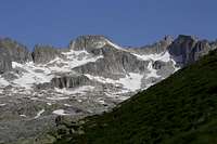
 | ridge of Monte Nero. This ridge, descending from the summit of Presanella is the longest of the group and hosts a lot of structures (summits, pinnacles, walls) made of the finest "tonalite" of the range but this side is not the best one, the amusement zone for rock climbers is the other side of the ridge, the one that borders the Val d'Amola. |
| Val d'Amola - very well known - a road allows to arrive by car up to more than 2000m (Vallina d'Amola) and, in about 1 hour walk, to arrive to the Rifugio Segantini - the starting point of the normal route to the main summit. |
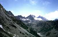
 | Its N border is a long ridge coming down from Cima dell Vedretta Nera till the famous and well frequented lakes of Cornisello On this ridge only three summits are worth to be mentioned : |
| North of this ridge the Val Cornisello with its lakes and wild "forgotten" summits on the |
for a photo | main ridge : from these summits many subridges go down in any direction bordering wild valleys seldom runned by hunters or "explorers" ... almost an "hic sunt leones" ... (as for my knowledge) |
Accesses - from North
From N side the Presanella group is really more simple, only 2 main valleys enter the group :| the Western one : Val Presena from the road of Passo del Tonale an untarred road allows to arrive up to ~2200m giving access to the whole western group summits : it's a long way ... that's why many summits are really very seldom climbed : the Busazza has more than 20 different routes from this side, but I could bet that some of them have never been climbed the second time. |
 | A big ridge, named Cresta di san Giacomo (St.James ridge) descending from Monte Cercen ends with the big important summit of Cima dei Pozzi (2890m) on whose walls I heard of many difficult rock routes. |
| East of this ridge the only well known valley of the group : the Val di Stavel - very fine, starting point is Vermiglio and gives access to the fine Rifugio Stavel Denza - starting point for the routes on the N wall of Presanella and Vermiglio and for the fantastic ski-mountaneering trip to Cima Presanella, passing through the Sella di Freshfield. |
 | the Val d Stavel, in its E side is bordered by an high ridge containing the last high mountains of the group : and the minor ones, but important "croz" of Scarpaco, Ricolonda and Monredont |
| East of this ridge the small Val di Ricolonda, looking fine for wild hiking adventures ... |