
-
 30153 Hits
-
 92.85% Score
-
 40 Votes
|
|
Area/Range |
|---|---|
|
|
46.67206°N / 11.36261°E |
|
|
Hiking, Mountaineering, Trad Climbing, Scrambling, Via Ferrata, Skiing |
|
|
Spring, Summer, Fall, Winter |
|
|
9124 ft / 2781 m |
|
|
1 - Overview
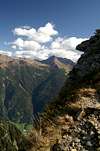
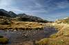
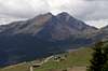
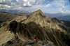
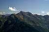
 Waltental Valley with Weißhorn at the back Waltental Valley with Weißhorn at the back |
The Sarntal Alps are the easternmost outpost of the Rhaetian Alps, a huge mountain group at the centre of the Alps which drew its name from the people who lived there 2000 years ago. The Rhaetians, who were conquered by the Romans in Emperor Augustus reign mingled with their conquerors, thus mingling the both languages into which what today is called Rhaeto-Romanian. After all the movements and conquests which took place in the last 2000 years only the remotest regions still prove that heritage.
The Sarntal Alps are not one of these regions since they are located so very close to the most important merchant routes of Europe, the Brenner Pass / Passo di Brennero. The area was one of the first which was conquered by the Romans and later got swamped by whoever was in charge of the pass. Moreover there are two very important additional passes in the group itself, Penser Joch / Passo di Pennes and Jaufenpass / Passo Giovo. Over time the two most important cities of the area developed in the shadow of the range, Bozen / Bolzano in the south and Meran / Merano in the west. Together with Sterzing / Vipiteno in the north and Brixen / Bressanone in the east these towns and cities ensured the importance of the area. Just remember that the Counts of Tyrol, who for some time goverend most parts of the eastern Alps originate in the village of Dorf Tirol / Tirolo high above Meran / Merano!
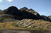
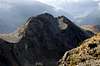
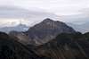
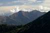
The mountain range itself, Sarntal Alps or Monti Sarentini, is seemingly of small importance when compared to its neighbours, the Ötztal Alps to the west, the Stubai Alps to the north, the Zillertal Alps to the north-east, the Geisler / Odle Group to the east and the Schlern Plateau to the south-east. True, the mountains of the group don't reach the impressive heights of its neighbours - there is (and never was) a single glacier in the group, much of it - the southern part - is smooth and seemingly dull - but wait until you see the northern summits of Hirzer, Hochwart, Weißhorn or Tagewaldhorn.
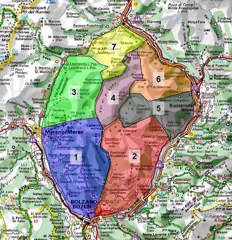
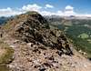
The Sarntal Alps Group is formed like a horseshoe, which is barely open to its south. The Sarntal Valley cuts deep into the group, but pens up as you reach the centre. The road from Bozen to Sarntheim with its uncountable narrow tunnels is one of the most impressive roads in the Alps. Rittner Horn / Corno di Renon, though only a rounded hilltop is one of the best lookout peaks you can find anywhere in the world. Located solitarily it offers perfect views in all directions, and as said above, the neighbours are worth looking at.
The mountains of the group are formed by various kinds of rock: limestone, gneiss, schist, quartz-phyllite. In the southern half of the group much of it is hidden beneath forests and meadows while in the north several impressive ranges can be found. Also, the most important and highest summits can be found here: Großer Ifinger, Hirzerspitze, Hochwart, Sarner Weißhorn and Tagwaldhorn. Apart from these mountains most other summits are not accessible by hiking trails.
The following geological information is taken from an addition wuedesau gave to me:
"Only a few but prominent peaks (such as Weißhorn) are made of limestone - marble. Almost all of the mountain group is composed of paleozoic crystalline rocks (gneisses, schists, quartz-phyllites) and volcanics (Bozen Quarzporphyr in the southern part of the mountain group). From the geological point of view the borders of the mountain group differ. Most prominent feature is the Periadriatic Line which marks the border between the East Alpine tectonic system (in the North) and the Southern Alps. This line runs through the upper Penser Valley over the ridge near Rotwandhütte to Meran. As a result the mountain ridge with Weißhorn, Hochwart and Hirzer belongs to the East Alpine Stubai-Ötztal Crystalline Complex while the rest belongs to the Southern Alps. Along the Periadriatic Line younger granites came up."
JaufenspitzeHochplattspitzeVerstadlspitzePlattenspitzeHochwartUnterbergSulzspitzeTagewaldhornHochalplspitzeHörtlahner SpitzeJakobspitzeSchafbergAlpler SpitzePfandlspitzeHirzerHönigspitzeVidegger PlattenspitzeKanzel PlattenspitzeVerdinser PlattenspitzeGroßer IfingerLauwandspitze 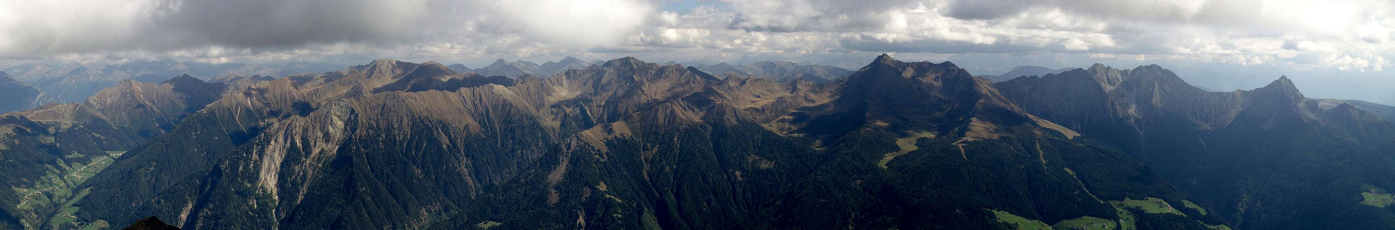  |
2 - The Sarntal Alps on SP
|
3 - Tschögglberg
Located between the Etsch / Adige Valley in the west and Sarntal Valley in the east this subgroup – while one of the largest of the Sarntal Alps – is one of the most insignificant. It is a single ridge which starts in the south at the provincial capital of Bozen / Bolzano and leads to the ski runs around Meraner Hütte east of Meran / Merano. The whole area – apart from the ski runs in the north and the highest summits along the main ridge– is covered in forests. Views are obscured by trees and by the higher Sarntal Alps ranges to the north and east. The highest summit of the group is Karkofel (2113m). Summits are listed south to north.- Schwarzeck / Dosso Nero (1525m)
- Dorfer Nock / Dosso (1840m)
- Möltner Joch / Malga di Meltina (1734m)
- Salbenberg / Monte Salve (1498m)
- Stoarnerne Mandln (Schöneck) (2003m)
![]()
- Vöraner Joch / Monte di Verano (1932m)
- Kreuzjoch / Giogo della Croce (2086m)
- Karkofel / Monte delle Vacche (2113m)
![]()
- Maiser Rast / Riposo di Maia (2026m)


4 - Ritten / Renon
Rittner HornSattelbergVillanderer BergJocherer BergRitzlarspitzeKassianspitzeGertrumspitzeLorenzspitzePlankenhornGaißhornGißplatteSchrotthornLeierspitzeLiffelspitzeJakobspitzeMuckleitenTagewaldhornMarchspitzeKasebachhörndlSchneelahnspitzeKarspitze 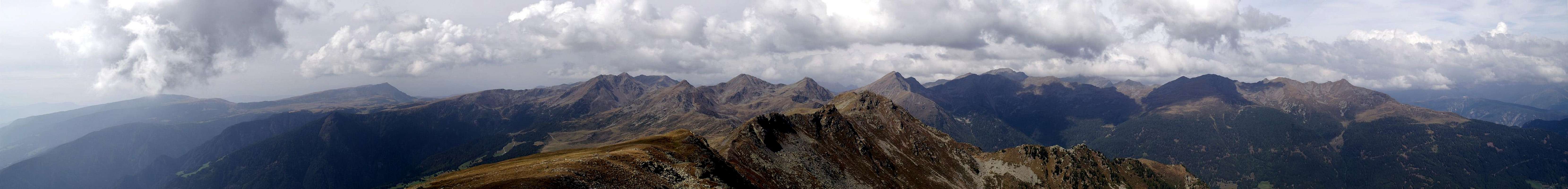 |
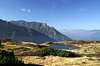
The south-eastern half of the Sarntal Alps Horseshoe is taken by the area called Ritten. The name was coined from the community of Ritten (Comune di Renon), an assortment of small mountain villages to the south and east of this subgroup. The best known mountain - while certainly unimpressive - is Rittner Horn / Corno di Renon, a solitary round-topped mountain, which is one of the best lookout summits all over the world. Just to the other side of the profound Eisack Valley / Val d'Isarco you can find the likes of Schlern / Sciliar, Langkofel / Saslonch and the Geisler / Odle Group. Most of the Ritten group resembles the hill-like south-western group on the opposite side of the Sarntal Valley but in the north-west some rough and impressive summits draw your attention.
The boundaries of the group are the Eisackvalley to the east and south, the Sarntal Valley to the west and the Gertrumtal and Latzfonser Tal Valleys to the north. The group consists of two ridges, a plump long one in the east and a rocky short one in the west. The highest summit of the group is Villanderberg, Monte Villandro (2509m) in the western ridge. In the east of the group you can find the famous Rittner Earth Pyramids (see section 10 below).
- Heidrichsberg / Monte Graveccio (1736m)
- Saubacher Kofl / Monte San Ingenuino (1771m)
- Schwarzseespitze / Punta Lago Nero (2069m)
- Rittner Horn / Corno di Renon (2260m)
![]()
- Bergrast / Monte del Riposo (2109m)
- Gißmann Nock / Colle di Madonnina (1924m)
- Florberg / Monte Vallario (1944m)
- Sattelberg / Monte Sella (2161m)
- Samberg / Monte Sommo (1833m)
- Hoadrichberg / Monte di Graveccio (1723m)
- Pfreiner Nock / Monte di Freina (1926m)
- Morgennock / Cima Mattina (1571m)
4.2. - Villanderer Ridge
- Kienberg / Mont' Abete (1417m)
- Gamser / Cima dei Camosci (2155m)
- Sarner Scharte / Monte Forcella Sarentina (2460m)
- Villandererberg / Monte Villandro (2509m)
![]()
- Nock-Seeberg / Monte del Lago (2145m)
- Wendelstein / Monte Macina (2109m)
- Gufelreit / Monte Covolo (2158m)
4.1 - Rittner Horn Ridge


5 - Hirzer Group
Rocky and Dolomite like the Hirzer Group is not only the highest but easily the most impressive subgroup of the Sarntal Alps. Lcated between Passeiertal Valley / Val Pasiria to the west and Penser Tal Valley / Val di Pennes to the east it is a single ridge with several short sideridges going off at odd angles. The southern boundary is at Schartboden near Meraner Hütte, the northern boundary is Wannsertal Valley with Wannser Joch. There are a whole lot of ski lifts which take you from Meran to the south of the subgroup, facilitating the ascent to the acessible summits a lot. Also, there is a cable-car from Saltaus / Saltusio to the western base of Hirzerspitze, with Hirzerhütte as one of the most important relay stations for any hike or climb in the group.Many of the summits of the Hirzer Group can only be reached by experienced climbers but the high trails and traverses make more than up to the lack of reasonable summits. Most popular are Großer Ifinger in the south of the group, Hirzerspitze in its centre and Hochwart to its north Hirzerspitze / Punta Cervina is the highest summit of the Sarntal Alps.
- Spieler / Grava (2078m)
- Schartboden (1964m)
- Öttenbacher Berg (2137m)
- Kleiner Mittager (2305m)
- Großer Mittager / Monte Catino (2422m)
- Essenberg / Montessa (2315m)
- Ebnenberg / Monte Piano (2123m)
- Kleiner Ifinger / Piccolo Ivigna (2552m)
![]()
- Großer Ifinger / Grande Ivigna (2581m)
![]()
- Lauwandspitze (2254m)
- Sinkefl / Giogo di Dosso (2052m)
- Graswand (2310m)
- Scheibenspitze / Cima del Bersaglio (2412m)
- Verdinser Plattenspitze / Laste di Verdins (2675m)
![]()
- Kanzel Plattinger Spitze / Pulpito (2673m)
- Videgger Plattenspitze / Punta di Lasta (2514m)
- Kratzberg / Monte San Pankrazio (2348m)
- Leiterspitze / Punta di Costa (2340m)
- Königspitze / Punta del Re (2700m)
- Hirzerspitze / Punta Cervina (2781m)
![]()
- Pfandlspitze / Cima di Pegno (2538m)
- Kreuzjoch / Monte Croce (2445m)
- Prantachkogel / Monte Prantago (2334m)
- Riffelspitze / Monte Sega (2060m)
- Grabenkopf / Monte delle Fosse (2620m)
- Schafberg / Monte delle Pecore (2347m)
- Säbelspitze / Punta Sciabola (2337m)
- Alpler Spitze / Punta dell’Alpetta (2748m)
![]()
- Hochalpl Spitze / Cima dell’Alpetta (2535m)
![]()
- Hühnerspiel / Cima Gallina (2451m)
- Harlingerjoch Spitze / Cima Arlengo (2413m)
- Plattenspitz / Punta di Lastè (2345m)
![]()
- Unterberg / Monte di Sotto (2669m)
![]()
- Hochwart / Guardia Alta (2746m)
![]()
- Verstadl / Monte di Pozza (2495m)
![]()
- Nörderspitze / Punta di Tramontana (2106m)
- Alpenspitze / Cima dell’Alpe (2477m)
- Seespitze / Cima del Lago (2430m)


6 - Gentersberg Ridge
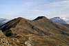
 Gentersbergkamm Ridge
The Sarntal Alps are formed like a horseshoe which is open to the south. However in its centre there is an additional ridge, reaching out south-westwards from the north-eastern base of the horseshoe. It is wedged between the Pensertal / Val di Pennes and Durnjolzer Tal / Valdurna Valleys, which split at St. Valentin / San Valentino north of Sarntheim / Sarentino and recombine at Traminscharte / Passo di Tramin. The subgroup is a single ridge towering above the two narrow valley. Its highest summit is Hortlaner Spitze / Punta Lavine near its north-eastern end.
- Auf der Katz (1795m)
- Leiterspitz / Cima Rodella Sud (2375m)
- Radelspitze / Cima Rodella (2422m)
- Kollmannspitze / Monte Colma (2388m)
- Hurlerspitze / Monte Corlo (2405m)
![]()
- Gentersbergspitze / Monte dei Masi (2411m)
![]()
- Hoferberg (2438m)
![]()
- Karnspitz / Cima di Quaire (2414m)
![]()
- Zirbeneck (2104m)
- Schönjöchlspitze / Cima di Giogobello (2308m)
- Poschbergspitze (2277m)
- Geißscheibenspitze / Cima della Capra (2337m)
- Hohe Scheiben (2563m)
![]()
- Paulswand / Croda di Paolo (2274m)
![]()
- Nebelseespitze / Cima Nebbia (2516m)
![]()
- Mutnelle / Mutanella (2657m)
- Hortlaner Spitze / Punta Lavine (2656m)


7 - Kassian Group
To the east of the Sarntal Alps there is a wedge of mountains which stretches from the city of Brixen / Bressanone towards the centre of the group. In the west of this wedge you find a three ridged circular group, almost resembling the big Sarntal Alps horseshoe but smaller and open in the west. There, above the village of Reinswald, you can find the Sarntal Ski runs, all running down the smooth slopes of the three ridges. In the centre of the subgroup you can find a couple of high summits, the highest of which is Kassianspitze / Cima San Cassiano. To the east, a long winding ridge leads down to Brixen and the Eisacktal Valley.- Pichlberg (2368m)
- Blankenhörnl (2383m)
- Morgenrast / Monte Mattina (2351m)
![]()
- Plattenjoch (2460m)
![]()
- Blankenhorn / Corno Bianco (2571m)
![]()
- Plattenspitze / Cima delle Lastè (2432m)
- Hirscheck / Punta del Cervo (2419m)
- Getrumspitze / Cima Gethruna (2569m)
![]()
- Samspitze (2552m)
![]()
- Kassianspitze / Cima San Cassiano (2581m)
![]()
- Ritzlarspitze (2474m)
![]()
- Gaißhorn / Cima della Capra (2514m)
![]()
- Plankenhorn / Corno Planca (2543m)
- Gißplatte / Monte Lasta (2323m)
- Lorenzispitze / Cima San Lorenzo (2481m)
- Eisköfele (2422m)
- Kühberg (2429m)
- Königsanger Spitze / Monte del Pascolo (2439m)
![]()
- Kuhberg (1997m)
- Radlseenock (2391m)
- Hundskopf / Monte Cane (2354m)
- Scheibenkofel (2252m)
- Rösselspitze / Monte Cavallino (2235m)


8 - Tramin Group
Like its eastern counterpart, the Hirzer Group, the Tramin Group is home to a number of high and wuite impressive Dolomite-like summits. Few of them can be explored by hiking trails but there is a high route traversing the main ridge of the group all the way from Penser Joch / Passo di Pennes in the north to Schalderer Scharte in the south. The group is quite complicated, the main ridge bending this way and that - sprouting numerous side ridges to the east and one (the Durnolz Ridge, see above) to the west. The north of the group can very easily be reached from the road pass at Penser Joch, making this part of the group popular and a little crowded. The highest summit is Jakobspitze / Cima di San Giacomo.- Schrotthorn / Corno del Ceppo (2590m)
![]()
- Leierspitze / Monte Lira (2541m)
- Liffelspitze / Monte Livolo (2592m)
- Pfannspitze / Croda Fana (2620m)
- Foltschenoispitze /Punta Valcenai (2662m)
- Tellerjochspitze / Montello (2563m)
![]()
- Jakobspitze / Cima di San Giacomo (2741m)
![]()
- Lorenzenspitze / Cima di San Lorenzo (2436m)
- Tagwaldhorn / Corno di Tramin (2708m)
![]()
- Sulzspitze / Cima di Sulz (2572m)
![]()
- Schönjoch / Giogo Bello (2333m)
- Tatschspitze / Montaccio di Pennes (2526m)
![]()
- Niedeck / Dosso Basso (2306m)
- Astenberg / Monte Lastè (2326m)
8.2 - South-Eastern Side Ridge
- Muckleiten / Costa delle Mosche (2561m)
- Kasebachhörndl (2573m)
- Schneelahnspitze / Cima delle Valanga (2539m)
- Karspitze / Punta Quaira (2517m)
- Sattelspitze / Monte Sella (2053m)
- Seekofl (1913m)
- Scheibenberg / Monte del Bersaglio (1925m)
- Waldkofel (1772m)
8.3 - North-Eastern Side Ridge
- Marchspitze / Cima Mercato (2542m)
- Kreutzjoch / Monte della Croce (2560m)
- Rotes Mandl (2414m)
- Scheibenspitze / Cima del Bersaglio (2378m)
- Schliefstalleck (1893m)
- Hochgschirr / Monte Casura (2450m)
- Sackermandl (2381m)
- Sandbühel (1806m)
8.1 – Main Ridge


9 - Weißhorn Group
The northernmost subgroup of the Sarntal Alps is located between the two road passes of Penser Joch / Passo di Pennes and Jaufenpass / Passo del Monte Giovo. It is easily the most accessible part of the mountain range as the passes are located at elevations of 2200m and 2100m respectively. There is a short east-west main ridge in the south and considerably longer north-south side ridges in the north. The highest summit of the group - and the most popular, quite naturally, is Sarner Weißhorn / Corno Bianco.- Rötenberg (2257m)
- Grubereck (2170m)
- Mudratsch / Mudraccio (2581m)
![]()
- Gröllerspitze (2590m)
- Sarner Weißhorn / Corno Bianco (2705m)
![]()
- Gartlspitze / Cima Corte (2582m)
- Röthenspitze / Punta Rossa (2441m)
- Gänsekragenspitze / Punta di Campo (2322m)
9.2 – Jaufen Ridge
- Ötschspitze / Cima di Accia (2590m)
- Gaschelbenspitze / Monte Casa (2455m)
![]()
- Hochplattspitze / Lasta Alta (2428m)
![]()
- Mittagspitze (2046m)
- Jaufenspitze / Punta di Monte Giovo (2481m)
![]()
9.3 – Weißhorn Ridge
- Hohe Ferschl / Monte Versilo (2365m)
- Hoferspitze / Monte Cavo (2378m)
- Rastl (2251m)
- Schönjoch (2012m)
9.4 – Etschen Ridge
- Etschenspitze / Monte Eccio (2430m)
![]()
- Salcher Spitze (2100m)
9.4 – Eastern Ridges
- Hühnerspiel (2306m)
![]()
- Hochrastl (2058m)
- Durraspitze (1966m)
- Zinseler / Cima di Stilves (2422m)
![]()
- Mandlseitejoch / Monte Mandola (2185m)
- Weiße Wand (2205m)
9.1 – Main Ridge


10 - Ritten Earth Pyramids / Piramidi di terra del Renon
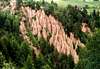
 Ritten earth pyramids
Far from being one of the major lookout locations for the western Dolomites, the area around Rittner Horn, the community of Ritten / Renon is famous for its “earth pyramids”. These pyramids are erosion forms in the eastern slopes of the Ritten Mountains, where much of the soil is easily washed away by rain. The earth pyramids of Ritten are made of glacial till. The grain size distribution of this sediment shows a very poorly graded chaotic sediment with a high amount of fines (silt) but also huge boulders. Rain washes away most of the till but beneath the embedded rocks and boulders it remains standing. Literally standing! The pyramids - which are but fleeting structures - reach a hight of some 10m / 30ft, always with a rock on top of their structures. Once the rock tumbles down the whole pyramid structure crumbles away in almost no time.
Again written with the help of wuedesau
|


11 - Getting There
The nearest international airports are Innsbruck in Austria and Verona in Italy. The following itineraries are given from these starting points. Luckily from both airports the route finding is quite easy- From Innsbruck
Simply take the Brenner Motorway A13(Austria) / A22 (Italy) south to Sterzing / Vipiteno. The town is located at the northern end of the Sarntal Alps. From there SS44 leads towards the north and west of the group via Jaufenpass / Passo di Giovo, while SS508 takes you across Penser Joch / Passo di Pennes into Sarntal Valley itself. Staying on the motorway takes you to Bozen / Bolzano in the south of the group.
- From Verona
Take Motorway A22 (Brenner Motorway) northward until you reach Bozen / Bolzano. Stay on the motorway for Sterzing / Vipiteno and the eastern part of the group or take SS38 north-west to Meran / Merano for the western part. In case you want to explore the wildly romantic Sarntal Valley itself, take SS508 north, which takes you through countless very narrow tunnels into the heart of the group.
12 - Red Tape
 Haflinger Horses. Hafling, which is famous for this breed lies west of the Sarntal Alps
There is no red tape to speak of. The area, especially the lower regions in the south and inside Sarntal Valley are used for extensive cattle grazing. Moreover many of the pastures are privately owned. While the regular hiking trails through private land can be used freely (you are actually encouraged to do so) be sure not to stray too far from them. Apart from this the usual rules apply - leave plants and animals, take your refuse, keep dogs on leash, close gates etc.
13 - Mountain Huts & Refuges
13.1 - Huts
There are some ten od huts in the group. Most, quite obviously, are located around the popular ski runs around Meran and around Rittner Horn. The following table gives an overview:
| Refuge / Hut | Height | Summer | Winter | Tel. | Thumbnails |
| Flaggerschartenhütte | 2481m | beg June - end Sept. | closed | + 39/0471/625251 |  |
| Hirzerhütte | 1938m | beg. July - end Oct. | closed | +39/0473/645600 | |
| Ifingerhütte | 1815m | beg May - end Sept. | closed | +39/336/451873 | |
| Klausener Hütte | 1923m | beg. June - end Oct. | closed | +39/0472/545194 | |
| Latzfonserkreuz Hütte | 2302m | beg. June - end Oct. | closed | +39/0472/545017 |  |
| Meraner Hütte | 1960m | beg. June - end Oct. | mid Dec. - beg. May | +39/0473/279405 | |
| Radlseehütte | 2257m | mid May - end Oct. | closed | +39/0472/855230 |  |
| Rittner Horn Haus | 2260m | beg. June - end Sept. | during ski season | +39/0471/356207 |  |
| Rotwandhütte | 1817m | all summer | all winter | +39/0473/279559 |
13.1 - Bivouacs
There is only one bivouac hut I know of:
| Bivouac | Height | Thumbnails |
| Sarner Schartenhütte | 2281m |
14 - Accommodation
14.1 - Eisacktal / Valle Isarco
14.2 - Passeiertal / Val Passiria
14.3 - Burggrafenamt
14.3 - Bozen / Bolzano
15 - Weather Conditions
In addition to the weather information on the sites you find under accommodation you can look up these sites:16 - Maps & Books
16.1 - Maps
- Digital Maps
- Regular Maps
- Sarntal/Val Sarentino
Kompass Map WK 056
1:35.000
ISBN: 3-85491-340-0
- Sterzing / Vipiteno
Kompass Map WK 44
1:50.000
ISBN: 3-85491-050-9
- Brixen / Bressanone
Kompass Map WK 56
1:50.000
ISBN: 3-85491-063-0
- Bozen / Bolzano
Kompass Map WK 54
1:50.000
ISBN: 3-85491-061-4
- WK 53 Meran und Umgebung / Merano e dintorni
Kompass Map WK 53
1:50.000
ISBN: 3-85491-059-2
- BOLZANO-RENON / BOZEN-RITTEN-TSCHÖGGLBERG
Tabacco Map 034
1:25.000
- MONTE SARENTINI / SARNTALER ALPEN
Tabacco Map 040
1:25.000
- Sarntal/Val Sarentino
16.2 - Books
- Bozen-Salten-Schlern
Kompass Guidebook WF953
Kompass Verlag
ISBN: 3-85491-406-7
- Meran-Burggrafenamt
Franziska Baumann
Kompass Guidebook WF951
Kompass Verlag
ISBN: 3-85491-386-9
- Rund um Bozen
Helmut Dumler
Rother Verlag
ISBN: 3-7633-4267-2
- Rund um Sterzing
Henriette Klier / Walter Klier
Rother Verlag
ISBN: 3-7633-4167-6
- Rund um Meran
Henriette Klier
Rother Verlag
ISBN: 3-7633-4290-7
wuedesau - Apr 6, 2006 7:25 am - Voted 10/10
some proposalsGood page but some confusion about directions: Jaufen Pass and Penser Joch are both N-S connections as Passeiertal and Sarntal are N-S valleys. Sterzing is in the North and Brixen in the West. Some additions to geology: Only a few but prominent peaks (such as Weißhorn) are made of limestone - marble. Almost all of the mountain group is composed of paleozoic crystalline rocks (gneisses, schists, quartz-phyllites) and volcanics (Bozener Quarzporphyr in the southern part of the mountain group). From the geological point of view the borders of the mountain group differ. Most prominent feature is the Periadriatic Line which marks the border between the East Alpine tectonic system (in the North) and the Southern Alps. This line runs through the upper Penser Valley over the ridge near Rotwandhütte to Meran. As a result the mountain ridge with Weißhorn, Hochwart and Hirzer belongs to the East Alpine Stubai-Ötztal Crystalline Complex while the rest belongs to the Southern Alps. Along the Periadriatic Line younger granites came up. The earth pyramids of Ritten are not composed of some "normal gravels with dirt" as you described but are made of glacial till. The grain size distribution of this sediment shows a very poorly graded chaotic sediment with a high amount of fines (silt) but also huge boulders.
Gangolf Haub - Apr 6, 2006 11:23 am - Hasn't voted
Re: some proposalsThanks a lot for the explanations. My sense of direction is a bit poor and I haven't really spent much time figuring out the geology. I'll quote you on the page.
franza mosco - Aug 16, 2006 4:47 pm - Voted 10/10
FlaggerschartenhütteAttention: this summer (2006) the Flaggerschartenhütte/rifugio Vallaga is CLOSED! :( I have been yesterday (08/15/2006)
franza mosco - Jul 15, 2007 8:23 am - Voted 10/10
FlaggerschartenhütteOnce again opened, since 1 July 2007
Gangolf Haub - Jul 16, 2007 7:36 am - Hasn't voted
Re: FlaggerschartenhütteThanks for the information!