|
|
Mountain/Rock |
|---|---|
|
|
48.58192°N / 113.66844°W |
|
|
Flathead |
|
|
Mountaineering |
|
|
Summer, Fall |
|
|
9597 ft / 2925 m |
|
|
Overview (Primary image photo by Distressbark)
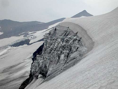
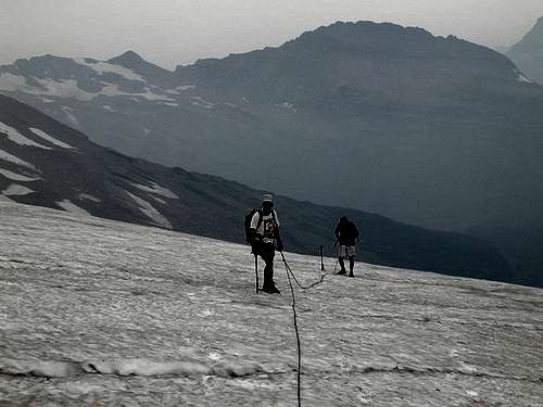
This is one of the gems of Glacier with the wild approach along the flanks of Mt Jackson beneath the Jackson glacier traversing across numerous glacial moraines and streams melting from the ice. The Blackfoot Glacier Route entails some 1 ½ miles across the glacier itself and the challenge of getting past the 60’ ice wallwhere the upper portion of the glacier is calving down to the lower portion. The views from the summit are even better than the scenery you are surrounded with en route. The Swan mountain range and Hungry Horse Reservoir are to the west. The Pumpelly Glacier clings the south side of Blackfoot Mountain. Across the deep Nyack valley looms Mt Stimson. To the north sits Mt Jackson and numerous peaks extending all the way to Canada. It is a mixed climb requiring ice ax and crampons as well as roped travel as a precaution for hidden crevasses. The crux is the great ice wall where a tremendous bergstrom forms making the crossing onto the cliffs beside the ice wall challenging. The summit is about 10 miles from the Jackson Glacier Overlook on the Going to the Sun Road and there is a human trail for almost 8 miles of this approach. The elevation gained on the standard approach is about 4,900’.
One approach to dealing with the long distances involved is to get a permit to camp at Gunsight Lake which is about six miles from the trailhead. This will make the summit day about 8 miles roundtrip if you spend another night at Gunsight Lake or 14 miles if you decided to head out to civilization. The rock climbing is not worse than Class 4 if correct routes are followed.
Getting There
Blackfoot Mountain is located in the Saint Mary valley area of the park which lies east of Logan Pass. You can access the Going to the Sun Road at the park entrances at West Glacier or at St Mary and from either location you head toward the opposite end of the road until reaching the Jackson Glacier Overlook which is about 5 miles east of Logan Pass on the south side of the road.Route Description
Blackfoot Glacier Route:Leave the Going to the Sun Road at the Jackson Glacier Overlook. From the parking area beside the road, you start downhill on the trail that leads to Gunsight Lake and continue to the lake about six miles. At the foot of the lake you will cross a footbridge and should be alert to a hikers path cutting off to the left around the northern end of Mt Jackson which you will have been enjoying taking pictures of as you approached the lake. The traverse across the Jackson Glacier basin soon transitions to cross country travel with few, if any, signs of use by humans. You will reach the great lateral moraine of the Jackson Glacier and it is best to work toward the lower end on your left to get past it. Here you will have to find a way across the waters melting off the Jackson Glacier and it may require heading upstream until a suitable location is found. Continue toward your goal gaining some 600’ to a waterfall draining the western lobe of the Blackfoot Glacier. Just north of the waterfall, the lower cliff can be climbed easily. You should now be by a large snowfield separated from the glacier by a low rocky ridge which you can walk up for ¼ mile to the glacier. At this point you should put on your crampons and rope up for a great glacier crossing that will take you almost to the summit.
Go toward the great ice cliff which is where you climb from the lower glacier you are on to the upper portion that is flowing down from the peak. A deep bergstrom develops on each side of the ice cliff and the safest route lies up the rocky wall west of the ice cliff. Belay the leader crossing over to the ledges beneath the wall. Once across the bergstrom, the wall can be climbed moving up the ledges to your right. Fairly high on the wall there is a good ledge angling to the right. Climb a bit higher and angle back to your left climbing to the top where you will be glad to get back on the steeply pitched glacier.Climb toward the ridgetop east of the summit and follow it west, bypassing on the north the two large crevasses that form a few hundred feet below the summit. From that point it is an easy walk up the talus slopes to the summit. Distance to the summit is about 10 miles
Mt Logan Ridge Route:
After taking the route toward Mt Logan, you can climb up to the connecting ridge west of Logan and follow it to Blackfoot. Ice axe and rope are needed to safely make it along this ridge top traverse. Distance to the summit is about 14 miles
The Southwest Cirque Route:
This approach is about 12 miles to the summit, but includes a ford of the Flathead River which can be deadly. Moreover there is technical climbing up the walls of the cirque with great exposure. There is a general description of this grueling climb in the following Climbers guide.
Guidebook: A Climber’s Guide to Glacier National Park
Camping
There are many camping sites available at Glacier Park; backcountry, as well as car camping. Due to the large number of grizzly and even larger number of black bears who inhabit the area, there are strict guidelines for storage of food. Most of the backcountry campgrounds have facilities for hanging your food from cables or bearproof poles, but you need adequate lines to hoist your packs, etc 15 or 20 feet off the ground. If you are seeking an “undesignated area” camping permit, the rangers may require you to use a bear barrel to protect your food. The GNP rangers require you to view an informational video annually before you can purchase your first backcountry permit.GNP Campground Status and Infor
Backcountry Camping Info
Backcountry Camping Sites
When to Climb
July, August, September and into October depending on the amount of snowExternal Links and Guidebooks
Glacier Mountaineers SocietyGuidebook: A Climber’s Guide to Glacier National Park
Trail guide: Hiking Glacier and Waterton Lakes National Parks


